
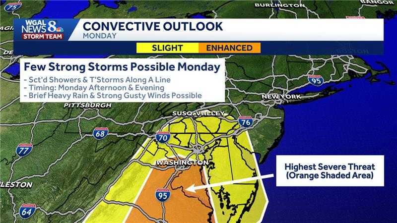
BE IN THE UPPER 40S AND LOW 50S ACROSS THE SUSQUEHANNA VALLEY THE NEXT THREE DAYS THOUGH. THE WEEKEND LOOKS GOOD. SATURDAY ESPECIALLY SEASONABLE, WILL BE WILL BE BREEZY AT TIMES AND THEN 54 ON SUNDAY WITH SHOWERS LATE AFTER SUNSET. EXPECTED. MONDAY. SOME SCATTERED SHOWERS AND THUNDERSTORMS, WITH A HIGH AROUND 64 DEGREES. UNFORTUNATELY, SOME OF THOSE STORMS COULD BE ON THE STRONG SIDE. THE STORM PREDICTION CENTER ALREADY HIGHLIGHTING OUR AREAS ALONG AND SOUTH OF THE PENNSYLVANIA TURNPIKE FOR A FEW STRONG STORMS DURING THE AFTERNOON AND EVENING, AND WE ARE WATCHING FOR BRIEF HEAVY RAIN. STRONG WIND GUSTS POSSIBLE AS THOSE STORMS FORM. THE RISK IS ACTUALLY GREATER, THOUGH. IN PARTS OF VIRGINIA WHERE YOU SEE THAT YELLOW ORANGE HIGHLIGHTED AREA. SO THIS WILL BE SOMETHING THAT WE CONTINUE TO WATCH THROUGHOUT THE WEEKEND AS THE TIMING OF THAT COLD FRONT, SUSAN
LOOKING AHEAD: Strong thunderstorms possible Monday in south-central Pennsylvania

Updated: 12:49 PM EDT Mar 13, 2026
The WGAL News 8 Storm Team is closely monitoring the potential for strong thunderstorms in south-central Pennsylvania on Monday.Scattered showers and storms are expected to develop ahead of a cold front. If storms strengthen, they could produce heavy downpours, frequent lightning and damaging wind gusts.What’s driving the threat A storm system will move from the Mississippi Valley into the Mid-Atlantic and Northeast.Southerly winds will pull in warmer, more humid air, with dew points near 60 degrees, possibly reaching southeastern Pennsylvania by Monday evening.The progression of the cold front will determine how widespread the severe risk becomes. Main impacts Damaging wind gustsFrequent lightningPeriods of heavy downpoursWhat to do Stay updated with the latest weather forecast. The Storm Team will provide updates as new data becomes available. Be prepared for downed tree limbs, isolated power outages and hazardous travel if storms intensify. SOUTH-CENTRAL PA WEATHER RESOURCES: INTERACTIVE RADAR | ACTIVE WEATHER ALERTS | CURRENT CONDITIONS | HOURLY FORECAST | 10-DAY FORECAST | WEEKEND FORECAST | MAP ROOM | DOWNLOAD THE APP | WEATHER EMAILS
The WGAL News 8 Storm Team is closely monitoring the potential for strong thunderstorms in south-central Pennsylvania on Monday.
Scattered showers and storms are expected to develop ahead of a cold front. If storms strengthen, they could produce heavy downpours, frequent lightning and damaging wind gusts.
What’s driving the threat A storm system will move from the Mississippi Valley into the Mid-Atlantic and Northeast.Southerly winds will pull in warmer, more humid air, with dew points near 60 degrees, possibly reaching southeastern Pennsylvania by Monday evening.The progression of the cold front will determine how widespread the severe risk becomes.

Main impacts
Damaging wind gustsFrequent lightningPeriods of heavy downpours

What to do Stay updated with the latest weather forecast. The Storm Team will provide updates as new data becomes available. Be prepared for downed tree limbs, isolated power outages and hazardous travel if storms intensify.
SOUTH-CENTRAL PA WEATHER RESOURCES: INTERACTIVE RADAR | ACTIVE WEATHER ALERTS | CURRENT CONDITIONS | HOURLY FORECAST | 10-DAY FORECAST | WEEKEND FORECAST | MAP ROOM | DOWNLOAD THE APP | WEATHER EMAILS