
Western PA: Rain ends Wednesday night, colder Thursday
The severe threat from storms is over.
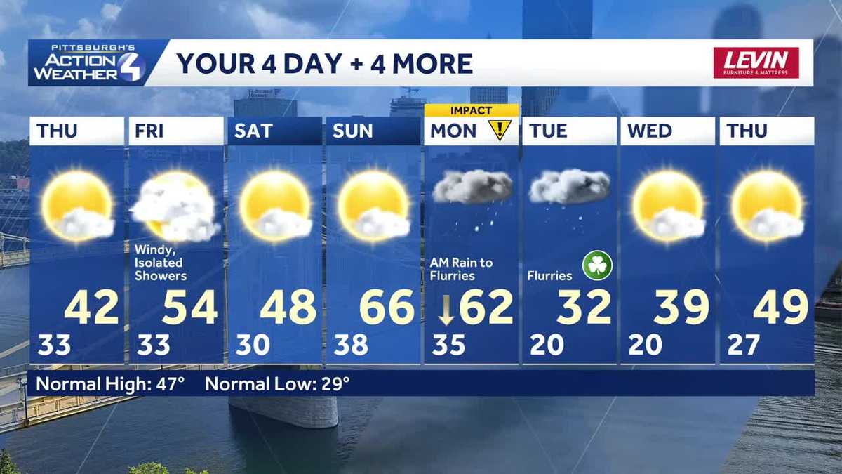
THREAT IS OVER. STILL SOME RAIN FALLING, SOME MODERATE RAIN AS WELL. SEVERE WEATHER THOUGH IS DONE AND THESE RAIN SHOWERS WILL EXIT HERE OVER THE NEXT FEW HOURS TONIGHT. SO YOU’LL HEAR THE RAINDROPS ON YOUR ROOF A LITTLE WHILE LONGER, BUT THEY WILL TAPER OFF WELL BEFORE WE GET TO SUNRISE TOMORROW MORNING. REALLY, NO THUNDER LEFT FOR THIS. YOU MAY STILL HEAR A RUMBLE, BUT THAT’S REALLY THE WORST. WE’LL INDOOR TONIGHT AS THE RAIN IS CONTINUING TO TAPER OFF AND AS OUR COLD FRONT SWINGS THROUGH WILL USHER IN COLDER AIR. THAT IS WITH US AS WE HEAD INTO THE END OF THE WEEK. SO THOSE RAIN SHOWERS ARE FALLING NOW. THESE WILL CONTINUE DRIFTING SOUTH AND EASTWARD NORTH OF THE CITY AND NORTHWEST OF THE CITY. WE SHOULD BE CLEAR BY ABOUT 2:00 IN THE MORNING. EVERYBODY ELSE WILL BE CLEAR BY THE TIME WE GET TO SUNRISE. THERE MAY BE A FEW FLAKES IN THE LAUREL HIGHLANDS TOMORROW MORNING, AND THEN SUNSHINE WILL START POKING THROUGH AS WE HEAD INTO THE AFTERNOON AND EVENING HOURS. NOT A BAD DAY, BUT IT IS GOING TO BE COLDER. IT’S SEASONABLY COOL, BUT CONSIDERING WE CLIMB INTO THE 70S TODAY, FOR MANY OF US, IT’S GOING TO FEEL MUCH COLDER THAN THAT. A LOT OF US HAVE SEEN OVER AN INCH OF RAIN SO FAR TODAY. AS WE EXPECTED. IN FACT, OFFICIALLY AT THE AIRPORT, WE HAVE SET THE RECORD FOR THE DATE WITH RAINFALL AND IT’S STILL RAINING ACROSS WESTERN PENNSYLVANIA. AND BECAUSE ALL THAT RAIN HAS TO DRAIN INTO OUR RIVERS, WE NOW WATCH THEM INTO THE WEEKEND. THE OHIO RIVER AT PITTSBURGH IS EXPECTED TO CREST LATE TOMORROW AT 18.5FT. THE MON WHARF FLOODS AT 18FT, AND SO THERE IS A FLOOD ADVISORY OUT FOR THE CITY OF PITTSBURGH. WE’LL WATCH ALL OF OUR RIVERS, BUT THIS IS THE ONLY ONE CURRENTLY EXPECTED TO REACH FLOOD. STAGE 42 IS YOUR HIGH TEMPERATURE TOMORROW. AGAIN, WE WERE NEAR 70 FOR MOST OF US TODAY, 54 DEGREES. ON FRIDAY. THE WIND PICKS UP. WINDS WILL GUST POTENTIALLY IN EXCESS OF 40MPH. WE HAVE TO WATCH FOR A COUPLE OF SNOWFLAKES NORTH. OTHERWISE IT’S REALLY JUST A COUPLE OF ISOLATED SHOWERS AS WE HEAD THROUGH THE DAY. NOT A WASHOUT, BUT SOME RAINDROPS WILL BE AROUND 48 AS WE HEAD INTO YOUR SATURDAY. A COLD DAY WILL START AT 30. SO IF YOU’RE MAKING PLANS FOR THE SAINT PATRICK’S DAY PARADE WILL BE ABOUT 37. WHEN THE PARADE STEPS OFF AT 10:00, BUT WE WILL SEE LOTS OF SUNSHINE AND MOST IMPORTANTLY, WE’RE DRY 66 FOR US ON SUNDAY. THAT’S THE PICK OF THE WEEKEND. IT IMPACT DAY. MONDAY A SYSTEM ARRIVES. IT BRINGS RAIN SHOWERS WILL TRANSITION TO FLURRIES AS OUR TEMPERATURES DROP. SOME LEFTOVER FLURRIES ON TUESDAY AT 32. THEN IT’S BACK TO 39
Western PA: Rain ends Wednesday night, colder Thursday
The severe threat from storms is over.

Updated: 11:25 PM EDT Mar 11, 2026
The final batch of rain is tied to the cold front and will move through early in the night. Rain will exit after midnight with temperatures dropping into Thursday.Feeling more like mid-MarchThis front will dramatically drop temperatures for the second half of the week. Instead of the 60s and 70s, we will only manage the 40s Thursday. A few early morning wet flakes could fly in the Laurel Highlands. Temperatures trend more seasonal late next week with highs in the 40s and 50s. Isolated rain showers are possible again on Friday.St. Patrick’s Day outlookThe outlook is dry but brisk for the Pittsburgh St. Patrick’s Day parade on Saturday. The chillier pattern will extend into the start of next week. Another cold front will arrive Monday morning. Monday is an Impact Day as rain arrives during the morning commute. The system will bring rain, falling temperatures, and a transition to some snowflakes. As of now, little to no accumulation is expected.TONIGHT: Rain exits with flurries east of Pittsburgh. Low: 33°.THURSDAY: Colder with lingering early morning rain showers. High: 42°, low: 33°.FRIDAY: Cloudy with isolated showers and flurries. Wind gusts to 40 mph. High: 54°, low: 30°.SATURDAY: Partly to mostly cloudy. High: 48°.
PITTSBURGH —
The final batch of rain is tied to the cold front and will move through early in the night. Rain will exit after midnight with temperatures dropping into Thursday.
Feeling more like mid-March
This front will dramatically drop temperatures for the second half of the week. Instead of the 60s and 70s, we will only manage the 40s Thursday. A few early morning wet flakes could fly in the Laurel Highlands. Temperatures trend more seasonal late next week with highs in the 40s and 50s. Isolated rain showers are possible again on Friday.
St. Patrick’s Day outlook
The outlook is dry but brisk for the Pittsburgh St. Patrick’s Day parade on Saturday.

Hearst Owned
Chilly but dry for the St. Patrick’s Day parade in Pittsburgh.
The chillier pattern will extend into the start of next week. Another cold front will arrive Monday morning. Monday is an Impact Day as rain arrives during the morning commute. The system will bring rain, falling temperatures, and a transition to some snowflakes. As of now, little to no accumulation is expected.

Hearst Owned
More seasonal heading into the weekend before another system brings rain and snowflakes on Monday.
TONIGHT: Rain exits with flurries east of Pittsburgh. Low: 33°.
THURSDAY: Colder with lingering early morning rain showers. High: 42°, low: 33°.
FRIDAY: Cloudy with isolated showers and flurries. Wind gusts to 40 mph. High: 54°, low: 30°.
SATURDAY: Partly to mostly cloudy. High: 48°.