
The highs winds finally subside. This weekend will be dry from start to finish. It’s a cool start ahead of May-like feeling again on Sunday. Monday is an Impact Day with rain changing to flurries. Dry for St. Patrick’s Day weekend celebrationsShaking off the chill under partly to mostly sunny skies today. The wind will continue to relax through the afternoon. Highs will manage the upper 40s; seasonal for mid-March. Sunday is the pick of the weekend as highs warm to near 70 degrees with increasing clouds late in the day. It will turn breezy too with afternoon gusts of 30 to 40 mph.Impact Day Monday for rain changing to flurriesAnother cold front will arrive Monday late morning. Monday is an Impact Day as rain arrives during the morning commute. Isolated strong to severe thunderstorms are possible through the first half of the day. Damaging winds are the primary threat.Strong winds of 35 to 40 mph are expected as the cold front clears the area early in the afternoon. Temperatures fall from the 60s in the morning to the 40s by late afternoon. Any leftover moisture Monday afternoon and evening could be squeezed out as a few flurries. Little to no accumulation is expected from any flurries.Chilly through mid-weekWe keep some flurries for Tuesday and stay chilly for the middle of next week. Tuesday’s wind chills will be in the teens. Temperatures will gradually improve by next weekend. Spring officially begins at 10:46 a.m. Friday.TODAY: Winds subside. Seasonal with sun and clouds. High: 48°.TONIGHT: Mainly clear and chilly. Low: 38°.SUNDAY: Warmer and turning breezy with increasing clouds. High: 68°.MONDAY – Impact Day: Rain changes to flurries late. Windy with falling temperatures. Mid-day high of 64°, low: 20°.TUESDAY: Colder and still breezy with flurries. High: 28°, low: 20°.
PITTSBURGH —
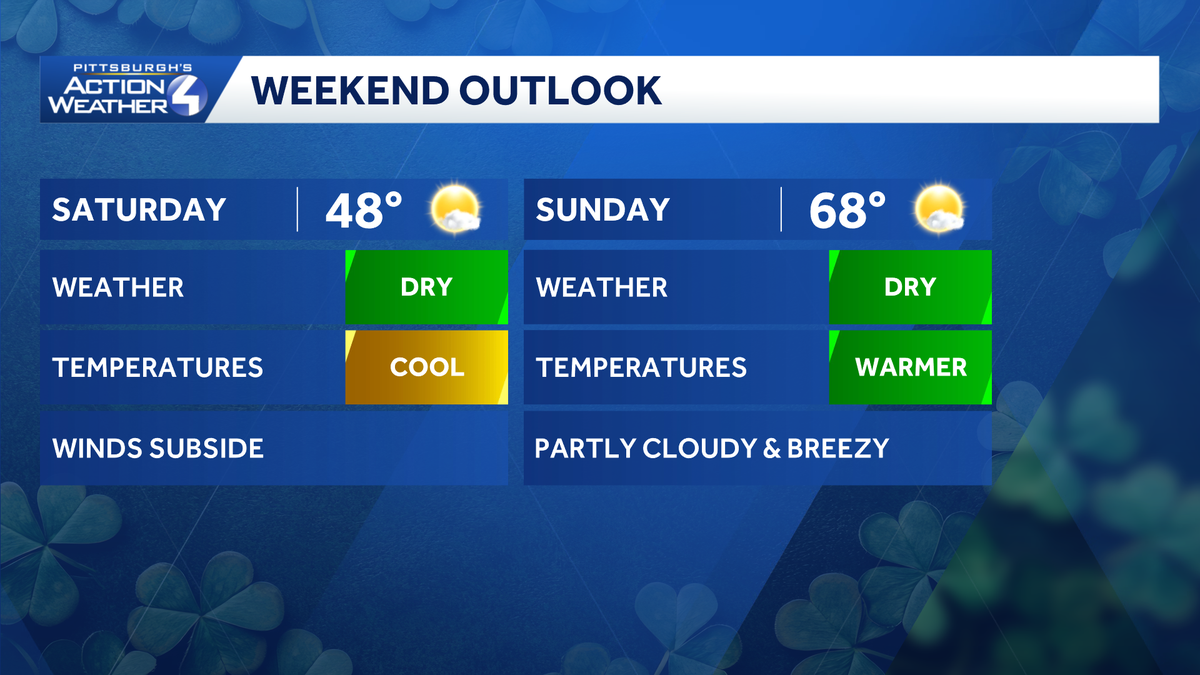
The highs winds finally subside. This weekend will be dry from start to finish. It’s a cool start ahead of May-like feeling again on Sunday. Monday is an Impact Day with rain changing to flurries.
Dry for St. Patrick’s Day weekend celebrations
Shaking off the chill under partly to mostly sunny skies today. The wind will continue to relax through the afternoon. Highs will manage the upper 40s; seasonal for mid-March.

Hearst OwnedHearst
Temperatures vary but this weekend is dry from start to finish for the Pittsburgh area.
Sunday is the pick of the weekend as highs warm to near 70 degrees with increasing clouds late in the day. It will turn breezy too with afternoon gusts of 30 to 40 mph.
Impact Day Monday for rain changing to flurries
Another cold front will arrive Monday late morning. Monday is an Impact Day as rain arrives during the morning commute. Isolated strong to severe thunderstorms are possible through the first half of the day. Damaging winds are the primary threat.

Hearst OwnedHearst
Monday is an Impact Day with rain and isolated strong storms early. Temperatures crash with late-day flakes possible.
Strong winds of 35 to 40 mph are expected as the cold front clears the area early in the afternoon. Temperatures fall from the 60s in the morning to the 40s by late afternoon. Any leftover moisture Monday afternoon and evening could be squeezed out as a few flurries. Little to no accumulation is expected from any flurries.
Chilly through mid-week
We keep some flurries for Tuesday and stay chilly for the middle of next week. Tuesday’s wind chills will be in the teens. Temperatures will gradually improve by next weekend. Spring officially begins at 10:46 a.m. Friday.

Hearst OwnedHearst
Temperatures remain chilly through mid-week. An upward trend begins in time to welcome spring.
TODAY: Winds subside. Seasonal with sun and clouds. High: 48°.
TONIGHT: Mainly clear and chilly. Low: 38°.
SUNDAY: Warmer and turning breezy with increasing clouds. High: 68°.
MONDAY – Impact Day: Rain changes to flurries late. Windy with falling temperatures. Mid-day high of 64°, low: 20°.
TUESDAY: Colder and still breezy with flurries. High: 28°, low: 20°.