
Breezy conditions will persist, then eventually relax late this evening. Cloud cover will decrease from the west as the wind continues to calm. Lows drop close to seasonal averages in the low to mid 30s.More clouds are on tap ahead of the next approaching weather system. It is dry with highs in the lower 50s. The winds pick up during the day, becoming breezy by afternoon. Spotty showers may develop late, especially overnight. IMPACT DAY MONDAY: STRONG & SEVERE THUNDERSTORMS POSSIBLEScattered showers are possible early morning. As of now, with the approach of a strong cold front, a line of strong to severe storms are expected ahead of and along the front. The timing of strong to severe storms is during the afternoon and early evening. The main threats are damaging wind gusts, locally heavy rainfall, and there is a low tornado threat.Most of the Susquehanna Valley is under an Enhanced Risk. This means scattered to numerous severe storms are possible. This type of outlook only happens 5 to 6 times a year on average. Please take this threat seriously. Unlike the last storm system, instability will not be a limiting factor.Expect windy conditions to return. Highs will range from the low to upper 60s. During the evening, with much colder air ushering in behind the cold front, precipitation may turn to a mix, especially in higher elevations.Behind the front, temperatures plummet to the low to mid 30s on St. Patrick’s Day. Gusty winds out of the west and northwest will lead to wind chill values in the 20s.The rest of the week is dry with more seasonable temperatures returning for the first day of Spring on Friday.
Breezy conditions will persist, then eventually relax late this evening. Cloud cover will decrease from the west as the wind continues to calm. Lows drop close to seasonal averages in the low to mid 30s.
More clouds are on tap ahead of the next approaching weather system. It is dry with highs in the lower 50s. The winds pick up during the day, becoming breezy by afternoon. Spotty showers may develop late, especially overnight.
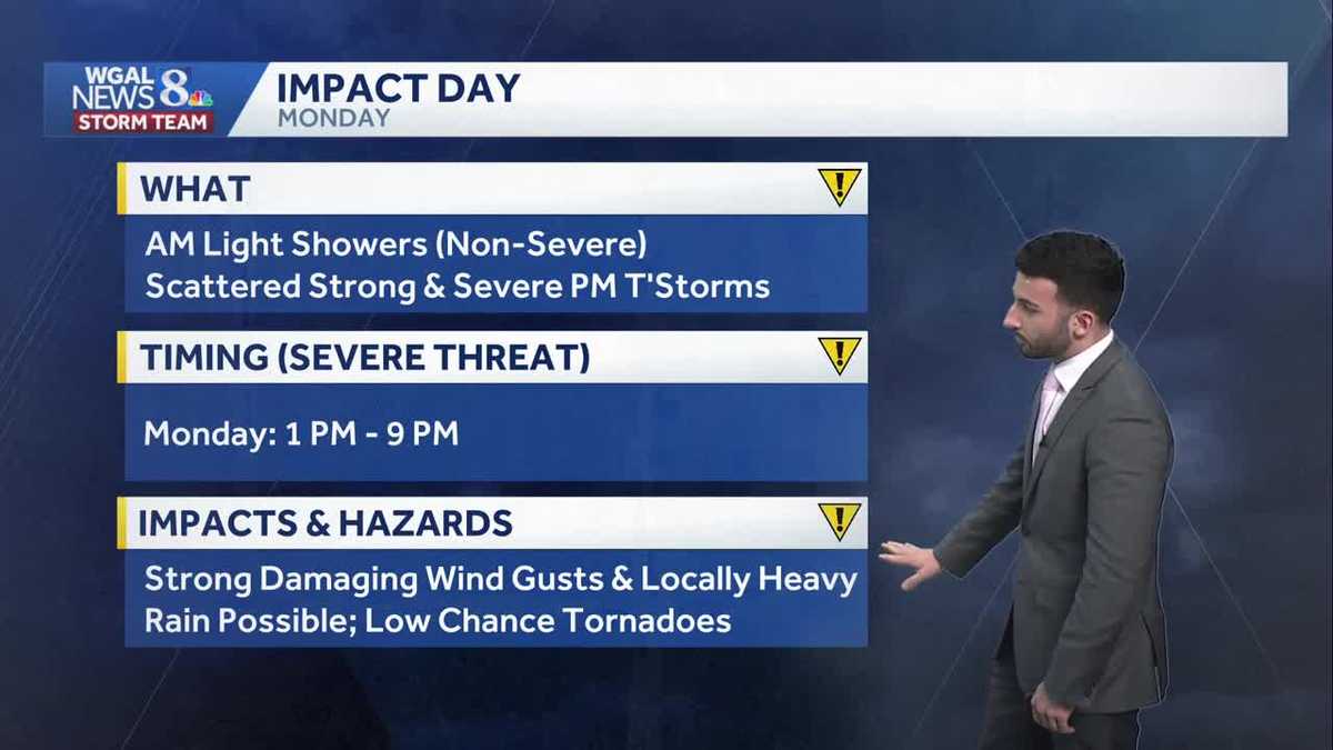
IMPACT DAY MONDAY: STRONG & SEVERE THUNDERSTORMS POSSIBLE
Scattered showers are possible early morning. As of now, with the approach of a strong cold front, a line of strong to severe storms are expected ahead of and along the front. The timing of strong to severe storms is during the afternoon and early evening. The main threats are damaging wind gusts, locally heavy rainfall, and there is a low tornado threat.
Most of the Susquehanna Valley is under an Enhanced Risk. This means scattered to numerous severe storms are possible. This type of outlook only happens 5 to 6 times a year on average. Please take this threat seriously. Unlike the last storm system, instability will not be a limiting factor.
Expect windy conditions to return. Highs will range from the low to upper 60s. During the evening, with much colder air ushering in behind the cold front, precipitation may turn to a mix, especially in higher elevations.
Behind the front, temperatures plummet to the low to mid 30s on St. Patrick’s Day. Gusty winds out of the west and northwest will lead to wind chill values in the 20s.
The rest of the week is dry with more seasonable temperatures returning for the first day of Spring on Friday.