
Dry & breezy for Sunday; stray shower chance late; severe storms Monday across south-central Pennsylvania
Cloud cover will increase overnight & stick around for the majority of Sunday. Expect a stray shower chance Sunday night. Strong to severe storms are on tap for Monday afternoon.
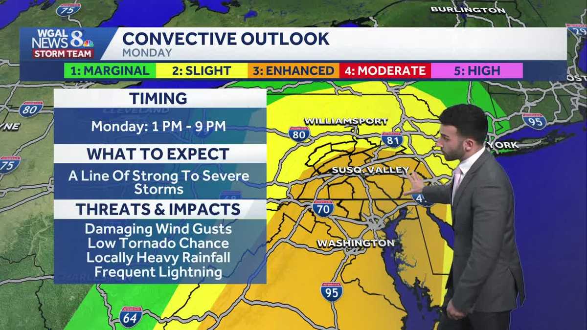
GABRIELLE AND MIKE SUSKO ALL RODE ALONG THE PARADE ROUTE AND RYAN ENDED UP BEING A PRETTY BEAUTIFUL DAY FOR THESE EVENTS. A LITTLE COLD, A LITTLE CHILLY, BUT SO SUNNY. SO GORGEOUS. YES, ABSOLUTELY. AND THERE’S SOME WINDS OUT THERE. THE WINDS WERE CRANKING EARLIER TODAY, BUT THEY HAVE SINCE RELAXED. SO THAT’S, THAT’S THAT IS SOME GOOD NEWS FOR THOSE WHO ARE HOPING FOR THE WINDS TO REALLY DIE DOWN. YOU CAN SEE THERE ARE SOME CLOUDS THAT ARE MOVING IN ON OUR LEBANON SKY CAM. WE’RE GOING TO CONTINUE TO SEE INCREASING CLOUDS THROUGH THE OVERNIGHT PERIOD, 44 DEGREES. IF YOU’RE TUNING IN FROM LEBANON CITY, NORTH NORTH WESTERLY WIND AROUND FIVE MILES PER HOUR, I WOULD SAY FOR THE CITY, BUT GRAY SKIES AS WE GET INTO THE SECOND HALF OF THE WEEKEND REMAINS MAINLY DRY UNTIL WE GET LATER INTO THE DAY. THEN ALL EYES ARE ON MONDAY. WE’VE MADE MONDAY AN IMPACT DAY FOR THE THREAT OF SEVERE WEATHER. WE’RE TRACKING A LINE OF SHOWERS AND STORMS WITH THE MAIN THREAT BEING DAMAGING. WIND GUSTS CAN’T RULE OUT A BRIEF SPIN UP TORNADO EITHER. SOME HEAVY RAINFALL, WHICH WE’LL TALK ABOUT THE DETAILS FOR MONDAY HERE IN A SECOND, BUT IT WILL BE COLDER AND BLUSTERY AS WE HEAD INTO THE MIDDLE OF THE WORKWEEK. IN THE WAKE OF THE COLD FRONT THAT’S GOING TO PUSH THROUGH ON MONDAY, ALMANAC FOR THE DAY TODAY HIT A HIGH OF 53 DEGREES. USUALLY HIT USUALLY EXPECT 50 DEGREES FOR THIS TIME OF THE YEAR, SO WE’RE SEASONABLE FOR FROM EARLIER THIS AFTERNOON. SO WE’LL BE MOSTLY CLOUDY OVERNIGHT TONIGHT WITH LIGHT TO CALM WINDS. WE’LL HAVE THAT SEASONAL CHILL IN THE AIR WILL BE DOWN INTO THE MID 30S. THEN FOR TOMORROW MORNING 38 TO 42 DEGREES. INCREASING WINDS OUT OF THE NORTH. AND THEN THEY’LL BEGIN TO SHIFT TO THE SOUTHEAST. ONCE WE GET INTO THE AFTERNOON IT’LL BE MOSTLY CLOUDY AND COOLER. BUT YOU CAN SEE THOSE WINDS OUT OF THE SOUTHEAST BETWEEN 10 AND 20MPH. SO ANOTHER BIT OF A BREEZY DAY STILL REMAINS DRY. SO IF YOU HAVE PLANS FOR THE AFTERNOON, YOU SHOULD BE FINE. YOU’LL BE GOOD TO GO. IT WON’T BE UNTIL WE GET LATER INTO THE EVENING FOR YOUR SUNDAY. THAT’S WHEN WE’LL START TO SEE THAT SHOWER CHANCE BEGIN TO MOVE THROUGH. WE’LL BE RIGHT INTO THE LOWER 50S FOR TOMORROW AFTERNOON’S HIGHS. NOW MONDAY, LOOKING AHEAD, WE’RE LOOKING AT MORNING SHOWERS TO START. THEN WE’LL SEE THOSE AFTERNOON AND EVENING THUNDERSTORMS BEGIN TO MOVE THROUGH. AND THOSE COULD BE STRONG TO SEVERE WEATHER. WE ARE IN A LEVEL THREE OUT OF FIVE SEVERE RISK. I’LL SHOW YOU THAT IN A GRAPHIC IN A COUPLE OF MINUTES. BUT THIS IS ALSO WHAT WE’RE TRACKING FOR OUR MONDAY AFTERNOON TEMPERATURES. GETTING INTO THE LOWER TO MID 60S. SO DEFINITELY GOING TO BE ANOTHER MILD DAY AND ANOTHER WINDY DAY. LOOK AT THIS WINDS UP TO ABOUT 15 TO 25MPH WITH GUSTS UP TO 40MPH FOR OUR MONDAY. SO YOU CAN SEE TEMPERATURES INTO THE 30S FOR LANCASTER AND YORK AT THIS TIME, 40S FOR LEBANON. HARRISBURG-CARLISLE, UPPER 40S FOR GETTYSBURG AND CHAMBERSBURG AND LEWISTOWN, RIGHT AROUND 43 DEGREES. BUT WINDS THEY’VE THEY’VE RELAXED OUT OF THE NORTH. SO I’D SAY LIGHT AND VARIABLE RIGHT NOW, BUT THAT WILL BE A DIFFERENT STORY ONCE WE GET INTO THE AFTERNOON. YOU SEE WINDS COMING IN FROM THE SOUTHEAST BETWEEN. GENERALLY YOU CAN SEE 15 TO 20MPH FOR THE AFTERNOON. NOW I SEE THAT YOU’RE WE’RE SEEING SOME SHOWERS, BUT IT LOOKS LIKE THERE’S SOME SHOWERS ON STORM TEAM LABORATORY NETWORK. WHEN I TURN ON LIVE LOCAL LATE RADAR. LOOK AT THIS. THERE’S NO THERE’S NO PRECIPITATION ACTUALLY MAKING IT TO THE GROUND. WHAT’S HAPPENING IS THAT THIS IS VIRGA PRECIPITATION THAT FALLS AND THEN DRIES ON THE WAY, ON THE WAY DOWN, OR JUST EVAPORATES ON THE WAY DOWN FROM THE CLOUDS. SO THAT’S REALLY WHAT WE’RE SEEING WITH STORM TEAM LIVE RADAR NETWORK. NOW, IN TERMS OF OUR FORECAST FOR TOMORROW, STILL HAVE A LITTLE BIT OF HIGH PRESSURE THAT’S NEARBY, BUT IT’S MOVING OUT TO THE NORTHEAST. SO I’M REALLY LOOKING AT MOSTLY CLOUDY CONDITIONS DEVELOPING AND ALSO THAT’S ALL THANKS TO THIS NEXT SYSTEM THAT’S GOING TO START TO PUSH THROUGH ONCE WE GET INTO OUR MONDAY. SO LOOKING AT JUST A LATE SHOWER CHANCE, YOU CAN SEE THE TIME STAMP. 630 I’D SAY MAYBE 7:00, 8:00, I’D SAY I’M NOT GOING TO RULE OUT SOME OF THESE STRAY SHOWERS COMING IN FROM THE SOUTH MAKING THEIR WAY NORTH. BUT THEN HERE COMES OUR MONDAY, MONDAY MORNING. GOT A WARM FRONT THAT’S GOING TO PUSH THROUGH. THAT’S GOING TO TRIGGER SOME MORNING SHOWERS. HERE COMES THE AFTERNOON. THESE THUNDERSTORMS. OH MAN. THIS IS GOING TO BE SOMETHING WE’RE GOING TO BE WATCHING AS WE GET INTO THE AFTERNOON. YOU CAN SEE ALL THOSE DEEPER REDS THE DARKER REDS HERE. YOU CAN SEE STARTING TO COME THROUGH THE SUSQUEHANNA VALLEY. AND IN THE WAKE OF THIS COLD FRONT WE MAY SEE A CHANCE OF SOME SNOW AS WE GET INTO AS WE GET INTO LATE MONDAY. BUT LET’S CHAT ABOUT THE SEVERE WEATHER THOUGH FOR THE AFTERNOON. AS YOU CAN SEE, MAJORITY OF THE SUSQUEHANNA VALLEY HIGHLIGHTED IN THAT LEVEL THREE. THIS ENHANCED RISK FOR SEVERE WEATHER DURING THIS TIME FRAME 1 P.M. TO 9 P.M. IT’S A LINE OF STRONG TO SEVERE STORMS. THE THREATS HERE DAMAGING WINDS, LOCALLY HEAVY RAIN, FREQUENT LIGHTNING AND WE COULD SEE A LOW TORNADO CHANCE BY THE WAY FOR THE AFTERNOON. SO THAT’S WHAT WE’RE GOING TO BE WATCHING. JUST SOME EXTRA DETAILS. AS YOU CAN SEE HERE FOR THE FOR THE AFTERNOON. THAT’S WHY WE MADE IT AN IMPACT ALREADY FOR THE BEGINNING OF THE WORKWEEK. BLUSTERY AND COLD. IN THE WAKE OF THE COLD FRONT THAT PUSHES THROUGH TUESDAY
Dry & breezy for Sunday; stray shower chance late; severe storms Monday across south-central Pennsylvania
Cloud cover will increase overnight & stick around for the majority of Sunday. Expect a stray shower chance Sunday night. Strong to severe storms are on tap for Monday afternoon.

Updated: 11:26 PM EDT Mar 14, 2026
Skies have been mainly clear through the evening, but with the approach of our next system coming in from the west, cloud cover will increase overnight. Lows drop close to seasonal averages in the low to mid 30s. Winds will remain light overnight.To start our Sunday, expect mostly cloudy conditions and an increasing breeze out of the southeast. The afternoon will be dry & highs will top out in the lower 50s. Spotty showers may develop late, especially heading into Sunday night.IMPACT DAY MONDAY: STRONG & SEVERE THUNDERSTORMS POSSIBLEScattered showers are possible early morning. As of now, with the approach of a strong cold front, a line of strong to severe storms are expected ahead of and along the front. The timing of strong to severe storms is during the afternoon and early evening. The main threats are damaging wind gusts, locally heavy rainfall, and there is a low tornado threat.Most of the Susquehanna Valley is under an Enhanced Risk. This means scattered to numerous severe storms are possible. This type of outlook only happens 5 to 6 times a year on average. Please take this threat seriously. Unlike the last storm system, instability will not be a limiting factor.Expect windy conditions to return. Highs will range from the low to upper 60s. During the evening, with much colder air ushering in behind the cold front, precipitation may turn to a mix, especially in higher elevations.Behind the front, temperatures plummet to the low to mid 30s on St. Patrick’s Day. Gusty winds out of the west and northwest will lead to wind chill values in the 20s.The rest of the week is dry with more seasonable temperatures returning for the first day of Spring on Friday.
Skies have been mainly clear through the evening, but with the approach of our next system coming in from the west, cloud cover will increase overnight. Lows drop close to seasonal averages in the low to mid 30s. Winds will remain light overnight.
To start our Sunday, expect mostly cloudy conditions and an increasing breeze out of the southeast. The afternoon will be dry & highs will top out in the lower 50s. Spotty showers may develop late, especially heading into Sunday night.
IMPACT DAY MONDAY: STRONG & SEVERE THUNDERSTORMS POSSIBLE
Scattered showers are possible early morning. As of now, with the approach of a strong cold front, a line of strong to severe storms are expected ahead of and along the front. The timing of strong to severe storms is during the afternoon and early evening. The main threats are damaging wind gusts, locally heavy rainfall, and there is a low tornado threat.
Most of the Susquehanna Valley is under an Enhanced Risk. This means scattered to numerous severe storms are possible. This type of outlook only happens 5 to 6 times a year on average. Please take this threat seriously. Unlike the last storm system, instability will not be a limiting factor.
Expect windy conditions to return. Highs will range from the low to upper 60s. During the evening, with much colder air ushering in behind the cold front, precipitation may turn to a mix, especially in higher elevations.
Behind the front, temperatures plummet to the low to mid 30s on St. Patrick’s Day. Gusty winds out of the west and northwest will lead to wind chill values in the 20s.
The rest of the week is dry with more seasonable temperatures returning for the first day of Spring on Friday.