
The winds that blew through the Lehigh Valley on Saturday are mostly gone, leaving behind cloudy skies and seasonable temperatures Sunday, but the calm won’t last long.
“Confidence is increasing” that severe thunderstorms will impact the region Monday afternoon and evening, according to forecasters with the National Weather Service in Mount Holly, New Jersey. The storms could be “potentially significant,” the weather service notes, producing damaging winds. A few tornadoes are even possible, according to the weather service.
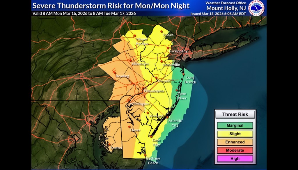
The weather service’s Storm Prediction Center updated its forecast overnight, putting the western portion of the Lehigh Valley, and areas to the west and south, at an “enhanced risk” of severe weather Monday. Areas to the east are at a lower, “slight risk,” according to the weather service.
There is “an increasing potential for strong to severe thunderstorms Monday along and ahead of a strong cold front,” the Storm Prediction Center noted. “Localized flash flooding will also be possible.”
Ahead of the cold front, winds are expected to pick back up later Sunday afternoon, gusting to 23 mph. Rain showers are then expected to move in late Sunday night. Temperatures, which are expected to reach the low 50s during the day, will dip only slightly tonight overnight to about 43.
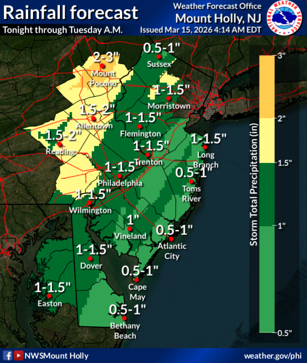
Conditions will deteriorate overnight as the high-energy system moves into the region from the southwest, carrying warm air that will push temperatures into the mid-60s Monday, but it will also carry “a deep moisture plume” that will fuel up to two inches of rainfall in the Lehigh Valley. Areas of Monroe and Carbon counties could see up to three inches of rain.
NWS X page
The Lehigh Valley could see up to two inches of rain beginning Sunday night, with higher precipitation amounts in the Poconos.
Along with the moisture, the system will bring significant instability through levels of the atmosphere, increasing the possibility of severe weather, including strong gusts, thunderstorms, and a low possibility of tornadic activity. Thunderstorms are possible anywhere from noon Monday through midnight. Winds will pick up during the late afternoon Monday, and stay strong through Tuesday morning.
Here is the complete forecast for the Lehigh Valley:
Sunday: Mostly cloudy, with a high near 52. Southeast wind 5 to 10 mph, with gusts as high as 25 mph.
Sunday night: Rain and possibly a thunderstorm before 5 a.m., then rain likely. Low around 43. East wind around 10 mph, with gusts as high as 20 mph. Chance of precipitation is 100%. New rainfall amounts between a tenth and quarter of an inch, except higher amounts possible in thunderstorms.
Monday: A chance of rain, then showers and possibly a thunderstorm after 8 a.m. Some of the storms could be severe. High near 67. Breezy, with a south wind 10 to 20 mph, with gusts as high as 30 mph. Chance of precipitation is 100%. New rainfall amounts between a half and three quarters of an inch possible.
Monday Night: Showers and possibly a thunderstorm. Some of the storms could be severe. Low around 29. Breezy, with a west wind 15 to 20 mph, with gusts as high as 35 mph. Chance of precipitation is 100%. New precipitation amounts between a half and three quarters of an inch possible.
Tuesday: A chance of showers before 8 a.m. Partly sunny, with a high near 38. West wind around 15 mph, with gusts as high as 30 mph. Chance of precipitation is 30%. Clearing overnight, with a low around 22.
Wednesday: Mostly sunny, with a high near 39, and a low around 27.
Thursday: Partly sunny, with a high near 49, and a low around 33.
Friday: Partly sunny, with a high near 54, low around 37 with a chance of rain. Chance of precipitation is 50%.
Saturday: A chance of rain. Partly sunny, with a high near 51. Chance of precipitation is 40%.