
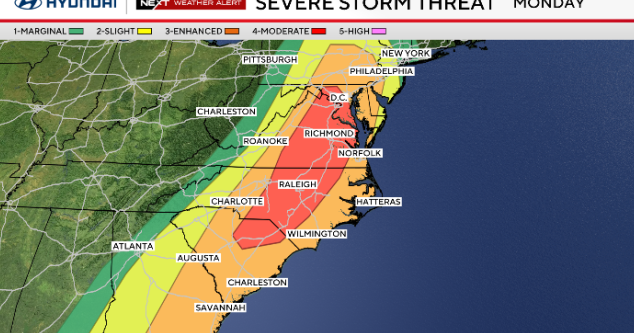
A strong cold front will move through Monday into the night, bringing the potential for strong to severe thunderstorms across the Philadelphia region. The main concern is damaging wind, but a few brief tornadoes and pockets of heavy rain that could cause localized flash flooding are also possible.
Even outside of storms, it will be windy with gusts around 35 to 45 mph, especially closer to the coast.
The greatest risk for severe weather looks to arrive late Monday afternoon through Monday evening as a line of storms develops along the approaching cold front. Some storms could produce damaging wind gusts and a brief tornado, especially if a few stronger cells form within the line.

CBS News Philadelphia
NEXT big weather changes
On Monday, gusty south winds push temperatures to the upper 60s and low 70s. It will be mostly cloudy with scattered showers and isolated rumbles in the morning.
Late Monday afternoon, an extremely strong cold front approaches, triggering pockets of heavy rain and severe storms during the evening.

CBS News Philadelphia
Significant threats include damaging straight-line winds of 50-70 mph, heavy rain with localized flooding and tornadoes. Behind the front, another blast of cold spreads across the region with a wintry mix and wet snow late Monday night.
Highs on Tuesday (St. Patrick’s Day) will be in the 30s with gusty winds, creating a wind chill in the 20s.
Here’s your 7-day forecast:

CBS News Philadelphia
Monday: NEXT Weather Alert for Storms. High 67, low 47.
Tuesday: NEXT Weather Alert for cold. High 42, low 32.
Wednesday: Partly cloudy. High 41, low 25.
Thursday: Partly cloudy. High 51, low 30.
Friday: Mostly sunny. High 57, low 37.
Saturday: Clouds, some sun. High 55, low 40.
Sunday: Maybe a shower? High 50, low 35.