
WIND ADVISORY: Gusts up to 50 mph possible in south-central Pennsylvania
WELL, TODAY COULD POTENTIALLY BE A VERY ACTIVE SEVERE WEATHER DAY. WE ARE IN AN ENHANCED RISK ISSUED BY THE STORM PREDICTION CENTER. THAT’S A THREE. ON A SCALE OF 1 TO 5. WE DON’T OFTEN SEE AN ENHANCED RISK ACROSS THE STATE ABOUT 5 TO 6 TIMES PER SEASON IS WHEN WE SEE THEM. STORMS. WE’RE LOOKING AT 12 TO 4 P.M. IN OUR WESTERN COUNTIES. THEY WILL BE MOVING IN. AND THEN AS WE HEAD TOWARDS DAUPHIN LIKE HARRISBURG, YORK AND YORK COUNTY, HANOVER, EASTERN ADAMS COUNTY, BETWEEN 4 AND 8 P.M. THAT’S WHEN YOU WANT TO KEEP AN EYE TO THE SKY AND THEN FURTHER TO THE EAST, A LITTLE CLOSER TO SEVEN, 8:00. WE COULD STILL HAVE THOSE STORMS MOVING THROUGH PARTS OF LEBANON COUNTY AND LANCASTER COUNTY. THE MAIN THREATS WITH THESE STORMS, THE HIGHEST THREAT WILL BE DAMAGING WINDS. AND WE’RE TALKING ABOUT THE POSSIBILITY OF STRAIGHT-LINE WINDS GREATER THAN 70MPH. THAT’S AS STRONG AS A WEAK TORNADO WITH 65MPH. SO THERE IS ALSO THE CHANCE FOR A FEW TORNADOES TO SPIN UP THIS AFTERNOON. LARGE HAIL WILL BE POSSIBLE AND LOCALLY HEAVY RAINFALL, WHICH COULD LEAD TO SOME PONDING ON ROADWAYS AND ALSO SOME LOW LYING MINOR FLOODING. BUT OVERALL FLOODING THREAT DOES APPEAR TO BE ON THE LOW SIDE. WE DO HAVE A WIND ADVISORY THAT GOES INTO EFFECT AT NOON TODAY, AND THAT’S FOR DAUPHIN, LEBANON, LANCASTER AND YORK COUNTIES UNTIL 11 P.M. THIS IS WHERE WINDS COULD GUST AS HIGH AS 50MPH. THIS IS IN ADDITION TO ANY WINDS FROM THUNDERSTORMS. SO IT IS GOING TO BE VERY WINDY DAY TODAY, ESPECIALLY IN OUR EASTERN COUNTIES. SO JUST KEEP THAT IN MIND. WE DO HAVE SOME LIGHT SHOWERS LIFTING UP THROUGH THE AREA RIGHT NOW. WE GET A LITTLE BIT OF A BREAK AHEAD OF THAT COLD FRONT THAT WILL COME THROUGH THIS AFTERNOON. THAT’S WHEN YOU’RE REALLY GOING TO WANT TO WATCH FOR THOSE STORMS. TEMPERATURES IN THE UPPER 60S WILL FALL VERY FAST. ONCE THAT FRONT MAKES ITS WAY THROUGH THE AREA. AND I’LL HAVE MORE ON THE
WIND ADVISORY: Gusts up to 50 mph possible in south-central Pennsylvania

Updated: 5:05 AM EDT Mar 16, 2026
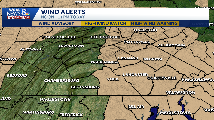
Strong winds are possible as strong to severe thunderstorms develop in south-central Pennsylvania on Monday. The National Weather Service issued a wind advisory for the following counties in the Susquehanna Valley, in effect from noon to 11 p.m. on Monday: DauphinLancasterLebanonYorkThe WGAL News 8 Storm Team also declared Monday an Alert Day, meaning the day features the threat of extreme, severe, and possibly life-threatening weather. What to expectSouth winds: 20 to 30 mphWind gusts: Up to 50 mphStrong, gusty winds are expected ahead of an approaching cold front. Scattered to numerous showers and thunderstorms will develop Monday afternoon and evening. Some storms could produce stronger localized wind gusts. Severe thunderstorm warnings may be needed if wind gusts exceed 58 mph, according to the National Weather Service. ImpactsUnsecured outdoor items may be blown aroundTree limbs could come downIsolated power outages are possiblePrecautionsUse extra caution while driving, especially in high-profile vehiclesSecure outdoor objects (trash cans, patio furniture, decorations, etc.)SOUTH-CENTRAL PA WEATHER RESOURCES: INTERACTIVE RADAR | ACTIVE WEATHER ALERTS | CURRENT CONDITIONS | HOURLY FORECAST | 10-DAY FORECAST | WEEKEND FORECAST | MAP ROOM | DOWNLOAD THE APP | WEATHER EMAILS
Strong winds are possible as strong to severe thunderstorms develop in south-central Pennsylvania on Monday.
The National Weather Service issued a wind advisory for the following counties in the Susquehanna Valley, in effect from noon to 11 p.m. on Monday:
DauphinLancasterLebanonYork

The WGAL News 8 Storm Team also declared Monday an Alert Day, meaning the day features the threat of extreme, severe, and possibly life-threatening weather.
What to expect
South winds: 20 to 30 mphWind gusts: Up to 50 mph

Strong, gusty winds are expected ahead of an approaching cold front. Scattered to numerous showers and thunderstorms will develop Monday afternoon and evening. Some storms could produce stronger localized wind gusts. Severe thunderstorm warnings may be needed if wind gusts exceed 58 mph, according to the National Weather Service. ImpactsUnsecured outdoor items may be blown aroundTree limbs could come downIsolated power outages are possible

PrecautionsUse extra caution while driving, especially in high-profile vehiclesSecure outdoor objects (trash cans, patio furniture, decorations, etc.)

SOUTH-CENTRAL PA WEATHER RESOURCES: INTERACTIVE RADAR | ACTIVE WEATHER ALERTS | CURRENT CONDITIONS | HOURLY FORECAST | 10-DAY FORECAST | WEEKEND FORECAST | MAP ROOM | DOWNLOAD THE APP | WEATHER EMAILS