
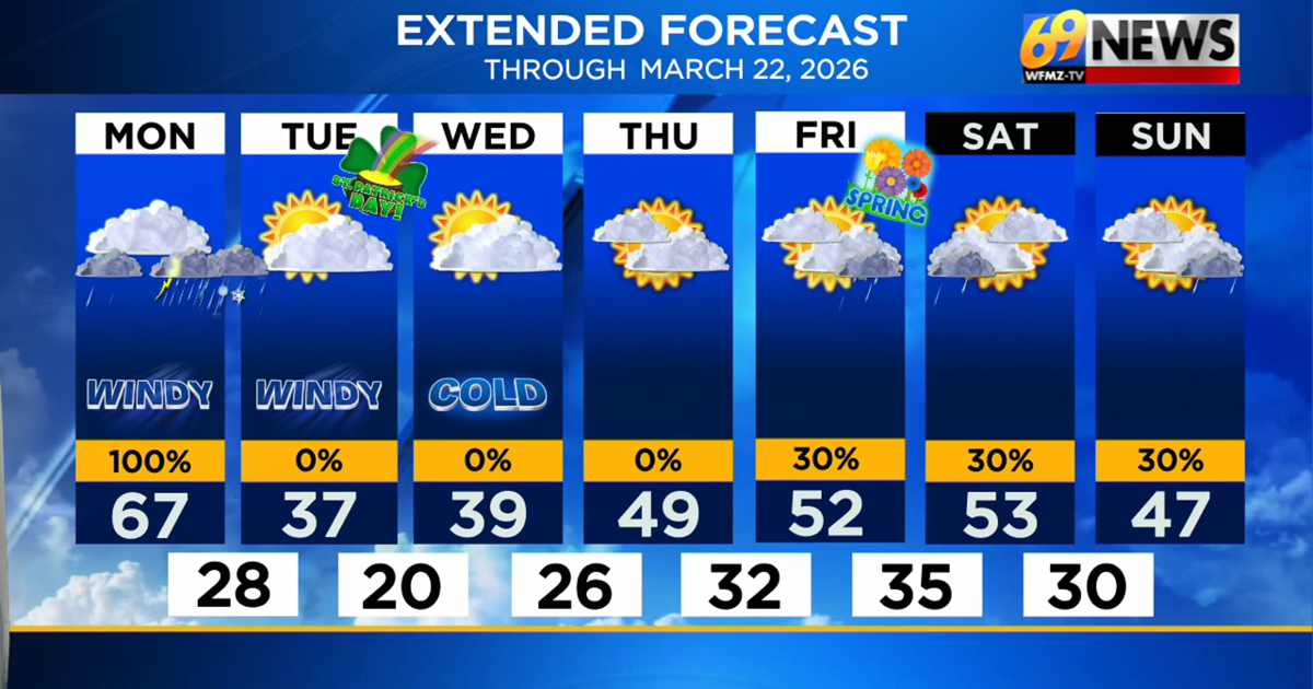
SHORT TERM FORECAST
TODAY: Breezy with rounds of showers and afternoon gusty thunderstorms (tornado potential in spots). High: 67
TONIGHT: Showers and gusty thunderstorm (tornado potential) through the evening; mostly cloudy and windy. Low: 28
TUESDAY: Mostly sunny, chilly and breezy. High: 37 Low: 20
_______________________________________________________________________________________________________________________________________________________________________________________________________________________________
FORECAST SUMMARY
A strong cold front is spreading rain at times today with gusty thunderstorms and a potential tornado late today and this evening. What may very well be the case is a severe squall line moving through later this afternoon and this evening, and that is the primary concern for severe weather. That squall line will have the potential to produce damaging wind gusts over 60mph, flooding downpours and a tornado. Severe storm chances blanket the entire area, but the chances are higher in Pennsylvania than in New Jersey, and are highest from much of the Lehigh Valley and especially points south and west. Once that strong cold front moves through, cold air rushes in, and any rain Monday night could end as some wet snow as a changeable March day comes to a close. So after a potentially wild Monday weather-wise, Tuesday and Wednesday look brighter and drier, albeit unseasonably cold with highs only in the 30s. Gusty winds linger into Tuesday, and keep wind chills below freezing all day. By the end of the week, and the official start of spring on Friday, the cold eases, and a seasonably cool and mostly dry stretch of weather will take us into the new season.
DETAILED FORECAST
MONDAY
A strong cold front will approach later Monday, with a southerly surge of warmth, wind, and rain out ahead of it. Monday will be a cloudy and windy day with scattered showers likely for much of the day, but not necessarily an all-day rain. It will also be warm despite the wet weather, the warmest day of the forecast by far as highs surge to around 65-70 degrees by later in the day. In addition, dynamics will be in place for the potential of some gusty severe t-storms as the Storm Prediction Center has highlighted the entire region under at least a slight risk for severe weather (level 2 out of 5) with an enhanced risk (level 3 out of 5) from much of the Lehigh Valley and points south and west. Damaging straight-line winds will be the biggest threat with any t-storm later Monday, with wind gusts over 60mph possible, but a few tornadoes can also not entirely be ruled out. We could also potentially see a case where there is one strong line of storms that blasts through either side of sunset late Monday (4pm to 10pm) with the severe threat mostly coming all at once as the line moves through. 1 to locally 2 inches of rain will be possible from the event, leading to some localized flooding where heavier downpours persist. And to complete a day full of meteorological “March madness”, colder air will rush in Monday night, low temperatures should plummet all the way down to the upper 20s, and rain and severe storms could end as a brief period of wet snow. Factor in winds potentially gusting up to 40mph, and wind chills will eventually dip down into the teens! It will be quite the shocker again when you wake up Tuesday morning!
TUESDAY AND WEDNESDAY
The “luck of the Irish” isn’t on our side weather-wise this year, as an unseasonably cold and breezy (but dry) St. Patrick’s Day looks to be in store for Tuesday. Look for partly sunny skies, but a much colder day with highs only in the mid to upper 30s, with wind chills below freezing all day. Wednesday will be a similar day with a very cold start first thing in the morning around 20 degrees followed by afternoon high temperatures only in the upper 30s to near 40 degrees. Fortunately, with high pressure building in, Wednesday should have lighter winds and not as blustery of conditions like Tuesday.
THURSDAY AND FRIDAY
We’ll round out the week on a milder note with Thursday looking to stay dry but a bit on the cloudier side with light winds and high temperatures back closer to normal in the upper 40s to around 50 degrees. The Spring Equinox arrives Friday, and while it won’t feel like the big warmth we recently experienced, we can expect close to normal high temperatures in the low 50s. It will be a mostly cloudy day and some showers can’t entirely be ruled out late, although much of Friday looks dry at this time.
TRACK THE WEATHER:
LINKS: HOUR BY HOUR | RADAR | TRAFFIC