
The National Weather Service in State College, PA has issued a severe thunderstorm warning for eastern Adams County in south-central Pennsylvania and western York County in south-central Pennsylvania.This warning is in effect until 12:30 PM EDT.At 11:55 AM EDT, severe thunderstorms were located along a line extending from Lake Heritage to Taneytown to near Westminster, moving northeast at 65 mph.Hazard: 60 mph wind gusts. Source: Radar indicated. Impact: Expect damage to roofs, siding, and trees.Locations impacted include York, Lower Allen, Hanover, Weigelstown, Gettysburg, Parkville, Spry, Hampton, Shiloh, East York, Stonybrook-Wilshire, and West York.Radar has indicated rotation within these severe thunderstorms. Although a tornado is not immediately likely, tornadoes can develop quickly during severe thunderstorms.This includes the following interstates: The Pennsylvania Turnpike from mile markers 239 to 245, and Interstate 83 from mile markers 13 to 39.Precautionary/preparedness actions: Stay inside a well-built structure and keep away from windows.To report severe weather, contact your nearest law enforcement agency. They will send your report to the National Weather Service office in State College, PA.Very heavy rainfall is occurring with these severe thunderstorms and may lead to flash flooding. Do not drive your vehicle through flooded roadways.Watches vs warningsKnowing the difference between severe watches and warnings is crucial to helping you and your family stay safe before and during severe weather.A watch means ingredients are in place for severe weather to develop. This means severe weather could happen, and you should have a plan ready in case severe weather develops later in the day.A warning means severe weather is happening, and you need to take action now to protect yourself, others and your property.In addition to watches and warnings, there are outlooks that can be issued days in advance. Different threat levels are given to different areas.
The National Weather Service in State College, PA has issued a severe thunderstorm warning for eastern Adams County in south-central Pennsylvania and western York County in south-central Pennsylvania.
This warning is in effect until 12:30 PM EDT.
At 11:55 AM EDT, severe thunderstorms were located along a line extending from Lake Heritage to Taneytown to near Westminster, moving northeast at 65 mph.
Hazard: 60 mph wind gusts. Source: Radar indicated. Impact: Expect damage to roofs, siding, and trees.
Locations impacted include York, Lower Allen, Hanover, Weigelstown, Gettysburg, Parkville, Spry, Hampton, Shiloh, East York, Stonybrook-Wilshire, and West York.
Radar has indicated rotation within these severe thunderstorms. Although a tornado is not immediately likely, tornadoes can develop quickly during severe thunderstorms.
This includes the following interstates: The Pennsylvania Turnpike from mile markers 239 to 245, and Interstate 83 from mile markers 13 to 39.
Precautionary/preparedness actions: Stay inside a well-built structure and keep away from windows.
To report severe weather, contact your nearest law enforcement agency. They will send your report to the National Weather Service office in State College, PA.
Very heavy rainfall is occurring with these severe thunderstorms and may lead to flash flooding. Do not drive your vehicle through flooded roadways.
Watches vs warnings
Knowing the difference between severe watches and warnings is crucial to helping you and your family stay safe before and during severe weather.
A watch means ingredients are in place for severe weather to develop. This means severe weather could happen, and you should have a plan ready in case severe weather develops later in the day.
A warning means severe weather is happening, and you need to take action now to protect yourself, others and your property.
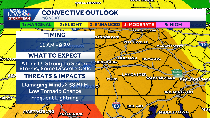
In addition to watches and warnings, there are outlooks that can be issued days in advance. Different threat levels are given to different areas.