
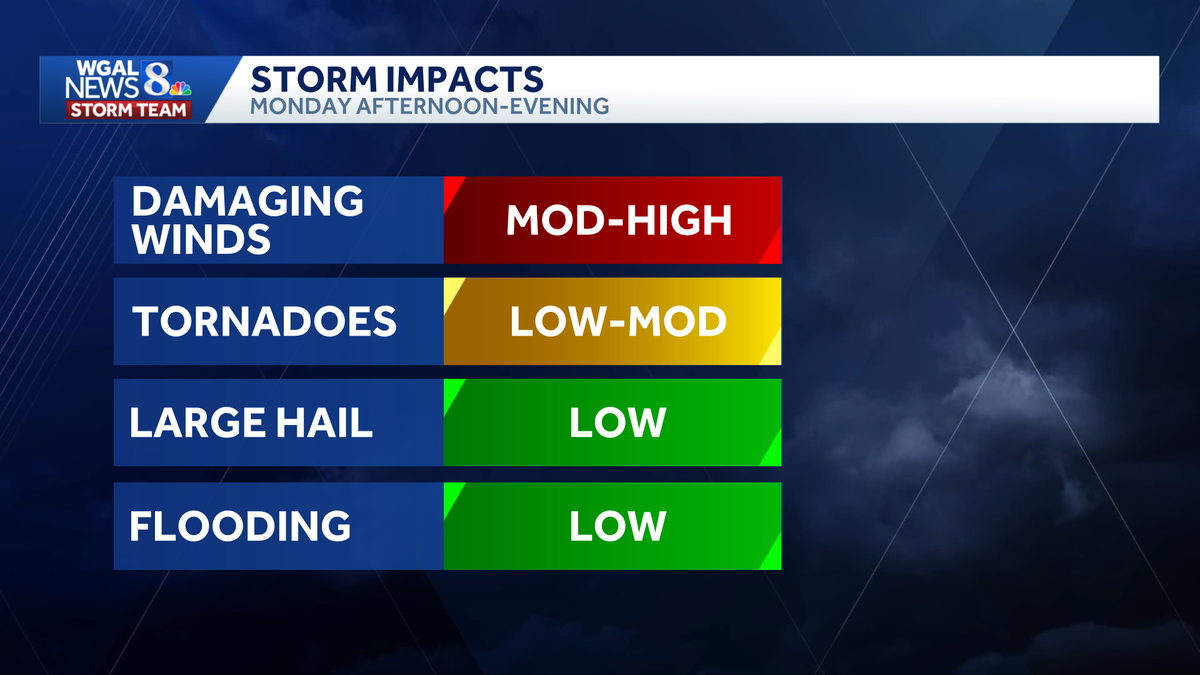
WELL, TODAY COULD POTENTIALLY BE A VERY ACTIVE SEVERE WEATHER DAY. WE ARE IN AN ENHANCED RISK ISSUED BY THE STORM PREDICTION CENTER. THAT’S A THREE. ON A SCALE OF 1 TO 5. WE DON’T OFTEN SEE AN ENHANCED RISK ACROSS THE STATE ABOUT 5 TO 6 TIMES PER SEASON IS WHEN WE SEE THEM. STORMS. WE’RE LOOKING AT 12 TO 4 P.M. IN OUR WESTERN COUNTIES. THEY WILL BE MOVING IN. AND THEN AS WE HEAD TOWARDS DAUPHIN LIKE HARRISBURG, YORK AND YORK COUNTY, HANOVER, EASTERN ADAMS COUNTY, BETWEEN 4 AND 8 P.M. THAT’S WHEN YOU WANT TO KEEP AN EYE TO THE SKY AND THEN FURTHER TO THE EAST, A LITTLE CLOSER TO SEVEN, 8:00. WE COULD STILL HAVE THOSE STORMS MOVING THROUGH PARTS OF LEBANON COUNTY AND LANCASTER COUNTY. THE MAIN THREATS WITH THESE STORMS, THE HIGHEST THREAT WILL BE DAMAGING WINDS. AND WE’RE TALKING ABOUT THE POSSIBILITY OF STRAIGHT-LINE WINDS GREATER THAN 70MPH. THAT’S AS STRONG AS A WEAK TORNADO WITH 65MPH. SO THERE IS ALSO THE CHANCE FOR A FEW TORNADOES TO SPIN UP THIS AFTERNOON. LARGE HAIL WILL BE POSSIBLE AND LOCALLY HEAVY RAINFALL, WHICH COULD LEAD TO SOME PONDING ON ROADWAYS AND ALSO SOME LOW LYING MINOR FLOODING. BUT OVERALL FLOODING THREAT DOES APPEAR TO BE ON THE LOW SIDE. WE DO HAVE A WIND ADVISORY THAT GOES INTO EFFECT AT NOON TODAY, AND THAT’S FOR DAUPHIN, LEBANON, LANCASTER AND YORK COUNTIES UNTIL 11 P.M. THIS IS WHERE WINDS COULD GUST AS HIGH AS 50MPH. THIS IS IN ADDITION TO ANY WINDS FROM THUNDERSTORMS. SO IT IS GOING TO BE VERY WINDY DAY TODAY, ESPECIALLY IN OUR EASTERN COUNTIES. SO JUST KEEP THAT IN MIND. WE DO HAVE SOME LIGHT SHOWERS LIFTING UP THROUGH THE AREA RIGHT NOW. WE GET A LITTLE BIT OF A BREAK AHEAD OF THAT COLD FRONT THAT WILL COME THROUGH THIS AFTERNOON. THAT’S WHEN YOU’RE REALLY GOING TO WANT TO WATCH FOR THOSE STORMS. TEMPERATURES IN THE UPPER 60S WILL FALL VERY FAST. ONCE THAT FRONT MAKES ITS WAY THROUGH THE AREA. AND I’LL HAVE MORE ON THE
The National Weather Service has issued a tornado watch in effect until 7 p.m. Monday for the following areas in Pennsylvania.This watch includes 16 counties: AdamsColumbiaCumberlandDauphinFranklinJuniataLancasterLebanonMifflinMontourNorthumberlandPerrySchuylkillSnyderUnionYorkThis includes the cities of Berwick, Bloomsburg, Carlisle, Chambersburg, Danville, Gettysburg, Harrisburg, Hershey, Lancaster, Lebanon, Lewisburg, Lewistown, Mifflintown, Newport, Pottsville, Selinsgrove, Shamokin, Sunbury, Waynesboro, and York.Watches vs warningsKnowing the difference between severe watches and warnings is crucial to helping you and your family stay safe before and during severe weather.A watch means ingredients are in place for severe weather to develop. This means severe weather could happen, and you should have a plan ready in case severe weather develops later in the day.A warning means severe weather is happening, and you need to take action now to protect yourself, others and your property.In addition to watches and warnings, there are outlooks that can be issued days in advance. Different threat levels are given to different areas.Ready, get set, goREADY | If your town is in a severe outlook, be ready. Pay attention to the forecast in the coming hours and days, as severe weather may be possible.GET SET | If a severe weather watch is issued for your town, that means ingredients are present for severe weather to occur. Severe weather is going to be possible.GO | A severe warning has been issued. That means severe weather is happening now. Take cover.WGAL weather linksWatch it: Use WGAL’s interactive radar to track storms.Get alerts that follow you: Turn on location-based weather alerts with WGAL’s step-by-step instructions.Check what’s closed: See closings and delays for businesses, churches, and organizations during severe weather.Navigate smarter: Open WGAL’s interactive traffic map for crashes, construction, and road closures—with traffic cameras.Inbox updates: Sign up for email alerts, from daily forecasts to severe-weather warnings.Plan by the hour: View the hour-by-hour forecast for your day.Weekend ready: Preview the weekend forecast before you lock in plans.Look ahead: Browse the 10-day forecast for the extended outlook.
The National Weather Service has issued a tornado watch in effect until 7 p.m. Monday for the following areas in Pennsylvania.
This watch includes 16 counties:
AdamsColumbiaCumberlandDauphinFranklinJuniataLancasterLebanonMifflinMontourNorthumberlandPerrySchuylkillSnyderUnionYork
This includes the cities of Berwick, Bloomsburg, Carlisle, Chambersburg, Danville, Gettysburg, Harrisburg, Hershey, Lancaster, Lebanon, Lewisburg, Lewistown, Mifflintown, Newport, Pottsville, Selinsgrove, Shamokin, Sunbury, Waynesboro, and York.
Watches vs warnings
Knowing the difference between severe watches and warnings is crucial to helping you and your family stay safe before and during severe weather.
A watch means ingredients are in place for severe weather to develop. This means severe weather could happen, and you should have a plan ready in case severe weather develops later in the day.
A warning means severe weather is happening, and you need to take action now to protect yourself, others and your property.
In addition to watches and warnings, there are outlooks that can be issued days in advance. Different threat levels are given to different areas.
Ready, get set, go
READY | If your town is in a severe outlook, be ready. Pay attention to the forecast in the coming hours and days, as severe weather may be possible.
GET SET | If a severe weather watch is issued for your town, that means ingredients are present for severe weather to occur. Severe weather is going to be possible.
GO | A severe warning has been issued. That means severe weather is happening now. Take cover.
WGAL weather links