

The National Weather Service has issued a Tornado Watch for the entire area until 7pm tonight. A watch means things are favorable for tornadoes to form.

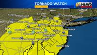
We continue to monitor an elevated threat for severe thunderstorms for this Monday afternoon into evening. You will want to stay weather aware for the possibility for severe thunderstorms, which can deliver damaging winds, heavy rain which could lead to localized flash flooding, and even a tornado or two across parts of the area.
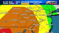
The Storm Prediction Center(SPC) continues to paint some of our region, mostly from the Lehigh Valley points south and west, under an “enhanced” risk for severe storms. That’s a “3” on a 1 to 5 scale for the potential for severe weather, with 5 being the highest. Keep in mind that our part of the country rarely ever sees a 5, or high risk for severe storms, as that is usually reserved for intense severe weather outbreaks in the Plains or Deep South.
So, the enhanced risk for severe weather highlights a fairly sizable chance for a few gusty storms, and a relatively early-in-the-season chance as well. Usually, our highest severe weather threats are more likely in the spring and summer, from later May through early August.
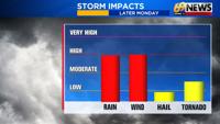
Here’s a quick breakdown of the possible severe weather outbreak:
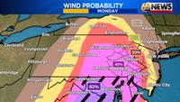
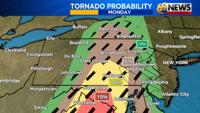
WHAT: Damaging winds are the primary concern from any severe storms that develop. Strong storms will have the potential for wind gusts of at least 60mph. There is also the chance for a few “supercell” thunderstorms that could generate a brief tornado or two. This is more of a localized threat than the widespread straight-line wind potential. Hail is less of a concern, but still possible in a stronger storm. Any thunderstorm, severe or not, is capable of producing heavy rain, with 1 to 2 inches of rain and localized flooding a possibility as well.
WHEN: A thunderstorm or two will also be possible throughout the day today. Some of these storms could be severe but the threat for more widespread significant severe weather with damaging winds and a tornado risk will be mainly late Monday afternoon into the evening…or roughly 4pm to 10pm. During that time period a line of storms is expected to move from west to east along a strong cold front.
WHERE: Severe storms are possible area-wide, but the chances will be highest in eastern Pennsylvania, lower in western New Jersey, and lowest closer to the shore. Areas from the Lehigh Valley, Berks County, and the Delaware Valley points west will have the highest severe weather potential, mainly areas highlighted in orange in the “enhanced” risk area by the Storm Prediction Center.
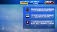
WHY: A strong cold front will deliver rain, the severe storm potential, strong winds, and even some wet snow at the end as colder air rushes in. Because of the strong nature of this front and the right ingredients for severe storms to form, Monday is a day you’ll definitely want to stay weather aware.
Be sure to download the 69News StormCenter App for your mobile phone. It’s free and is a great way to stay weather aware, with current radars, warning alerts when severe weather threatens, and the latest forecasts from the 69News team of meteorologists.