
Western PA: Freeze Warning in effect for Saturday morning
Two nights of freezing temperatures are possible this weekend.
A WEEKEND IS HERE, AND THE WEEKEND WILL BE A LITTLE BETTER THAN WHAT WE’VE SEEN FOR MOST OF THIS WEEK. IT’S GOING TO BE CHILLY IN THE MORNINGS, AND WE’LL STILL SEE A LITTLE BIT OF A CHILL IN THE AFTERNOON AS WELL, BUT WE’RE GOING TO BE REALLY COLD THE NEXT COUPLE OF MORNINGS, AND WE DO HAVE FREEZE WARNINGS IN EFFECT TONIGHT. WE’LL LIKELY SEE THAT AGAIN TOMORROW NIGHT AS WELL. SUNSHINE WILL START RETURNING AS WELL AND THE WIND BACKS OFF JUST A BIT SO WON’T FEEL QUITE AS COLD AS IT HAS BEEN. WE DO HAVE A FREEZE WARNING IN EFFECT STARTING AT MIDNIGHT. THIS GOES UNTIL 9:00 TOMORROW MORNING FOR WESTMORELAND, ALLEGHENY, BEAVER, WASHINGTON, GREENE, FAYETTE, MONONGALIA AND PRESTON COUNTIES. THESE SPOTS, ESPECIALLY OUTSIDE OF THE CITY OF PITTSBURGH, HAVE THE BEST CHANCE TO DROP TO THE FREEZING MARK TONIGHT. AND FOR MANY OF US, THIS WILL BE THE FIRST TIME THIS SEASON WE ACTUALLY GET THERE. STILL A SMATTERING OF LIGHT RAIN SHOWERS HERE ON RADAR AS WELL. NOT AS BAD AS WE’VE SEEN, BUT A QUICK SPRINKLE HERE OR THERE. THESE SHOULD FIZZLE OFF OVER THE COURSE OF THE NEXT FEW HOURS. WE SHOULD BE DRY BY THE TIME HIGH SCHOOL FOOTBALL GAMES KICK OFF A LITTLE LATER ON THIS EVENING AT 7:00. 55 IS WHERE WE MAKE TOMORROW. LOOK AT OUR START TEMPERATURE THOUGH 36 TOMORROW 37 SUNDAY AND MONDAY MORNING, SO STILL COULD SEE FROST OR FREEZE CONCERNS THE NEXT FEW MORNINGS. 56 ON SUNDAY IS LIKELY THE WARMEST DAY OF THE NEXT WEEK. NO BIG WARMING TRENDS COMING ANYTIME SOON. WE’LL SEE SUNSHINE ON MONDAY BEFORE CLOUDS INCREASE ON TUESDAY, AND THEN WE’LL WATCH FOR SHOWER CHANCES POSSIBLE WEDNESDAY, THURSDAY AND FRIDAY. RIGHT NOW, NO ONE DAY LOOKS LIKE A WASHOUT AND IT DOES LOOK LIKE WE SHOULD GENERALLY BE DRY FOR TRICK OR TREATERS, BUT WE’RE WATCHING FRIDAY VERY CLOSELY AND THEN WE GET EVEN COOLER NEXT WEEKEND. THE FIRST WEEKEND OF NOVEMBER. NOVEMBER STARTS NEXT SATURDAY. THE HIGH TEMPERATURES STRUGGLING AGAIN TO 50 DEGREES. SO IF YOU’RE HEADING OUT TO HIGH SCHOOL FOOTBALL TONIGHT, BUNDLE UP. WE’LL BE IN THE 40S FOR GAMES AREA WIDE WITH CLOUDS WITH US AS WE START, WE MAY SHED SOME OF THOSE CLOUDS, ESPECIALLY SOUTH OF THE CITY, AS WE HEAD THROUGH THE GAMES TOMORROW FOR PITT’S HOMECOMING GAME AGAINST NC STATE. TAILGATING ABOUT 50 DEGREES 54 AROUND. KICKOFF IN THE STEELER GAME LOOKS NICE AS WELL. TAILGATE TEMPERATURE 56, ABOUT 51. BY THE TIME WE GET TO KICKOFF, SO NOT TOO BAD FOR US. IT FEELS LIKE FOOTBALL CLOUDS OVERHEAD ON ACTION CAM. THERE’S STILL A LIGHT BREEZE. WINDSOR WEST NORTHWEST AT 1449 IS THE CURRENT TEMPERATURE AT THE AIRPORT. NO WIND GUSTS THOUGH REALLY TO WORRY ABOUT. IT’S JUST BREEZY OUT THERE. TEMPERATURES DROP INTO THE 30S TONIGHT. MIDDLE
Western PA: Freeze Warning in effect for Saturday morning
Two nights of freezing temperatures are possible this weekend.

Updated: 4:26 PM EDT Oct 24, 2025
As skies begin to clear, temperatures will drop close to freezing for many locations this weekend for the first time this season. We stay dry until the middle of next week.Freeze Warning tonightWith some clearing skies expected tonight, a Freeze Warning is in effect for Saturday from midnight to 9 a.m. for Allegheny, Beaver, Greene, Fayette, Monongalia, Preston, Washington, and Westmoreland counties. We could see another round of Freeze Warnings for Sunday morning.Chilly but Dry WeekendWinds will die down this weekend as sunshine returns. Despite more sunshine, temperatures will only return to the middle 50s. Those will be the temperatures you can expect for the Pitt game and for tailgating for the Steelers game. The Steelers game will be played mainly in the 40s.No real warm up in sight A cooler than normal trend persists through the end of October. The weekend sunshine won’t last long as another system will roll in for the middle of next week. Showers are possible late Tuesday and Wednesday. We are continuing to monitor the trick-or-treat forecast. As of now, a few showers could linger into early Friday but we should dry out for all the ghosts and goblins on Halloween night. TONIGHT: Partly cloudy with a light freeze. Low: 36°.SATURDAY: Frosty start then partly to mostly cloudy. High: 55°, low: 37°.SUNDAY: Another frosty start with partly cloudy skies. High: 56°, low: 38°.
PITTSBURGH —
As skies begin to clear, temperatures will drop close to freezing for many locations this weekend for the first time this season. We stay dry until the middle of next week.
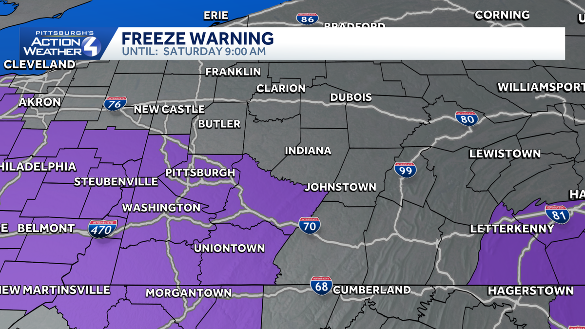
Freeze Warning tonight
With some clearing skies expected tonight, a Freeze Warning is in effect for Saturday from midnight to 9 a.m. for Allegheny, Beaver, Greene, Fayette, Monongalia, Preston, Washington, and Westmoreland counties. We could see another round of Freeze Warnings for Sunday morning.

Hearst Owned
Freeze Warning for locations along and south of the Turnpike for Saturday morning.
Chilly but Dry Weekend
Winds will die down this weekend as sunshine returns. Despite more sunshine, temperatures will only return to the middle 50s. Those will be the temperatures you can expect for the Pitt game and for tailgating for the Steelers game. The Steelers game will be played mainly in the 40s.

Hearst Owned
Sun and clouds for tailgating with the game mainly in the 40s on Sunday.
No real warm up in sight
A cooler than normal trend persists through the end of October. The weekend sunshine won’t last long as another system will roll in for the middle of next week. Showers are possible late Tuesday and Wednesday. We are continuing to monitor the trick-or-treat forecast. As of now, a few showers could linger into early Friday but we should dry out for all the ghosts and goblins on Halloween night.

Hearst Owned
We keep the November feel as we end October.
TONIGHT: Partly cloudy with a light freeze. Low: 36°.
SATURDAY: Frosty start then partly to mostly cloudy. High: 55°, low: 37°.
SUNDAY: Another frosty start with partly cloudy skies. High: 56°, low: 38°.