
Evening Showers & Mild Start To Spring In South Central Pennsylvania
As spring approaches, temperatures are warming; expect highs in the 60s this weekend.
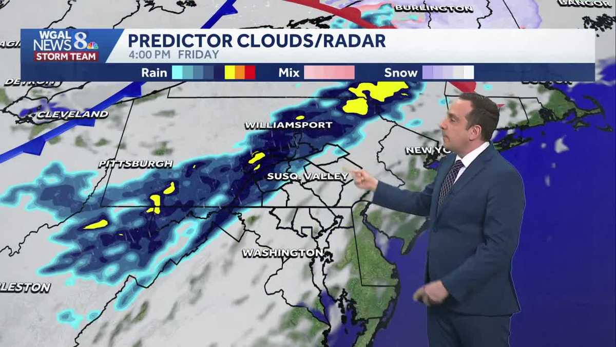
HAPPEN FROM MARCH 29TH THROUGH APRIL 1ST. AND HOPEFULLY WE’LL HAVE SOME NICE WEATHER. GO FOR A RUN OR BIKE RIDE. ABSOLUTELY. NEED MORE SPRING WEATHER TO COME WITH THIS SIGN OF SPRING THERE. THAT’S RIGHT. WE ARE GOING TO GET A TASTE OF SPRING LIKE WARMTH AS WE GO ON INTO THE WEEKEND. THERE WILL BE SOME COOLER WEATHER, BUT NO ARCTIC AIR SHOTS LIKE WE HAVE SEEN FOR THE FIRST PART OF MARCH. SO SPRING LIKE FOR THE START OF SPRING. TOMORROW IT IS GOING TO BE WARMER TOMORROW. I DO EXPECT THE RETURN OF SCATTERED SHOWERS AS WE GET CLOSER TO THE EVENING RUSH HOUR. IT LOOKS LIKE THE WEEKEND AHEAD IS GOING TO BE WARM AND MAINLY DRY. IT’S JUST WE HAVE HIGHER CHANCES FOR SHOWERS LATE IN THE EVENING. SUNDAY ON INTO SUNDAY NIGHT. AND THEN AS THAT STORM PULLS AWAY FROM US EARLY IN THE WEEK, I DO EXPECT COLDER WEATHER WILL BE AROUND EARLY NEXT WEEK AND IT’S GOING TO BE BREEZY AS WELL. BUT AGAIN, TEMPERATURES WILL BE CLOSER TO AVERAGE. INSTEAD OF FEELING LIKE FEBRUARY, LIKE WHAT WE HAD TO DEAL WITH EARLIER THIS WEEK. TAKING A LIVE LOOK RIGHT NOW OVER CARLISLE, EPHRATA, GETTYSBURG AND HERSHEY, IT SEEMS DRY. CALM OUT THERE, BUT NOT FOR EVERYBODY ON THE STORM TEAM LIVE RADAR NETWORK. WE ARE TRACKING A FEW SPOTTY SHOWERS. BULK OF WHAT YOU’RE SEEING HERE IS NOT EVEN REACHING THE GROUND. BUT WE DO HAVE SOME SHOWERS RIGHT NOW IN PARTS OF PERRY COUNTY INTO DAUPHIN COUNTY, LEBANON COUNTY, POSSIBLY EVEN A FEW ISOLATED SHOWERS UP THERE INTO JUNIATA COUNTY. SO PARTLY CLOUDY, SEASONABLY CHILLY, JUST A FEW SPOTTY SHOWERS EARLY TONIGHT. TEMPERATURES WILL BOTTOM OUT IN THE LOW TO MID 30S. THAT’S WHERE WE SHOULD BE FOR MID TO LATE MARCH. I DO EXPECT THOUGH, TEMPERATURES WILL START WARMING QUICKLY AS WE GO ON IN THROUGH THE MORNING. AND THEN WE’LL TOP OFF IN THE LOW TO MID 60S. IT’S ONCE WE GET CLOSER TO THE EVENING RUSH HOUR, SHOWER, CHANCES WILL START TO RISE AND STAY UP AFTER SUNSET ON INTO THE OVERNIGHT HOURS. THE HIGHEST CHANCES WILL BE DURING THE LATE EVENING HOURS TOMORROW, THEN HEADING INTO THE WEEKEND MAY SEE A FEW STRAY SHOWERS NEAR DAWN. BUT I DO BELIEVE MOST, IF NOT ALL OF THE VALLEY IS GOING TO BE DRY THROUGHOUT SATURDAY. SUNDAY STARTS OFF DRY. IT’S JUST. ONCE WE GET CLOSER TO EVENING ON SUNDAY, THE SHOWER CHANCES START GOING BACK UP, BUT WE’RE STAYING COMFORTABLE. SPRING LIKE FOR YOUR SATURDAY WITH HIGHS NEAR 60 DEGREES. A LITTLE BIT WARMER ON SUNDAY WITH HIGHS CLOSER TO 70. MADE IT TO 52 TODAY. AFTER WE START THE DAY OFF AT 33. RIGHT ON PAR FOR THIS DATE. WE’RE STILL AT 44 RIGHT NOW IN HARRISBURG 41. IF YOU’RE JOINING US FROM LANCASTER AND 46 CURRENTLY IN GETTYSBURG, YOU CAN SEE THAT SPRING LIKE WARMTH EXTENDS ALL THE WAY UP INTO THE UPPER PLAINS. IT’S NEAR THE CANADIAN LINE. AND NORTH DAKOTA LINE IS WHERE WE ARE SEEING OUR NEXT CLIPPER SYSTEM THAT’S GOING TO CROSS OVER THE GREAT LAKES REGION TOMORROW, AND THEN BE ON OUR DOORSTEP BY THE TIME WE GET CLOSER TO DINNER TIME. SO WATCH WHAT HAPPENS HERE ON THE PREDICTOR. SOME BREAKS IN THE CLOUDS THROUGH THE NIGHT. TONIGHT WE’LL HAVE SOME SUNSHINE TO START OUR FRIDAY, BUT CLOSER TO DINNER TIME. THE EVENING RUSH. HERE COMES A ROUND OF SOME SHOWERS, MOST LIKELY AFTER SUNSET UNTIL ROUGHLY ABOUT MIDNIGHT. BUT THIS COLD FRONT IS GOING TO COME THROUGH JUST AROUND DAWN. THAT COULD TRIGGER AN ISOLATED SHOWER, BUT CHANCES ARE QUITE LOW OF THAT. THE DRIER AIR BACK BEHIND THAT FRONT WILL ALLOW FOR MORE SUNSHINE, AND TEMPERATURES WILL BOUNCE BACK TO NEAR 60 DEGREES FOR OUR HIGHS AND THEN HEADING ON INTO SUNDAY, YOU CAN SEE WE’LL HAVE MORE CLOUDS AROUND, BUT IT IS GOING TO BE A WARM DAY OUT THERE. MOST OF OUR SUNDAY IS GOING TO BE DRY. IT’S SUNDAY NIGHT. HERE COME THE CHANCES FOR SOME RAIN SHOWERS, PERHAPS EVEN A FEW ISOLATED THUNDERSHOWERS THROWN INTO THE MIX. BUT THEN THIS COLD FRONT WILL MOVE ON THROUGH AND THIS WILL DROP TEMPERATURES FOR EARLY NEXT WEEK. SO CERTAINLY FEELING LIKE SPRING FOR THE START OF SPRING AGAIN, THE SHOWER CHANCES WILL BE HIGHEST FOR SUNDAY NIGHT ON INTO VERY EARLY MONDAY MORNING. AND THEN NOTICE TEMPERATURES DIP BACK DOWN INTO THE 40S FOR HIGHS FOR MONDAY TO TUESDAY. WE’RE BACK INTO THE 50S WITH SEASONABLE WEATHER FOR YOUR WEDNESDAY AND THE
Evening Showers & Mild Start To Spring In South Central Pennsylvania
As spring approaches, temperatures are warming; expect highs in the 60s this weekend.

Updated: 10:26 PM EDT Mar 19, 2026
Good evening,Besides a stray shower, it will be a dry and seasonably chilly evening as temperatures remain in the 40s. Overnight tonight, lows will fall to 32 degrees under partly cloudy skies.Clouds will increase on Friday for the first day of spring, and temperatures will be warmer, in the upper 50s. A weak cold front will produce scattered showers Friday evening through sunrise Saturday. Rain totals will range from a few hundredths of an inch to around 0.20″.WARMER WEEKEND:After morning clouds clear Saturday, look for plentiful sunshine and pleasant highs near 60. Sunday will feature increasing clouds and warmer highs in the upper 60s. Showers are possible late Sunday, as a cold front approaches.NEXT WEEK:After the front passes early Monday, highs will fall to the mid-40s, and it will be breezy. Highs will hover in the upper 40s on Tuesday, then reach 52 degrees on Wednesday.Temperatures climb to the upper 50s on Thursday, then a chance of showers returns Friday, followed by a cool down for the upcoming weekend.Have a great day!
Good evening,
Besides a stray shower, it will be a dry and seasonably chilly evening as temperatures remain in the 40s. Overnight tonight, lows will fall to 32 degrees under partly cloudy skies.
Clouds will increase on Friday for the first day of spring, and temperatures will be warmer, in the upper 50s. A weak cold front will produce scattered showers Friday evening through sunrise Saturday. Rain totals will range from a few hundredths of an inch to around 0.20″.
WARMER WEEKEND:
After morning clouds clear Saturday, look for plentiful sunshine and pleasant highs near 60. Sunday will feature increasing clouds and warmer highs in the upper 60s. Showers are possible late Sunday, as a cold front approaches.
NEXT WEEK:
After the front passes early Monday, highs will fall to the mid-40s, and it will be breezy. Highs will hover in the upper 40s on Tuesday, then reach 52 degrees on Wednesday.
Temperatures climb to the upper 50s on Thursday, then a chance of showers returns Friday, followed by a cool down for the upcoming weekend.
Have a great day!