
Pittsburgh: Severe Weather Alert Day Sunday
Thunderstorms could become strong to severe late in the day.
FOR THE SECOND PART OF SUNDAY. AND REALLY, AS WE GET CLOSER TO SUNSET, WE’RE WATCHING TOMORROW, JUST PARTLY SUNNY SKIES WILL BE COMFORTABLE, WILL CLIMB TO ABOUT 60. THAT’S SLIGHTLY COOLER THAN WHERE WE MADE IT TODAY. THEN OUR SEVERE WEATHER ALERT DAY ON SUNDAY AS WE WATCH FOR STORMS AGAIN, MAINLY LATE IN THE DAY. SO UNTIL ABOUT 4 OR 5:00 YOU’LL BE FINE. AFTER THAT, WE START OPENING THAT WINDOW OF OPPORTUNITY FOR STORMS TO DEVELOP, AND THEN WE WILL BE COOLER AS RAIN SHOWERS TAPER OFF. HEADING INTO YOUR MONDAY MORNING, THE LAST BIT OF SHOWERS AND THUNDERSTORMS ARE EXITING NOW. ONE CLUSTER HERE, JUST EXITING OUT OF LIGONIER, SLIDING DOWN ROUTE 30, MOVING INTO SOMERSET COUNTY AND ALONG 271. THE OTHER CLUSTER MOVING THROUGH PORTIONS OF FAYETTE COUNTY, NOW EXITING OUT OF WASHINGTON, REIGNING OVER TOP OF CALIFORNIA. BROWNSVILLE DOWN ALONG THE MON VALLEY AS YOU HEAD SOUTH TOWARDS WEST VIRGINIA LINE. RAIN ALSO ENTERING IN UNIONTOWN. THIS IS SLIDING DOWN AROUND 40 AND ALSO EXIT HERE IN ABOUT 30 MINUTES OR SO. WE’LL MAKE IT TO 60 DEGREES FOR TOMORROW, 74 ON SUNDAY BEFORE THOSE RAIN AND STORMS GET HERE. THAT KNOCKS US DOWN TO 44 DEGREES ON MONDAY. AT LEAST THAT COOLDOWN, THOUGH, IS SHORT LIVED. WE’RE BACK TO 50 ON TUESDAY. SLIGHTLY COOLER AIR IS HERE ON WEDNESDAY AT 49. WE WARM UP AGAIN THURSDAY BEFORE ANOTHER SYSTEM BRINGS ISOLATED SHOWERS AT 62, AND THAT ONE DROPS OUR TEMPERATURES AGAIN AS PENS NEXT WEEKEND WITH HIGHS IN THE 40S ON FRIDAY AND SATURDAY. SO LET’S TALK ABOUT SUNDAY. WE’LL START THE CLOCK AT NOON AGAIN. WE’LL SEE CLOUDS INCREASE. MAYBE A QUICK PASSING SHOWER, ESPECIALLY NORTH OF THE CITY. BUT AGAIN AFTER ABOUT 4 OR 5:00, WE’LL START OPENING THE CHANCE FOR THUNDERSTORMS TO DEVELOP. AND THAT CHANCE WILL CONTINUE PAST SUNSET AS WELL. WE’LL LIKELY SEE A LINE OF STORMS ARRIVING OUT OF OHIO, PERHAPS AS WE GET CLOSER TO MIDNIGHT. THEN HEAVY RAIN FALLS. BUT BY THE TIME WE GET TOWARDS ABOUT 5:00 MONDAY MORNING, OUR RAIN SHOWERS TAPER OFF. SO AGAIN, WE WILL BE DRY IN TIME FOR THE MORNING COMMUTE. BY THE TIME WE’RE DONE, WE COULD SEE ABOUT AN INCH OR SO ACROSS WESTERN PENNSYLVANIA. AGAIN, THIS IS JUST ON SUNDAY AND INTO EARLY MONDAY. WE’RE NOT EXPECTING FLOODING CONCERNS, BUT IF YOU SEE SOME HEAVY DOWNPOURS, MAYBE SOME LOCALIZED ISSUES ARE POSSIBLE. ALL MODES OF SEVERE WEATHER ARE POSSIBLE FROM THE STORM PREDICTION CENTER, DAMAGING WINDS AND HEAVY DOWNPOURS. THE PRIMARY CONCERNS. BUT I CAN’T RULE OUT HAIL OR A BRIEF TORNADO AS WELL. MAKE SURE LATE IN THE DAY ON SUNDAY YOU HAV
Pittsburgh: Severe Weather Alert Day Sunday
Thunderstorms could become strong to severe late in the day.

Updated: 11:25 PM EDT Mar 20, 2026
Rain showers will clear out of Western Pennsylvania this evening. Saturday is mild and dry before we watch for rain and thunderstorms on Sunday.Warming this weekendSunshine will return through the day on Saturday with temperatures warming to near 60°, which is 10° above normal.Sunday is even warming as high temperatures should reach the lower to middle 70s. The only exception could be along Interstate 80 where highs may remain in the 60s if rain and clouds build in fast enough through the afternoon.Severe Weather Alert Day SundayA cold front will approach Western PA in the afternoon and early evening Sunday. As we get to around 5 p.m., thunderstorms could start developing across the region. These storms will have the potential to become strong to severe. All modes of severe weather will be possible, especially if storms can remain discrete before forming into a line, with damaging wind and heavy downpours our primary concerns. Rain and storms will continue into the night with rain heavy at times. Rainfall should come to an end by the morning commute on Monday. Rainfall amounts could potentially reach one inch by the time rain comes to an end.More Seasonal Next WeekSunday’s cold front that brings the rain and storms will usher in more seasonal air as we head through next week. High temperatures will be near 50 with rain returning Thursday with another passing cold front.TONIGHT – Partly to Mostly Cloudy. Low: 37°.SATURDAY: Morning clouds, afternoon sunshine. High: 60°, low: 50°.SUNDAY – SEVERE WEATHER ALERT DAY: Increasing clouds with late day rain and storms. Strong to severe storms are possible. High: 74°, low: 35°.MONDAY: Clearing skies and colder. High: 44°, low: 27°.
PITTSBURGH —
Rain showers will clear out of Western Pennsylvania this evening. Saturday is mild and dry before we watch for rain and thunderstorms on Sunday.
Warming this weekend
Sunshine will return through the day on Saturday with temperatures warming to near 60°, which is 10° above normal.

Hearst Owned
A warm weekend with a rain and storm threat on Sunday.
Sunday is even warming as high temperatures should reach the lower to middle 70s. The only exception could be along Interstate 80 where highs may remain in the 60s if rain and clouds build in fast enough through the afternoon.
Severe Weather Alert Day Sunday

Hearst Owned
Rain and storms will arrive late Sunday and last into early Monday.
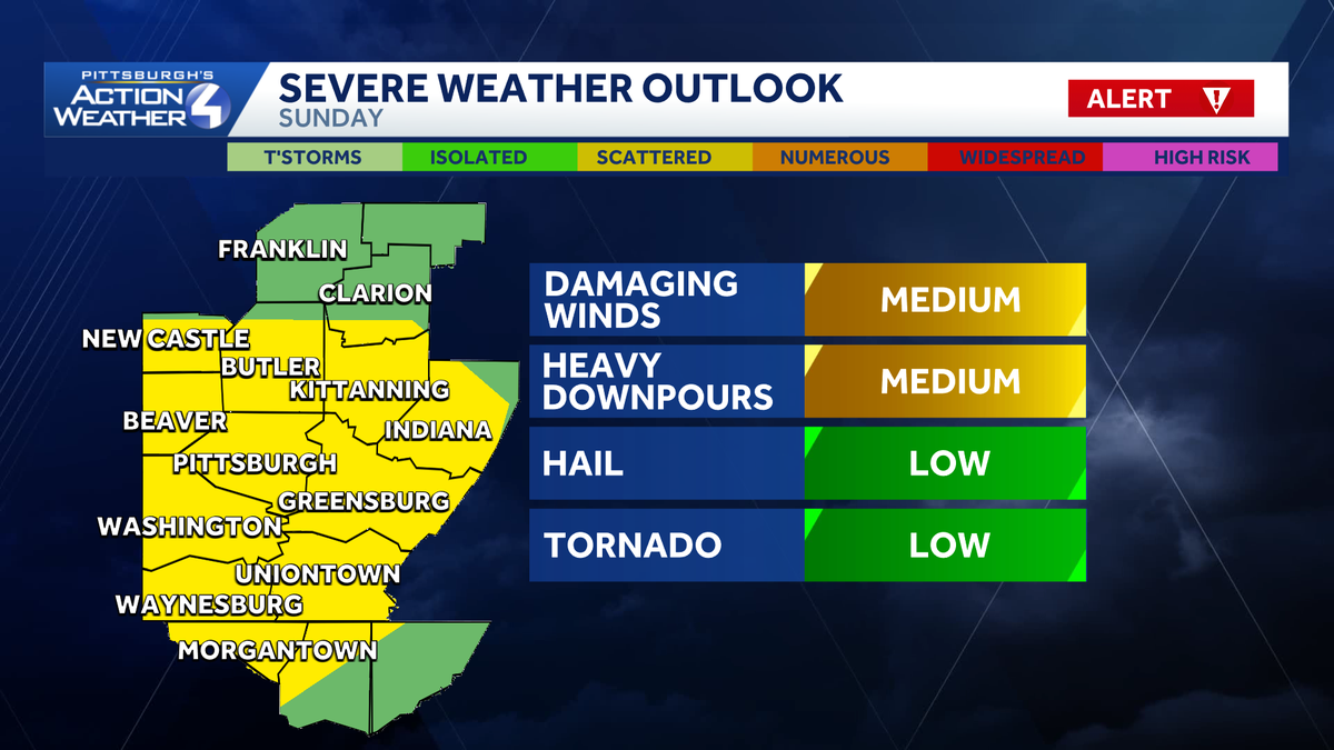
A cold front will approach Western PA in the afternoon and early evening Sunday. As we get to around 5 p.m., thunderstorms could start developing across the region. These storms will have the potential to become strong to severe. All modes of severe weather will be possible, especially if storms can remain discrete before forming into a line, with damaging wind and heavy downpours our primary concerns.

Hearst Owned
All modes of severe weather are possible late Sunday, but damaging winds and heavy downpours are our primary concerns.
Rain and storms will continue into the night with rain heavy at times. Rainfall should come to an end by the morning commute on Monday. Rainfall amounts could potentially reach one inch by the time rain comes to an end.
More Seasonal Next Week
Sunday’s cold front that brings the rain and storms will usher in more seasonal air as we head through next week. High temperatures will be near 50 with rain returning Thursday with another passing cold front.

Hearst Owned
A warm weekend with rain and storms before a more seasonal week next week.
TONIGHT – Partly to Mostly Cloudy. Low: 37°.
SATURDAY: Morning clouds, afternoon sunshine. High: 60°, low: 50°.
SUNDAY – SEVERE WEATHER ALERT DAY: Increasing clouds with late day rain and storms. Strong to severe storms are possible. High: 74°, low: 35°.
MONDAY: Clearing skies and colder. High: 44°, low: 27°.