
IMPACT: Strong to severe storms late Sunday for south-central Pennsylvania
Saturday ends on a mild & pleasant note. Sunday will be warmer with a chance of late evening storms. Some may be strong to severe.
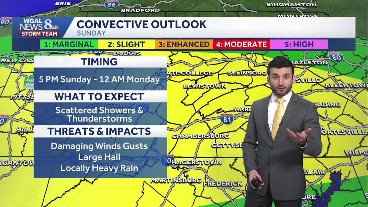
AND LINKS TO THE TRUMP CAMPAIGN. NOW, THE WGAL NEWS EIGHT STORM TEAM FORECAST WITH METEOROLOGIST RYAN ARGENTE. WE HAVE A LEVEL TWO OUT OF FIVE SEVERE WEATHER RISK FOR THE SUSQUEHANNA VALLEY. AS YOU CAN SEE HIGHLIGHTED IN THE YELLOW COLORING HERE. NOW THIS LEVEL TWO OUT OF FIVE. WHAT DOES THIS MEAN. BASICALLY THIS IS THE STORM PREDICTION CENTER’S WAY OF SAYING TO US THAT THERE IS A CHANCE OF SOME SCATTERED THUNDERSTORM ACTIVITY. SOME OF THEM COULD BE STRONG TO SEVERE, BUT IT’S LOOKING IT’S STILL A LOWER CHANCE. AND IN TERMS OF THE INTENSITY, IT VARIES. SO HERE’S SOME OF THE DETAILS THAT WE HAVE HERE IN TERMS OF TOMORROW EVENING FROM 5 P.M. SUNDAY TILL 12 A.M. MONDAY. THAT’S THE TIMING FOR TOMORROW OR FOR TOMORROW EVENING. SO IF YOU HAPPEN TO HAVE ANY PLANS FOR TOMORROW, DON’T WORRY, YOU’LL BE DRY. IN TERMS OF ANY PLANS YOU HAVE FOR THE FIRST HALF OF THE DAY. JUST KEEP IN MIND, DURING THIS TIME PERIOD THAT WE’RE GOING TO START TO SEE THE SCATTERED SHOWER AND THUNDERSTORM ACTIVITY, WITH THE POTENTIAL OF HAVING DAMAGING WIND GUSTS, POTENTIALLY SOME LARGE HAIL, AND ALSO LOCALLY HEAVY RAIN FOR THE AFTERNOON AND THE EVENING OR FOR THE EVENING, I SHOULD SAY. SO. THESE ARE OUR MAIN CONCERNS ARE THE DAMAGING WINDS AND LARGE HAIL. FLOODING IS LOW AND WE CAN’T RULE OUT THE THREAT OF A BRIEF SPIN UP TORNADO, BUT IT’S VERY LOW, AS YOU CAN SEE HERE. AND AGAIN, THAT TIME FRAME IS FROM 5 P.M. SUNDAY TILL 12 A.M. MONDAY. BUT LIVE LOOK OVER YORK NOW. JUST REALLY SEEING SOME MOSTLY CLOUDY CONDITIONS. TEMPERATURES RIGHT AROUND THE LOWER 50S RANGE, BUT WE’LL CONTINUE TO BOTTOM OUT TOWARDS THE TOWARDS THE 40S LATER ON TONIGHT. SO TEMPERATURES EARLIER TODAY HIT A HIGH OF 59 DEGREES. THAT’S A LITTLE MILD FOR THIS TIME OF YEAR. 53 DEGREES IS WHAT WE EXPECT FOR MARCH STANDARDS. AND IN TERMS OF RAINFALL, DIDN’T SEE ANY RAIN RECORDED AT HARRISBURG INTERNATIONAL AIRPORT. SO MOSTLY CLOUDY FOR THE REST OF THE NIGHT TONIGHT. STILL MILD THOUGH 42 TO 46 DEGREES. WE’LL HAVE A SOUTHERLY WIND RIGHT AROUND 5 TO 10MPH. THEN FOR TOMORROW MORNING WE’LL START WITH A MIX OF SOME SUN AND CLOUDS. QUICK WARM UP THOUGH I DID WIDEN OUT THE RANGE HERE FROM 48 TO 58 DEGREES. SO I WOULD SAY THE AVERAGE WOULD BE RIGHT AROUND THE LOWER 50S RANGE FOR TOMORROW MORNING. BUT IT’S GOING TO BE WARMING UP QUICK BECAUSE WE’RE GOING TO HAVE TEMPERATURES GETTING TO THE 70S FOR TOMORROW AFTERNOON. SO VERY WARM. BUT THAT’S GOING TO BE HELPING TO ADD SOME FUEL POTENTIALLY FOR THESE SCATTERED THUNDERSTORMS LATER IN THE EVENING. BUT LIKE I MENTIONED, I’M GOING TO EMPHASIZE ON THIS IS THAT IT’S THE FIRST HALF OF THE DAY. YOU’LL BE FINE. SO IF YOU HAPPEN TO HAVE ANY OUTDOOR ACTIVITIES, YOU’RE GOOD UP UNTIL RIGHT AROUND 5:00 OR 6:00 IN THE EVENING. THAT’S WHEN WE’RE GOING TO START TO WATCH FOR THE CHANCE OF SOME SCATTERED THUNDERSTORMS LATE IN THE DAY. TEMPERATURES INTO THE 50S AT THIS TIME FOR HARRISBURG, YORK, AND CARLISLE, 45 IN LEWISTOWN, 49 IN LEBANON, 48 IN LANCASTER. AT THIS TIME. SEE STORM TEAM LIVE RADAR NETWORK. THE. IN TERMS OF THE. THE. WHAT I WOULD SAY THE SENSITIVITY OF THE REFLECTIVITY HERE FROM THE RADAR. IT SAYS THAT IT’S RAINING, ALTHOUGH IT’S JUST WHAT’S HAPPENING IS JUST GETTING VERY, VERY SMALL PIECES OF MOISTURE PICKING UP. AND IT’S WHAT IT’S DOING. IT’S HIGHLIGHTING IT, MAKING IT SEEM LIKE IT’S RAINING, BUT HAVE NOT GOTTEN ANY RAIN REPORTS AT ALL ACROSS THE AREA. SO REALLY LOOKING AT MOSTLY CLOUDY CONDITIONS UP UNTIL ABOUT SUNDAY MORNING, WHERE WE’LL START TO SEE THAT THE BREAKS OF SOME SUN AND SOME CLOUDS. THEN AS WE GO CLOSER TOWARDS NOON, YOU CAN STILL SEE WE’RE LOOKING AT SOME CLOUDS AND SOME SUNSHINE AND IT’S LOOKING DRY. SO WE’RE GOOD FOR THE FIRST HALF OF THE DAY. BUT THEN HERE COMES RIGHT AROUND 6:00 IN THE EVENING. HERE COMES THIS, THE FIRST LINE OF SOME STORMS THAT’S GOING TO START TO PUSH THROUGH WILL BECOME SCATTERED IN NATURE. YOU CAN SEE RIGHT AROUND 10:00 IN THE EVENING. THAT’S WHEN WE’RE STARTING TO SEE THE BULK OF THOSE STORMS REALLY STARTING TO COME IN LATE IN THE DAY, GETTING INTO SUNDAY NIGHT. AND THEN IN THE WAKE OF THE FRONT THAT’S CAUSING THESE STORMS, LOOKING AT SOME MORE LINGERING MORNING SHOWERS. BUT THEY’RE EARLY MORNING SHOWERS FOR YOUR MONDAY. BY THE TIME YOU GET TO RIGHT AROUND SUNRISE AND INTO THE MORNING COMMUTE, WE’RE REALLY JUST EXPECTING THINGS TO BE DRYING OUT IN THE SUNSHINE WILL START TO BREAK THROUGH AS WE GET INTO MONDAY AFTERNOON, SO MORNING SHOWER RISK AS WE GET INTO MORNING SHOWER CHANCE CHANCE I SHOULD SAY FOR MONDAY WILL BE RIGHT AROUND 50 DEGREES. IT WILL BE FEELI
IMPACT: Strong to severe storms late Sunday for south-central Pennsylvania
Saturday ends on a mild & pleasant note. Sunday will be warmer with a chance of late evening storms. Some may be strong to severe.

Updated: 11:45 PM EDT Mar 21, 2026
Cloud cover will continue increasing heading through tonight. Lows will drop to the lower 40s range with winds remaining light.Sunday will feature morning sunshine, then increasing clouds and warmer highs in the lower to mid 70s. Scattered showers and thunderstorms are expected along a cold front during the evening on Sunday. The Storm Prediction Center has highlighted the Susquehanna Valley as at risk for a few strong thunderstorms. Main threats include damaging winds gusts, large hail, and locally heavy rainfall will be the main concern. There is also a very low chance for a brief, spin-up tornado. Due to the threat of severe storms, the News 8 Storm Team has made Sunday evening an Impact period.However, the strength of the storms will depend on the amount of instability (thunderstorm fuel) available at the time of development. The lack of instability may prevent storms from reaching their full potential and remain under severe limits. In this case, we will see just some showers and a few rumbles of thunder.In the wake of the cold front that passes through Sunday night, expect lingering rain showers into early Monday before tapering by sunrise. Estimated rainfall from Sunday night through Monday morning could be up to an inch from the heaviest storms. Monday afternoon will feature clearing skies and highs in the upper 40s to lower 50s along with a stiff northwest breeze. Winds could get between 10-20 mph, with gusts up to 30 mph!Highs will reach the upper 40s to lower 50s on Tuesday, and lower to mid 50s are likely. Both days are forecast to be dry with mostly sunny to partly sunny skies.Temperatures climb to the upper 50s on Thursday, then a chance of showers returns late Thursday into Friday.Temperatures will cool to the upper 40s to near 50 degrees for the following weekend.Have a great rest of your Saturday night!~ Ryan
Cloud cover will continue increasing heading through tonight. Lows will drop to the lower 40s range with winds remaining light.
Sunday will feature morning sunshine, then increasing clouds and warmer highs in the lower to mid 70s. Scattered showers and thunderstorms are expected along a cold front during the evening on Sunday. The Storm Prediction Center has highlighted the Susquehanna Valley as at risk for a few strong thunderstorms. Main threats include damaging winds gusts, large hail, and locally heavy rainfall will be the main concern. There is also a very low chance for a brief, spin-up tornado. Due to the threat of severe storms, the News 8 Storm Team has made Sunday evening an Impact period.
However, the strength of the storms will depend on the amount of instability (thunderstorm fuel) available at the time of development. The lack of instability may prevent storms from reaching their full potential and remain under severe limits. In this case, we will see just some showers and a few rumbles of thunder.
In the wake of the cold front that passes through Sunday night, expect lingering rain showers into early Monday before tapering by sunrise. Estimated rainfall from Sunday night through Monday morning could be up to an inch from the heaviest storms. Monday afternoon will feature clearing skies and highs in the upper 40s to lower 50s along with a stiff northwest breeze. Winds could get between 10-20 mph, with gusts up to 30 mph!
Highs will reach the upper 40s to lower 50s on Tuesday, and lower to mid 50s are likely. Both days are forecast to be dry with mostly sunny to partly sunny skies.
Temperatures climb to the upper 50s on Thursday, then a chance of showers returns late Thursday into Friday.
Temperatures will cool to the upper 40s to near 50 degrees for the following weekend.
Have a great rest of your Saturday night!
~ Ryan