
BY COMPANY PERSONNEL AND THE NATIONAL GUARD. METEOROLOGIST RYAN ARGENTE JOINS ME NOW WITH HOW THESE STORMS RIGHT HERE IN THE SUSQUEHANNA VALLEY ARE SET TO IMPACT US. RYAN, WHAT SHOULD WE KNOW? YEAH. SO, TAYLOR, WE ARE WE WE HAVE MADE THIS EVENING AN ALERT EVENING FOR THE THREAT OF THE STRONG, SEVERE STORMS THAT YOU CAN ALREADY SEE ALREADY STARTING TO MOVE INTO THE AREA WHERE WE’RE STARTING TO SEE SOME SEVERE THUNDERSTORM WARNINGS BEGINNING TO MOVE THROUGH NOW, JUST A SECOND AGO, LOOKS LIKE THE NATIONAL WEATHER SERVICE HAS ALLOWED THE SEVERE THUNDERSTORM TO EXPIRE THAT WAS STARTING TO MOVE THROUGH FAR NORTHEASTERN PORTIONS OF MIFFLIN COUNTY, BUT YOU CAN STILL SEE A LOT OF LIGHTNING BOLTS COMING OUT OF THE CELL AND SOME HEAVY, HEAVY RAIN. SO. AND IT’S NOT OVER YET. WE ARE STILL LOOKING AT A LOOK AT THE LOOK AT THE LINE OF SOME STORMS THAT YOU CAN SEE HERE ALL THROUGH JOHNSTOWN, STARTING TO MOVE INTO PORTIONS OF WEST CENTRAL PENNSYLVANIA. THAT IS LOOKING LIKE IT’S GOING TO BE ON TRACK TO ENTERING THE VALLEY HERE IN THE NEXT HOUR OR TWO, SOMETHING THAT WE’RE GOING TO CONTINUE TO WATCH AS WE GET INTO THE AS WE GET INTO THE REST OF THIS EVENING, SEVERE THUNDERSTORM WATCH, IN EFFECT UNTIL 10:00 TONIGHT FOR MIFFLIN AND JUNIATA. PERRY, DAUPHIN, CUMBERLAND AND FRANKLIN COUNTIES. AGAIN, THAT’S UNTIL 10:00 THIS EVENING. EARLIER THIS AFTERNOON, THE STORM PREDICTION CENTER HAS UPGRADED PARTS OF THE SUSQUEHANNA VALLEY TO A LEVEL THREE OUT OF FIVE SEVERE WEATHER RISKS. SO THIS IS AN ENHANCED RISK FOR MAINLY AREAS THAT ARE WEST OF THE RIVER. NOW YOU CAN SEE DAUPHIN AND PORTIONS OF LEBANON COUNTY STILL IN PORTIONS OF THAT ENHANCED RISK. AND ALSO OUR FAR SOUTHEASTERN COMMUNITIES TOWARDS YORK AND LANCASTER COUNTIES. STILL IN THAT LEVEL, TWO OUT OF FIVE SEVERE WEATHER RISK. BUT HERE’S THE DETAILS FOR THIS EVENING. FROM NOW UNTIL 12 A.M. MONDAY. SO MIDNIGHT TONIGHT. EXPECT THESE SCATTERED THUNDERSTORMS. SOME OF THESE COULD BE STRONG TO SEVERE. EXPECT THESE TO PERSIST THROUGH THE NEXT SEVERAL HOURS. THEN WE’RE GOING TO BE SEEING SOME RAIN OVERNIGHT AND WILL BE ENDING EARLY MONDAY. SOME OF THAT RAIN COULD BE HEAVY AT TIMES. POTENTIAL HAZARDS FOR THE REST OF THIS EVENING COULD BE SEEING SOME DAMAGING WINDS, LARGE HAIL, HEAVY RAIN AND THERE’S A VERY LOW TORNADO THREAT FOR THIS EVENING. IT’S A VERY LOW THREAT. I WANT TO EMPHASIZE THAT, BUT WE COULD SEE SOME PONDING ON THE ROADS AS WE HEAD INTO THE REST OF THIS EVENING. SO HERE’S THE FORECAST FOR THE REST OF THE FOR THE REST OF THE DAY. TEMPERATURES INTO THE 60S, 66 TO 72 DEGREES, FAIRLY MILD OUT THERE FOR THIS. FOR THIS TIME OF THE YEAR, WE’LL HAVE A SOUTHWESTERLY 10 TO 15 MILE PER HOUR BREEZE. AS THESE STORMS BEGIN TO MOVE THROUGH. THEN FOR TONIGHT, WE’LL SEE THAT RAIN COULD BE HEAVY AT TIMES, BUT WE COULD BE SEEING SOME PATCHY FOG DEVELOP AS THAT RAIN FRESHLY FALLS ONTO THE SURFACES. STILL MILD THOUGH. OVERNIGHT 42 TO 46 DEGREES, THEN 48 TO 52 FOR TOMORROW. WE’LL HAVE THOSE MORNING SHOWERS ENDING. BECOMING PARTLY SUNNY. NOW IN THE LATEST DATA, I DID SEE THAT THERE WAS A LITTLE BIT OF AN ISOLATED SHOWER CHANCE, SO I DID. I DID THROW THAT THIRD LINE IN THERE IN TERMS OF THAT SHOWER CHANCE LATER ON TOMORROW EVENING, BUT IT’S A VERY IT’S AN ISOLATED THREAT. MOST OF THE AREA LOOKS LIKE IT WILL BE REMAINING DRY. SO LOOK AT THIS. TEMPERATURES INTO THE 70S. NOW. THEY’LL SOON GO DOWN TOWARDS THE LOWER 70S LATER ON THIS EVENING. BUT HERE’S STORM TEAM LIVE RADAR NETWORK ONCE MORE JUST SHOWING YOU WHERE WHERE WE’RE AT IN TERMS OF SOME OF THESE STORMS BEGINNING TO MOVE THROUGH. A LOT OF LIGHTNING COMING IN ALONG THIS LINE. WE’RE GOING TO CONTINUE TO MONITOR THIS OVER THE NEXT SEVERAL HOURS, BUT THIS IS GOING TO PERSIST AS WE GO THROUGH THE REST OF THIS EVENING. YOU CAN SEE TOWARDS 9:00 SEEING SOME OF THAT ISOLATED STORM ACTIVITY STILL SCATTERED. AND THEN ONCE WE MOVE ON CLOSER TO 10:00, 11:00, 12 MIDNIGHT, THAT’S WHEN THE THREAT BEGINS TO WANE. BUT LOOK AT THIS IN THE WAKE OF THAT FRONT OR AS THAT FRONT CONTINUES TO PUSH THROUGH, WE’RE LOOKING AT SOME WE’RE LOOKING AT RAIN AND WE COULD SEE SOME HEAVY POCKETS OF SOME SHOWERS OVERNIGHT TONIGHT. BUT THEN AS WE GET INTO OUR MONDAY MORNING, THAT RAIN BEGINS TO MOVE OUT AND WE’LL SEE SOME JUST SOME SCATTERED SHOWER CHANCES ONCE WE GET INTO THE MIDDLE OF THE MORNING MONDAY. SO IN TERMS OF WHAT TO EXPECT THOUGH, AS WE GET INTO THE REST OF OUR MONDAY AND TUESDAY, WE’LL SEE SOME CLEARING AS HIGH PRESSURE BEGINS TO BUILD IN. THAT’S GOING TO SET US UP WITH SOME MOSTLY SUNNY CONDITIONS. WE GET INTO OUR TUESDAY AND ALSO ALLOW FOR SOME SEASONABLE CONDITIONS FOR THE MIDDLE OF THE WORKWEEK. AS YOU CAN SEE HERE, TEMPERATURES RIGHT INTO THE LOWER 50S. AS WE GET INTO OUR MONDAY AND TUESDAY, MORE SEASONABLE FOR WEDNESDAY, WE BUMP UP TO 64
ALERT: Strong to severe storms developing in south-central Pennsylvania
Storms will move through parts of the Valley tonight and weaken by the time we reach midnight. Expect lingering morning showers for the start of our Monday. Clearing skies are expected Monday afternoon.

Updated: 6:23 PM EDT Mar 22, 2026
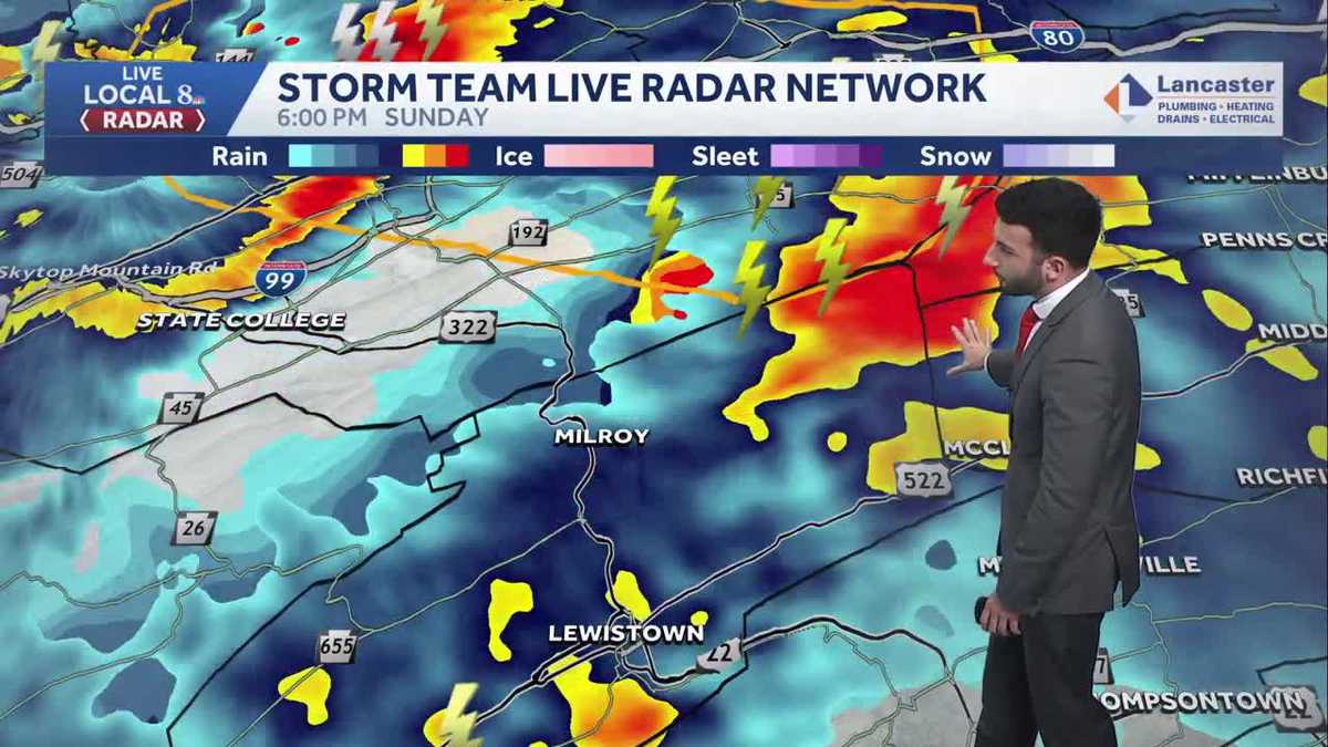
A Severe Thunderstorm Watch has been issued for Mifflin, Juniata, Perry, Franklin, Cumberland, & Dauphin counties until 10 pm. ALERT EVENING: STRONG TO SEVERE STORMS POSSIBLEAfter mostly sunny skies and highs topping out in the upper 70s/low 80s in most areas, clouds have increased and storms are beginning to erupt across the Valley, due to a cold front dropping into Pennsylvania. Mainly after 6 pm, thunderstorms will develop in counties north of the PA Turnpike. Some storms may be strong to severe, with damaging wind gusts and large hail as the main threats. The threat for a weak, brief, spin-up tornado is very low.Storms will move south of the PA Turnpike after 9 p.m. and the threat for scattered strong storms and heavy rain will continue until midnight.After midnight, expect areas of moderate to heavy rain, as the cold front slowly moves south. Rain totals from the entire event will range from 0.25″ to near 1″. Watch for ponding on roads, but flash flooding is not expected.BREEZY MONDAY:The last few showers will end in southeastern counties around sunrise Monday. Sustained winds will increase to 15-25 mph from the northwest, with gusts to 35 mph. Temperatures will fall to the low-to-mid 40s Monday morning, then rebound to near 50 degrees Monday afternoon. What a change from Sunday!Look for plentiful sunshine Tuesday with highs near 50 degrees, and partly sunny conditions Wednesday, along with seasonable highs in the mid-50s.Thursday will be warmer, near 60 degrees, with a chance of showers late in the day, as a cold front approaches. Showers will linger into Friday morning, then expect breezy and cooler conditions at the end of the week. Friday’s highs will fall to the low 50s, and upper 40s are expected Saturday.Sunday will feature highs in the mid-50s, then temperatures will climb to near 60 degrees early next week. The next chance of showers arrives on Tuesday.Stay safe, stay weather aware this evening, and have a good rest of your Sunday!~ Ryan
A Severe Thunderstorm Watch has been issued for Mifflin, Juniata, Perry, Franklin, Cumberland, & Dauphin counties until 10 pm.
ALERT EVENING: STRONG TO SEVERE STORMS POSSIBLE
After mostly sunny skies and highs topping out in the upper 70s/low 80s in most areas, clouds have increased and storms are beginning to erupt across the Valley, due to a cold front dropping into Pennsylvania. Mainly after 6 pm, thunderstorms will develop in counties north of the PA Turnpike. Some storms may be strong to severe, with damaging wind gusts and large hail as the main threats. The threat for a weak, brief, spin-up tornado is very low.
Storms will move south of the PA Turnpike after 9 p.m. and the threat for scattered strong storms and heavy rain will continue until midnight.
After midnight, expect areas of moderate to heavy rain, as the cold front slowly moves south. Rain totals from the entire event will range from 0.25″ to near 1″. Watch for ponding on roads, but flash flooding is not expected.
BREEZY MONDAY:
The last few showers will end in southeastern counties around sunrise Monday. Sustained winds will increase to 15-25 mph from the northwest, with gusts to 35 mph. Temperatures will fall to the low-to-mid 40s Monday morning, then rebound to near 50 degrees Monday afternoon. What a change from Sunday!
Look for plentiful sunshine Tuesday with highs near 50 degrees, and partly sunny conditions Wednesday, along with seasonable highs in the mid-50s.
Thursday will be warmer, near 60 degrees, with a chance of showers late in the day, as a cold front approaches. Showers will linger into Friday morning, then expect breezy and cooler conditions at the end of the week. Friday’s highs will fall to the low 50s, and upper 40s are expected Saturday.
Sunday will feature highs in the mid-50s, then temperatures will climb to near 60 degrees early next week. The next chance of showers arrives on Tuesday.
Stay safe, stay weather aware this evening, and have a good rest of your Sunday!
~ Ryan