
ALERT: Storms continue through midnight; lingering showers into early Monday across south-central Pennsylvania
Storms will move through parts of the Valley tonight and weaken by the time we reach midnight. Expect lingering morning showers for the start of our Monday. Clearing skies are expected Monday afternoon.
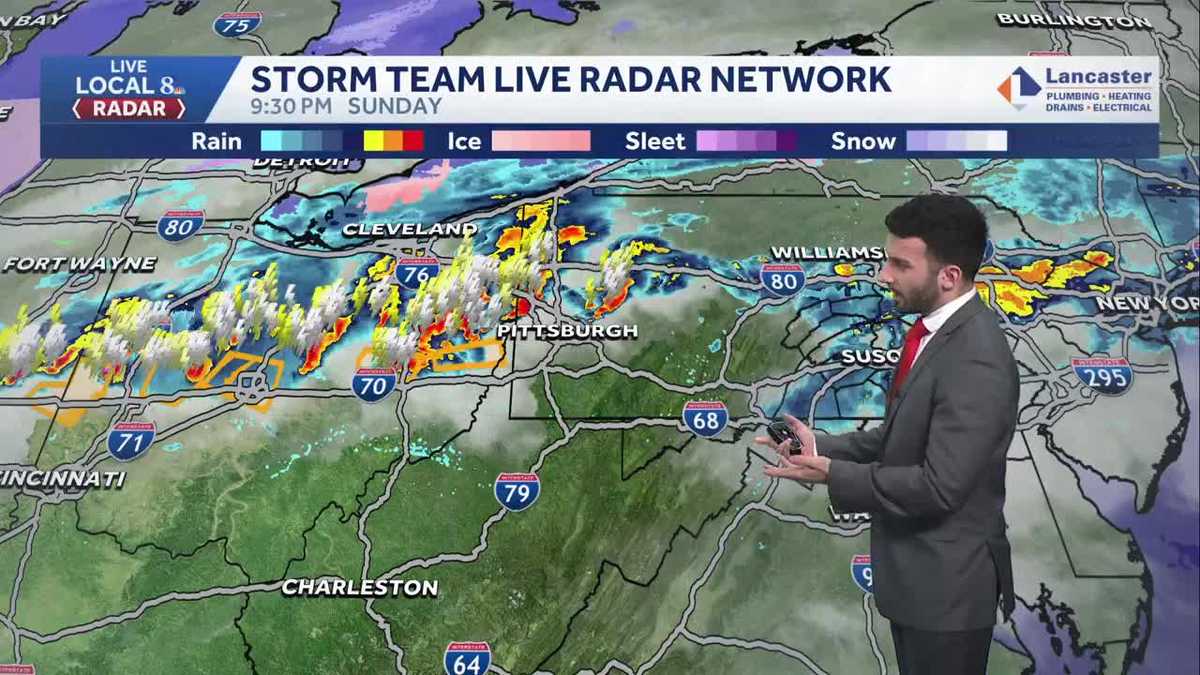
BY COMPANY PERSONNEL AND THE NATIONAL GUARD. JOINS ME NOW WITH HOW STORMS HERE IN THE SUSQUEHANNA VALLEY ARE SET TO IMPACT US, AROUND WHICH WE KNOW. WHAT ARE YOU TRACKING RIGHT NOW? SO TRACKING THAT CHANCE FOR SOME SEVERE WEATHER, EVEN GETTING INTO THE NEXT COUPLE OF HOURS. MCKENNA. WE’RE STILL TRACKING OUR STORM TEAM, LIVE RADAR NETWORK. SOME OF THESE WHAT THEY LOOK LIKE ARE BEGINNING TO REALLY JUST STARTING TO WEAKEN THESE THESE STRONGER STORMS. BUT YOU SEE, THERE’S STILL A LITTLE BIT OF A DOWNPOUR THAT’S STARTING TO STARTING TO FILL IN. YOU CAN SEE A BIT OF A DOWNPOUR JUST OUTSIDE OF HUMMELSTOWN MOVING ITS WAY EASTWARD TOWARDS CORNWALL IN SOUTHERN LEBANON COUNTY, ALSO ABOUT JUST A SIDE SWIPE, NORTHERN LANCASTER COUNTY HERE IN TOWARDS YORK COUNTY, ADAMS AND YORK COUNTY, A LITTLE BIT OF A HEAVIER DOWNPOUR STARTING TO COME IN OR A MODERATE SHOWER, I SHOULD SAY. RATHER. MOVING IN ON TO WELLSVILLE. ALSO EAST BERLIN, JUST STARTING TO MOVE OUT OF YORK SPRINGS, SOMETHING WE’RE WATCHING THOUGH THE NATIONAL WEATHER SERVICE HAS EXTENDED THE SEVERE THUNDERSTORM WATCH UNTIL 12 A.M., AND I CAN SUSPECT. WHY IS BECAUSE WE’RE SEEING THIS LINE OF THUNDERSTORMS THAT IS STILL OFF TOWARDS THE OHIO RIVER VALLEY. STILL SEE SOME OF THESE SEVERE THUNDERSTORM BOXES, BUT THAT’S OVER TOWARDS OHIO AND LOOKS LIKE IT MAY COME THIS WAY TOWARDS THE CLOSER TO THE SUSQUEHANNA VALLEY. STILL GOING TO CONTINUE TO MONITOR AS WE HEAD INTO THE INTO THE OVERNIGHT PERIOD. OVER THE NEXT FEW HOURS. SO SEVERE THUNDERSTORM WATCH REMAINS IN EFFECT UNTIL 12 A.M. THAT’S FOR MIFFLIN, JUNIATA, PERRY, CUMBERLAND, DAUPHIN AND FRANKLIN COUNTIES AGAIN. ONCE AGAIN, 12 A.M. IS WHEN WE’RE EXPECTING EXPECTING THESE IMPACTS TO BE HAPPENING. SO DAMAGING WINDS AND LARGE HAIL STILL REMAINS TO BE THE MAIN THREATS, ALTHOUGH THE FLOODING STILL LOW TORNADOES, IT’S A VERY LOW CHANCE AT THIS POINT IN THE NIGHT. I DO SUSPECT THAT THE TORNADO CHANCE WILL BE VERY SLIM TO NO CHANCE. AS WE GET AS WE GET INTO AS WE GET INTO TONIGHT. SO TODAY THOUGH, LET’S TALK ABOUT SOME OF THE STATS EARLIER TODAY. A BIT OF A SUNNY DAY. VERY NICE DAY TODAY. 80 DEGREES WAS THE HIGH AT HARRISBURG INTERNATIONAL AIRPORT. BUT NOTICE THIS 80 DEGREES. THAT WAS THE RECORD BACK IN 1938. WE TIED THAT 1938 RECORD AS OF JUST AS OF TODAY. BUT FROM THE THE AFTERNOON AND EVENING CLIMATOLOGICAL REPORT, NO RAINFALL WAS, WAS, WAS ACCUMULATED, WAS REPORTED. BUT WE’LL CONTINUE THIS THIS ALERT PERIOD UNTIL 12 A.M. UNTIL THE TIME THAT THE SEVERE THUNDERSTORM WATCH ENDS. SO STORMS WILL BEGIN TO END OVERNIGHT. WE’LL STILL SEE SOME RAIN. THEY’LL STILL BE HEAVY AT TIMES. WE’LL START TO SEE SOME PATCHY FOG DEVELOP. IT WILL STILL REMAIN MILD TOO. WILL BE INTO THE LOWER TO MID 40S THEN FOR TOMORROW. STILL SEEING THOSE LINGERING SHOWERS, BUT I DO BELIEVE THEY’LL BE ENDING BY 8:00 IN THE MORNING. WE’LL START TO SEE SOME DECREASING CLOUDS AND WE’LL SEE SOME PARTLY SUNNY CONDITIONS FOR TOMORROW AFTERNOON. IT WILL BE A LITTLE BIT WINDY THOUGH. ISOLATED SHOWER CHANCE LATER IN THE DAY FOR THE EVENING. COULD SEE GUSTS UPWARDS OF 35MPH FOR THE AFTERNOON. TEMPERATURES INTO THE 60S TOWARDS LANCASTER, YORK, HARRISBURG, CARLISLE ALL INTO THE LOWER 60S, AND SOME OF US TOWARDS CHAMBERSBURG AND GETTYSBURG INTO THE MID TO UPPER 60S. BUT NOTICE THE STRENGTH OF THIS COLD FRONT THAT’S GOING TO START TO COME THROUGH. YOU CAN SEE THAT DELINEATION HERE CROSSING THROUGH THE OHIO RIVER VALLEY. ALSO GETTING INTO KENTUCKY, WHERE YOU CAN SEE THAT DIFFERENCE IN TEMPERATURES OF ACROSS ACROSS THE STATE. SO STILL LOOKING AT SOME OF THESE SHOWERS BEGINNING TO MOVE THROUGH. AND WE’RE STILL WATCHING THIS LINE OF SOME SEVERE STORMS THAT WILL CONTINUE TO MAKE ITS WAY EASTWARD TOWARDS THE SUSQUEHANNA VALLEY. I DO BELIEVE THAT THE SEVERE WEATHER ACTIVITY ENDS RIGHT AROUND 1:00 OR 2 A.M., WHERE ALL THESE ORANGES AND YELLOWS THAT YOU SEE, I THINK ARE GOING TO BE MORE MODERATE SHOWERS. SO AGAIN, HEAVY RAIN AT TIMES IS POSSIBLE. NOW IN THE WAKE OF THE COLD FRONT THAT PUSHES THROUGH, WE WILL START TO SEE SOME HIGH PRESSURE BUILDING IN. AND THAT’S GOING TO HELP CLEAR OUR SKIES AS WE GET INTO THE EVENING. TOMORROW, ALSO INTO OUR TUESDAY, YOU CAN SEE THAT BIG, BIG BLUE H STARTING TO SETTLE IN OVER THE AREA. AND THAT’S GOING TO HELP TO HELP TO KEEP US SEASONABLE AS WE GET INTO THE MIDDLE OF THE WORKWEEK. SO WE’RE INTO THE 50S FOR TUESDAY AND WEDNESDAY
ALERT: Storms continue through midnight; lingering showers into early Monday across south-central Pennsylvania
Storms will move through parts of the Valley tonight and weaken by the time we reach midnight. Expect lingering morning showers for the start of our Monday. Clearing skies are expected Monday afternoon.

Updated: 10:51 PM EDT Mar 22, 2026
A Severe Thunderstorm Watch has been extended for Mifflin, Juniata, Perry, Franklin, Cumberland, & Dauphin counties until 12 am Monday.ALERT FOR STRONG TO SEVERE STORMSThunderstorms have continued through the late evening into early tonight & the chance for storms will persist for the next couple to few hours. Some storms may be strong to severe, with damaging wind gusts and large hail as the main threats. After midnight, expect storms to weaken and areas of moderate to heavy rain to continue moving through with the passage of a cold front slowly moving south. Rain totals from the entire event will range from 0.25″ to near 1″. Watch for ponding on roads, but flash flooding is not expected.BREEZY MONDAY:The last few showers will end in southeastern counties around sunrise Monday. Sustained winds will increase to 15-25 mph from the northwest, with gusts to 35 mph. Temperatures will fall to the low-to-mid 40s Monday morning, then rebound to near 50 degrees Monday afternoon. What a change from Sunday!Look for plentiful sunshine Tuesday with highs near 50 degrees, and partly sunny conditions Wednesday, along with seasonable highs in the mid-50s.Thursday will be warmer, near 60 degrees, with a chance of showers late in the day, as a cold front approaches. Showers will linger into Friday morning, then expect breezy and cooler conditions at the end of the week. Friday’s highs will fall to the low 50s, and upper 40s are expected Saturday.Sunday will feature highs in the mid-50s, then temperatures will climb to near 60 degrees early next week. The next chance of showers arrives on Tuesday.Stay safe, stay weather aware tonight, and have a good rest of your night!~ Ryan
A Severe Thunderstorm Watch has been extended for Mifflin, Juniata, Perry, Franklin, Cumberland, & Dauphin counties until 12 am Monday.
ALERT FOR STRONG TO SEVERE STORMS
Thunderstorms have continued through the late evening into early tonight & the chance for storms will persist for the next couple to few hours. Some storms may be strong to severe, with damaging wind gusts and large hail as the main threats.
After midnight, expect storms to weaken and areas of moderate to heavy rain to continue moving through with the passage of a cold front slowly moving south. Rain totals from the entire event will range from 0.25″ to near 1″. Watch for ponding on roads, but flash flooding is not expected.
BREEZY MONDAY:
The last few showers will end in southeastern counties around sunrise Monday. Sustained winds will increase to 15-25 mph from the northwest, with gusts to 35 mph. Temperatures will fall to the low-to-mid 40s Monday morning, then rebound to near 50 degrees Monday afternoon. What a change from Sunday!
Look for plentiful sunshine Tuesday with highs near 50 degrees, and partly sunny conditions Wednesday, along with seasonable highs in the mid-50s.
Thursday will be warmer, near 60 degrees, with a chance of showers late in the day, as a cold front approaches. Showers will linger into Friday morning, then expect breezy and cooler conditions at the end of the week. Friday’s highs will fall to the low 50s, and upper 40s are expected Saturday.
Sunday will feature highs in the mid-50s, then temperatures will climb to near 60 degrees early next week. The next chance of showers arrives on Tuesday.
Stay safe, stay weather aware tonight, and have a good rest of your night!
~ Ryan