
Today looks terrific with plenty of sunshine. Temperatures not as much with highs shy of 50 degrees. A warming trend continue through Thursday ahead of our next rain chance.Warming up through mid-weekThere is a definite chill this morning with lows in the 20s. Readings will spike around 50° with plenty of sunshine by the afternoon. Temperatures continue to warm through Thursday. High will peak around 60 degrees tomorrow; 70° for Thursday.Next rain chance late ThursdayThursday will begin as another nice spring day with highs near 70°. We are watching another cold front that will sweep through western Pennsylvania. Rain will arrive late-day or wait until after dark. The wettest time frame will be overnight into Friday morning with periods of rain and an isolated thunder chance. We could see up to an inch of rain across Western PA. Friday morning is now an Impact Day.Another cool downTemperatures will be knocked back, again, into the 40s to wrap up the work and school week. At this point, the weekend will be dry and seasonably cool. Highs still be in the 40s on Saturday before skipping to mid 50s on Sunday. A warming trend will take shape heading into April in the long-term forecast.TODAY: Still cool with mostly sunny skies. High: 48°.TONIGHT: Increasing clouds, low: 35°.WEDNESDAY: Milder with intervals of sun and clouds. High: 60°, low: 49°.THURSDAY: Cloudy and warmer with rain arriving late-day. High: 70°, low: 40°.FRIDAY – Impact Day: Morning rain, mostly cloudy afternoon. High: 47°, low: 24°.
PITTSBURGH —
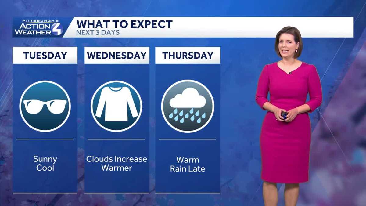
Today looks terrific with plenty of sunshine. Temperatures not as much with highs shy of 50 degrees. A warming trend continue through Thursday ahead of our next rain chance.
Warming up through mid-week
There is a definite chill this morning with lows in the 20s. Readings will spike around 50° with plenty of sunshine by the afternoon. Temperatures continue to warm through Thursday. High will peak around 60 degrees tomorrow; 70° for Thursday.

Hearst OwnedHearst
A cold start will turn into a seasonably cool afternoon around the Pittsburgh area. At least there will be plenty of sunshine.
Next rain chance late Thursday
Thursday will begin as another nice spring day with highs near 70°. We are watching another cold front that will sweep through western Pennsylvania. Rain will arrive late-day or wait until after dark. The wettest time frame will be overnight into Friday morning with periods of rain and an isolated thunder chance. We could see up to an inch of rain across Western PA. Friday morning is now an Impact Day.

Hearst OwnedHearst
Rain arrives late Thursday and lingers into Friday morning. A new Impact Day at least through the first half of Friday for flooding concerns south of Pittsburgh.
Another cool down
Temperatures will be knocked back, again, into the 40s to wrap up the work and school week. At this point, the weekend will be dry and seasonably cool. Highs still be in the 40s on Saturday before skipping to mid 50s on Sunday. A warming trend will take shape heading into April in the long-term forecast.

Hearst OwnedHearst
Conditions dry out and cool down, again, in time for the weekend.
TODAY: Still cool with mostly sunny skies. High: 48°.
TONIGHT: Increasing clouds, low: 35°.
WEDNESDAY: Milder with intervals of sun and clouds. High: 60°, low: 49°.
THURSDAY: Cloudy and warmer with rain arriving late-day. High: 70°, low: 40°.
FRIDAY – Impact Day: Morning rain, mostly cloudy afternoon. High: 47°, low: 24°.