
Pittsburgh: Warmer before rain and two Impact Days
Rain returns late Thursday with isolated flooding concerns through Friday morning.
WE’LL BE FOLLOWING THAT CLOSELY. IT’S ANOTHER DAY THAT YOU WON’T NEED THE UMBRELLAS, BUT THEY WILL COME IN HANDY, ESPECIALLY LATE TOMORROW INTO THE START OF FRIDAY. NOW BACK TO BACK IMPACT DAYS. AS WE’RE WRAPPING UP THIS WORK AND SCHOOL WEEK, CONCERNS THAT WE COULD SEE SOME LOCALIZED FLOODING BY THE TIME WE HIT FRIDAY MORNING, BUT FAR FROM IT. RIGHT NOW WE ARE STARTING TO SEE A FEW CLOUDS NUDGING ACROSS OUR SKIES, BUT STILL BEAUTIFUL SHOT OF OUR CITY AS WE GET YOUR WEDNESDAY STARTED, TAKE A LIVE LOOK WITH ACTION CAM. LET’S BREAK DOWN THE NEXT 12 HOURS. NOT NEARLY AS CHILLY AS IT WAS YESTERDAY. OF COURSE, SOME OF US. WE’RE STARTING OFF CLOSE TO 20 THIS MORNING, STILL FROSTY. WE’RE IN THE MID 30S, WORKING OUR WAY TOWARDS THE LUNCH HOUR. TEMPERATURES ALREADY IN THE 50S. ONE THING YOU WILL NOTICE THAT WE ENJOYED YESTERDAY. WE’RE NOT GOING TO SEE AS MUCH SUNSHINE AS WE GO THROUGH THE DAY. BUT TEMPERATURES WILL BE WARMER AS WE START TO BUILD THOSE NUMBERS BACK INTO THE LOWER 60S. SO YOUR 4-DAY PLUS 4 MORE FORECAST CHILLY THIS MORNING, PLEASANT BY THE AFTERNOON. BUT AGAIN, WE HAVE MORE CLOUDS. 62 OUR HIGH STILL WARMER DURING THE DAY. THURSDAY WILL SPIKE AT ABOUT 70. THE IMPACT PART OF YOUR DAY COMES IN SHORTLY AFTER SUNSET AS WE’LL SEE AREA WIDE RAIN. SOME EMBEDDED DOWNPOURS, POSSIBLY EVEN AN ISOLATED RUMBLE OF THUNDER. THAT HEAVY RAIN DOES EXTEND INTO FRIDAY MORNING AGAIN. OUR SECOND IMPACT DAY IN A ROW. YOU WILL NOTICE THOSE TEMPERATURES ARE TUMBLING AT LEAST THROUGH SATURDAY FOR ANOTHER WARMING TREND TAKES SHAPE, AND THAT LOOKS TO CONTINUE INTO THE FIRST DAY OF APRIL. COME THIS TIME NEXT WEEK. LET’S LOOK AHEAD TO THAT IMPACT DAY TOMORROW. WAKING UP, WE WILL SEE MOSTLY CLOUDY SKIES LATE MORNING TOWARDS THE LUNCH HOUR, SOME ISOLATED SHOWERS COULD START TO SHOW UP. THEY SHOULD BE LIGHT AND BRIEF IN NATURE AGAIN. THE MAIN FOCUS OF OUR IMPACT DAY COMING IN AFTER THE EVENING COMMUTE TOWARDS ABOUT SUNSET, WE’LL SEE AN AREA WIDE THREAT FOR RAIN MIXED IN, SOME DOWNPOURS, POSSIBLY EVEN SOME RUMBLES OF THUNDER FROM STRONGER STORMS THAT COULD EXTEND THROUGH THE OVERNIGHT HOURS AS THEY COME OUT OF OHIO. YOU CAN ALREADY SEE SOME OF THOSE DEEPER SHADES OF ORANGE AND RED SHOWING UP AROUND NEW CASTLE BEAVER AROUND 11:00 TOMORROW NIGHT. THAT WILL CONTINUE THROUGH THE OVERNIGHT HOURS AS THE SYSTEM CONTINUES TO DIVE SOUTH THROUGH WESTERN PENNSYLVANIA. IF YOU’RE AN EARLY RISER, EARLY COMMUTER ON FRIDAY, STILL EXPECTING THAT AREA WIDE RAIN TO IMPACT YOU AROUND 5:00 IN THE MORNING. AGAIN, SOME OF THAT HEAVY RAIN STILL SETTLING IN, ESPECIALLY FROM THE CITY OF PITTSBURGH ON SOUTH. BUT BY THE TIME THE KIDDOS ARE OUT THE DOOR, AS WE LOOK TOWARDS ABOUT SEVEN, EIGHT, EVEN 9:00 IN THE MORNING, MOST OF THAT RAIN WILL BE THROUGH AND IT WILL BE A QUIETER, ALTHOUGH BE CHILLY SECOND HALF OF THE DAY ON FRIDAY. IN TERMS OF OUR STORM THREATS, LEADING THE WAY WILL BE THE ISOLATED FLOODING RISK AS WE COULD PICK UP UP TO AN INCH OF RAIN IN A NUMBER OF SPOTS. BUT ALSO SOME OF THOSE STRONGER STORMS WILL PACK A PUNCH WITH SOME GUSTY WINDS, EVEN SOME ISOLATED LARGE HAIL. AGAIN, THAT WILL BE ALL THURSDAY NIGHT INTO FRIDAY. NOT THE BEST TIME FOR STORMS TO REALLY PACK A PUNCH, BUT CERTAINLY SOMETHING WE’LL BE MONITORING AGAIN. DELIGHTFUL DURING THE DAY. OUTSIDE THOSE ISOLATED SHOWERS EARLY ON THURSDAY, WE HAVE A HIGH OF 70 THAT IMPACT DAY EXTENDING INTO FRIDAY MORNING. TEMPERATURES DROP. WE’RE ONLY IN THE 40S TO AT LEAST KICK OFF THE WEEKEND, BUT WE’LL TACK ON ABOUT TEN DEGREES BY THE TIME WE HIT SUNDAY. GOOD NEWS ABOUT THE WEEKEND. IF YOU HAVE SOME OUTDOOR PLANS, WE ARE GOING TO KEEP IT DRY BOTH DAYS. FAST FORWARDING INTO NEXT WEEK. SYSTEM SPEEDS UP A LITTLE BIT. COULD FEATURE SOME STRAY SHOWERS ON MONDAY, PROBABLY WET
Pittsburgh: Warmer before rain and two Impact Days
Rain returns late Thursday with isolated flooding concerns through Friday morning.

Updated: 5:39 AM EDT Mar 25, 2026
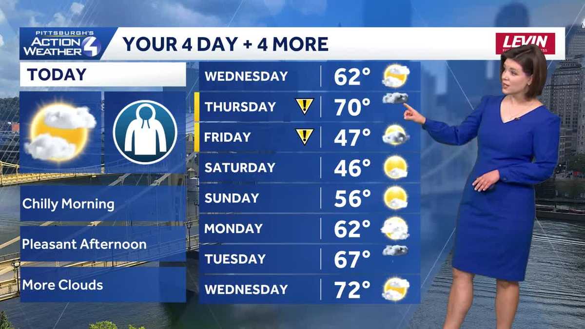
Conditions remain quiet with a warming trend through Thursday afternoon. We now have back-to-back Impact Days for the potential of flooding rain and isolated strong storms Thursday night through Friday morning.Warmer with more clouds todayMore clouds but warmer temperatures are on the way today. Temperatures will peak in the lower 60s around western Pennsylvania. Even nicer spring temperatures are ahead tomorrow with highs around 70 degrees Thursday.Back-to-back Impact DayThursday and Friday are both Impact Days. Isolated showers start popping up around lunchtime Thursday. The “impact” part of the day begins around sunset with area-wide rain featuring downpours and isolated strong storms.The wettest time frame will be overnight into Friday morning with periods of rain and an isolated thunder chance. We could see up to an inch of rain across western PA. Localized flooding is a concern for the Friday morning commute. The region will dry out by 8 a.m.Cooler but drier weekendTemperatures will be knocked back, again, into the 40s to wrap up the work and school week. The weekend will be dry and seasonably cool. Saturday will only be in the 40s before skipping to mid 50s on Sunday. A warming trend will take shape for the final days of March.TODAY: Warmer despite mostly cloudy skies, high: 62°.TONIGHT: Mostly cloudy and staying mild. Low: 53°.THURSDAY – Impact Day: Isolated showers after lunchtime. More rain, heavy at times, with isolated thunderstorms after sunset. Breezy and warmer, high: 70°, low: 42°.FRIDAY – Impact Day: Early morning rain. Much cooler with some clearing by the afternoon. High: 47°, low: 25°.SATURDAY: Seasonably chilly with sun and clouds. High: 46°, low: 29°.
PITTSBURGH —
Conditions remain quiet with a warming trend through Thursday afternoon. We now have back-to-back Impact Days for the potential of flooding rain and isolated strong storms Thursday night through Friday morning.
Warmer with more clouds today
More clouds but warmer temperatures are on the way today. Temperatures will peak in the lower 60s around western Pennsylvania. Even nicer spring temperatures are ahead tomorrow with highs around 70 degrees Thursday.

Hearst OwnedHearst
Pleasant temperatures to go along with mostly cloudy skies this afternoon.
Back-to-back Impact Day
Thursday and Friday are both Impact Days. Isolated showers start popping up around lunchtime Thursday. The “impact” part of the day begins around sunset with area-wide rain featuring downpours and isolated strong storms.

Hearst OwnedHearst
Around an inch of rain could lead to localized flooding by Friday morning. Isolated strong thunderstorms are also possible.
The wettest time frame will be overnight into Friday morning with periods of rain and an isolated thunder chance. We could see up to an inch of rain across western PA. Localized flooding is a concern for the Friday morning commute. The region will dry out by 8 a.m.

Hearst OwnedHearst
Area-wide heavy rain moves in late Thursday night and will exit by Friday morning.
Cooler but drier weekend
Temperatures will be knocked back, again, into the 40s to wrap up the work and school week. The weekend will be dry and seasonably cool. Saturday will only be in the 40s before skipping to mid 50s on Sunday. A warming trend will take shape for the final days of March.

Hearst OwnedHearst
A cool and dry weekend is on tap for western PA. Another warming trend is on the way to end March and begin April.
TODAY: Warmer despite mostly cloudy skies, high: 62°.
TONIGHT: Mostly cloudy and staying mild. Low: 53°.
THURSDAY – Impact Day: Isolated showers after lunchtime. More rain, heavy at times, with isolated thunderstorms after sunset. Breezy and warmer, high: 70°, low: 42°.
FRIDAY – Impact Day: Early morning rain. Much cooler with some clearing by the afternoon. High: 47°, low: 25°.
SATURDAY: Seasonably chilly with sun and clouds. High: 46°, low: 29°.