
Impact Days: Thursday night into Friday morning with heavy rain
Rain returns late Thursday with isolated flooding concerns through Friday morning.
A COMFORTABLE DAY OUTSIDE TEMPERATURES MADE IT INTO THE LOW 60S FOR TODAY, SO WE WILL BE SEEING THE CLOUDS WITH US OVERNIGHT INTO TOMORROW, BUT STILL VERY NICE OUT THERE. AND DRY. 61 THE HIGH TEMPERATURE TODAY. WE STARTED OFF AT 35 DEGREES. AS WE TAKE A LOOK AT THE TEMPERATURES RIGHT NOW, STILL FAIRLY MILD OUT THERE, 61 IN MONROEVILLE, 59 IN CRANBURY, 58 IN BUTLER, 59 AND 60 RIGHT NOW IN WAYNESBURG. AS WE GO THROUGH TOMORROW, IT WILL GET MUCH WARMER, HIGH RIGHT AROUND 70 DEGREES AS WE GET INTO THE EVENING HOURS. OF COURSE, WHAT WE’LL BE LOOKING OUT FOR WILL BE WHAT COMES AFTER THAT. AS WE GET INTO THE LATE NIGHT HOURS, THAT’S WHEN WE’LL HAVE THE POTENTIAL FOR SOME STRONG THUNDERSTORMS TO MOVE INTO THE AREA. AND THAT CERTAINLY COULD PACK A PUNCH AS THEY MOVE ACROSS THE REGION. AS WE TAKE A LOOK AT THE NEXT FOUR DAYS, YOU CAN SEE WE HAVE THE TWO IMPACT DAYS FOR THURSDAY NIGHT INTO FRIDAY MORNING. YOU CAN SEE HOW FAR THE TEMPERATURES DROP OFF AS THAT COLD FRONT ROLLS THROUGH OVERNIGHT FROM 70 FOR A HIGH TO 49 AND THEN DOWN TO 45 ON SATURDAY. NOW THE WEEKEND WILL BE NICE. JUST COLD ON SATURDAY AS WE START AT 25 DEGREES, THEN A HIGH OF 45 DEGREES. SUNDAY A LITTLE BETTER, 29 DEGREES AND A HIGH OF 56. SO SECOND HALF OF SUNDAY ACTUALLY WILL BE VERY NICE. TEMPERATURES WILL BE WARM NEXT WEEK, BUT THAT COMES WITH A COUPLE OF CHANCES FOR RAIN EARLY IN THE WEEK. SO HERE WE GO WITH SOME CLOUDS MOVING IN. COULD HAVE A COUPLE OF BREAKS EARLY ON REALLY THROUGH THE DAY. COULD HAVE AN ISOLATED SHOWER HERE OR THERE. THAT IS PRETTY MUCH IT. THE HEAVY STUFF DOESN’T COME IN UNTIL WE GET INTO THE LATE NIGHT HOURS. ABOUT 8:00 WE’LL HAVE THE FIRST SHOT OF SEEING SOME THUNDERSTORMS MOVING INTO THE REGION, AND THEY CERTAINLY COULD HAVE HEAVY RAIN LIGHTNING WITH THEM AS THEY PUSH THROUGH, AS WELL AS THE POTENTIAL FOR SOME STRONG WIND GUSTS, POSSIBLY SOME DAMAGING WIND AND HAIL. AS THIS MOVES THROUGH THE AREA, IT WILL SLOWLY SLIDE DOWN TO THE SOUTH. AS WE GO THROUGH THE DAY OR THE MORNING HOURS ON FRIDAY. BY THE TIME WE GET TO THE END OF THE DAY ON FRIDAY, I THINK WE MIGHT ACTUALLY SEE A LITTLE BIT OF SUNSHINE RETURNING TO THE AREA. THAT SUNSHINE PRETTY MUCH STAYS WITH US THROUGH THE WEEKEND. MOSTLY SUNNY TO PARTLY CLOUDY SKIES ON SATURDAY, AS WELL AS SUNDAY. WIND IS GOING TO PICK UP A BIT AS WE GO THROUGH THE DAY TOMORROW. WE ARE LOOKING AT WIND
Impact Days: Thursday night into Friday morning with heavy rain
Rain returns late Thursday with isolated flooding concerns through Friday morning.

Updated: 7:44 PM EDT Mar 25, 2026
Conditions remain quiet with a warming trend through Thursday afternoon. We now have back-to-back Impact Days for heavy rain and isolated strong storms, Thursday night through Friday morning.Back-to-back Impact DayThursday and Friday are both Impact Days. Isolated showers start popping up through Thursday. The “impact” part of the day begins at night with area-wide rain featuring downpours and isolated strong storms.The wettest time frame will be overnight into Friday morning with periods of rain and an isolated thunderstorm. We could see over an inch of rain across Western PA. Localized flooding is a concern for the Friday morning commute. The region will begin to dry out by 8 a.m.Cool weekend with sunshineTemperatures will be knocked back, again, into the 40s to wrap up the work and school week. The weekend will be dry and seasonably cool. Saturday will only be in the 40s before skipping to mid 50s on Sunday. Skies will be mostly sunny to partly cloudy. A warming trend will take shape for the final days of March.OVERNIGHT: Mostly cloudy and staying mild. Low: 53°.THURSDAY – Impact Day: Isolated showers through the day. More rain, heavy at times, with isolated thunderstorms at night. Breezy and warmer, high: 70°, low: 42°.FRIDAY – Impact Day: Early morning rain & t’storms. Much cooler with some clearing by the afternoon. High: 49°, low: 25°.SATURDAY: Seasonably chilly with sun and clouds. High: 45°, low: 29°.
PITTSBURGH —
Conditions remain quiet with a warming trend through Thursday afternoon. We now have back-to-back Impact Days for heavy rain and isolated strong storms, Thursday night through Friday morning.
Back-to-back Impact Day
Thursday and Friday are both Impact Days. Isolated showers start popping up through Thursday. The “impact” part of the day begins at night with area-wide rain featuring downpours and isolated strong storms.

Hearst OwnedHearst
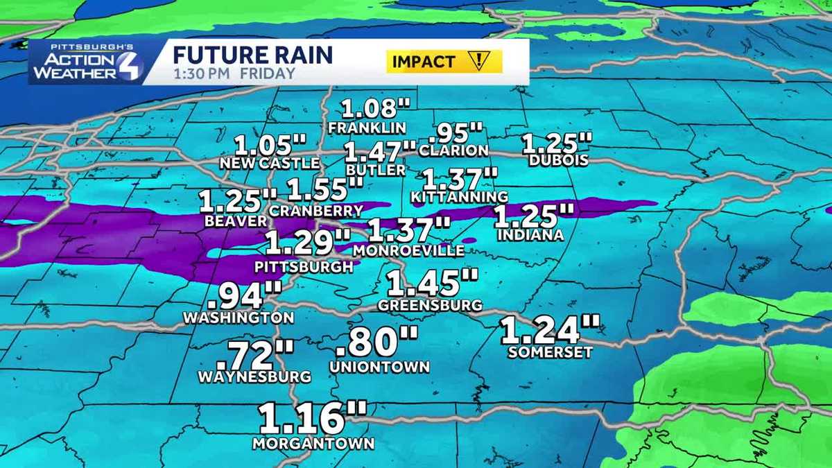
Around an inch of rain could lead to localized flooding by Friday morning. Isolated strong thunderstorms are also possible.
The wettest time frame will be overnight into Friday morning with periods of rain and an isolated thunderstorm. We could see over an inch of rain across Western PA. Localized flooding is a concern for the Friday morning commute. The region will begin to dry out by 8 a.m.

Hearst OwnedHearst
Area-wide heavy rain moves in late Thursday night and will exit by Friday morning.
Cool weekend with sunshine
Temperatures will be knocked back, again, into the 40s to wrap up the work and school week. The weekend will be dry and seasonably cool. Saturday will only be in the 40s before skipping to mid 50s on Sunday. Skies will be mostly sunny to partly cloudy.
A warming trend will take shape for the final days of March.

Hearst Owned
A cool and dry weekend is on tap for Western PA. Another warming trend is on the way to end March and begin April.
OVERNIGHT: Mostly cloudy and staying mild. Low: 53°.
THURSDAY – Impact Day: Isolated showers through the day. More rain, heavy at times, with isolated thunderstorms at night. Breezy and warmer, high: 70°, low: 42°.
FRIDAY – Impact Day: Early morning rain & t’storms. Much cooler with some clearing by the afternoon. High: 49°, low: 25°.
SATURDAY: Seasonably chilly with sun and clouds. High: 45°, low: 29°.