
Warm Thursday afternoon, rain tonight; much cooler Friday in south-central Pennsylvania
Highs will soar to the mid-70s today, then fall to the 40s Friday afternoon. Steady rain is expected overnight into early Friday.
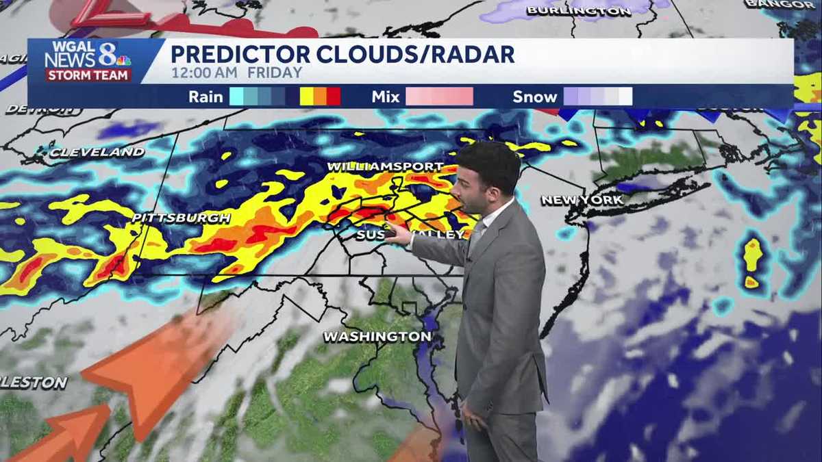
I’M GABRIEL THOMAS WGAL. NEWS 8. NOW THE WGAL NEWS EIGHT STORM TEAM FORECAST WITH METEOROLOGIST RYAN ARGENTINE. GOT SOME SUNSHINE FOR THE DAY TODAY SO FAR, BUT WE ARE GOING TO BE LOOKING AT SOME MORE UNSETTLED WEATHER WEATHER TO START TO COME THROUGH AS WE GET INTO LATER ON TONIGHT. SO WE’LL SEE MORE STEADY RAIN BEGIN TO RETURN. WE COULD SEE SOME TOTALS OF UP TO ABOUT A THREE QUARTERS OF AN INCH. MAYBE ISOLATED AREAS COULD SEE ABOUT AN INCH OF SOME RAIN, BUT WE COULD HEAR A FEW RUMBLES OF SOME THUNDER. AS THIS NEXT SYSTEM STARTS TO PUSH THROUGH, AND THEN THE RAIN TAPERS AS WE HEAD INTO EARLY FRIDAY. WE’LL STILL HAVE SOME LINGERING SHOWERS, BUT IT WILL BE A COOLER DAY OVERALL FOR FRIDAY AFTERNOON WITH TEMPERATURES FALLING TO THE 40S. THAT’S ALL THANKS TO A COLD FRONT THAT’S GOING TO START TO MOVE THROUGH, AND THAT’S GOING TO BE ALLOWING FOR SOME BREEZY CONDITIONS TO SETTLE IN. AND THEN WE’LL HAVE A DRY WEEKEND. SO IT WILL BE COOL AND BREEZY TO START, BUT WILL BE MUCH MORE SEASONABLE. SO I WOULD SAY A PLEASANT SUNDAY COMING UP. SO IF YOU HAPPEN TO HAVE ANY PLANS THIS WEEKEND, IT’S LOOKING DRY FOR YOU AND IT’S GOING TO BE A NICE WEEKEND, SO YOU CAN LOOK FORWARD TO THAT. PARTLY SUNNY FOR THE AFTERNOON. WE’LL SEE SOME INCREASING CLOUDS, WARM AND BREEZY. YOU CAN SEE HEADING UP FOR THE 70S LATER ON THIS AFTERNOON, BUT WE’LL HAVE THAT BREEZE OUT OF THE SOUTHEAST TURNING SOUTHWEST, AND THAT WILL BE BETWEEN 10 AND 20MPH. THEN WE’LL SEE SOME RAIN DEVELOPING TONIGHT. COULD HEAR A FEW RUMBLES OF SOME OF THAT THUNDER. IT WILL BE MILD AND BREEZY, 50 TO 54 DEGREES AND THEN TEMPERATURES. THEY’RE STILL GOING TO BE GOING DOWN. AS WE HEAD INTO TOMORROW. WE’LL SEE TEMPERATURES GET INTO THE LOWER 50S FOR THE AFTERNOON. WE’LL SEE MOSTLY CLOUDY CONDITIONS, BUT THOSE MORNING SHOWERS WILL BEGIN TO TAPER. WE’LL HAVE COOLER AND BREEZY CONDITIONS AND A STEADY NORTHWESTERLY BREEZE BETWEEN 10 AND 20MPH. SO WE’RE INTO THE MID 60S FOR THE MAJORITY OF US, WITH 68 IN GETTYSBURG, 6066 IN LEWISTOWN, 65 IN LEBANON AND HARRISBURG. AT THIS TIME, WE’RE 71 IN YORK. SO CERTAINLY FEELING MILD. AND WE. AND IT’S ALL THANKS TO THE SOUTHERLY BREEZE COMING IN ABOUT 12 MILES AN HOUR FOR YORK, GETTYSBURG AND CHAMBERSBURG. BUT ELSEWHERE, I’D SAY BETWEEN 5 AND 10MPH IS WHERE WE’RE STARTING TO GET THAT BREEZE. WE’LL. STAUNTON LIVE RADAR NETWORK. MOST OF IT’S. MOST OF THE AREA IS QUIET RIGHT NOW. SEEING BLUE SKIES. SEEING SOME HIGH LEVEL CLOUDS PASSING BY ON THE SATELLITE IMAGERY THERE. BUT THEN ONCE WE GET INTO LATER THIS EVENING, THAT’S WHEN WE’LL START TO SEE THE OUTSKIRTS OF THIS NEXT SYSTEM START TO PUSH THROUGH. YOU CAN SEE SOME OF THESE HEAVIER CELLS BEGINNING TO MOVE IN FROM THE NORTHWEST AND MOVING SOUTHEAST. AND HERE COMES THE THE, THE BIGGER SWATH OF SOME SHOWERS YOU CAN SEE COULD BE HEAVIER AT TIMES. YOU CAN SEE SOME OF THE REDS IN THERE COULD BE ASSOCIATED WITH SOME THUNDER AS WELL. NOT NOT RULING THAT OUT FOR LATER ON TONIGHT. GETTING INTO EARLY TOMORROW. YOU SEE JUST SOME OF THE MODERATE POCKETS OF SOME RAIN AS THAT COLD FRONT BEGINS TO MOVE THROUGH. BUT THE MAJORITY OF THAT RAIN, YOU SEE THE TIME STAMP ENDING BY 12 NOON ON FRIDAY. BUT THIS COLD FRONT, IT’S GOING TO BE ALLOWING FOR BLUSTERY CONDITIONS START TO MOVE THROUGH. YOU CAN SEE SOME CLEARING IN THE WAKE OF THAT FRONT. ONCE WE GET INTO LATER IN THE EVENING FRIDAY, YOU CAN SEE HIGH PRESSURE DOES START TO BUILD IN AND THAT’S GOING TO HELP CLEAR OUR SKIES TO START THE TO START THE WEEKEND COMING UP. BUT HERE’S THE PREDICTOR RAINFALL IN TERMS OF RAINFALL, IN TERMS OF RAINFALL AMOUNTS ABOUT JUST A LITTLE OVER HALF AN INCH OF SOME RAIN, POSSIBLY FOR HARRISBURG. BUT ACROSS THE AREA, I’D SAY BETWEEN A HALF INCH, MAYBE ISOLATED ONE INCH MARKS. IN SOME AREAS, YOU CAN SEE MILD CONDITIONS. AS WE GET INTO THE NEXT WEEK. TWO GOT 70S ON TAP FOR US FOR TUESDAY AND WEDNESDAY OF NEXT WEEK, GETTING DOWN TO THE 40S
Warm Thursday afternoon, rain tonight; much cooler Friday in south-central Pennsylvania
Highs will soar to the mid-70s today, then fall to the 40s Friday afternoon. Steady rain is expected overnight into early Friday.

Updated: 12:29 PM EDT Mar 26, 2026
We’ll see partly to mostly sunny skies today before before clouds increase this evening. Temperatures will quickly warm from the 40s to the 70s by afternoon, thanks to 10-20 mph southerly winds. Average highs are in the mid-50s.An evening shower or thunderstorm is possible, but most of the rain will hold off until after dark. Expect widespread rain tonight. Rain could be moderate to briefly heavy at times, and you may hear rumbles of thunder. Rain totals will range from 0.25″ to 0.75″ for most of the Susquehanna Valley.Rain will taper to showers around sunrise Friday. A few showers may linger in the afternoon and evening, especially south of the PA Turnpike, as a cold front slowly moves southeast. Temperatures will fall from the 50s in the morning to the 40s by afternoon, as colder air moves in from the northwest behind the front. Expect sustained winds at 10-20 mph.The last weekend of March will be dry. Look for partly sunny and breezy conditions Saturday. Highs will be cool, in the mid-40s. Temperatures will climb to the mid-50s Sunday under mostly sunny skies.Scattered showers are possible Monday and Tuesday with temperatures continuing to warm from the 60s to 70s. Isolated showers are possible Wednesday with highs in the low 70s.As a cold front approaches at the end of the week, rain chances go up Thursday into Friday. Temperatures will remain above average, near 60 degrees.
We’ll see partly to mostly sunny skies today before before clouds increase this evening. Temperatures will quickly warm from the 40s to the 70s by afternoon, thanks to 10-20 mph southerly winds. Average highs are in the mid-50s.
An evening shower or thunderstorm is possible, but most of the rain will hold off until after dark. Expect widespread rain tonight. Rain could be moderate to briefly heavy at times, and you may hear rumbles of thunder. Rain totals will range from 0.25″ to 0.75″ for most of the Susquehanna Valley.
Rain will taper to showers around sunrise Friday. A few showers may linger in the afternoon and evening, especially south of the PA Turnpike, as a cold front slowly moves southeast. Temperatures will fall from the 50s in the morning to the 40s by afternoon, as colder air moves in from the northwest behind the front. Expect sustained winds at 10-20 mph.
The last weekend of March will be dry. Look for partly sunny and breezy conditions Saturday. Highs will be cool, in the mid-40s. Temperatures will climb to the mid-50s Sunday under mostly sunny skies.
Scattered showers are possible Monday and Tuesday with temperatures continuing to warm from the 60s to 70s. Isolated showers are possible Wednesday with highs in the low 70s.
As a cold front approaches at the end of the week, rain chances go up Thursday into Friday. Temperatures will remain above average, near 60 degrees.