
We now have back-to-back Severe Weather Alert Days for heavy rain and severe to strong storms tonight through Friday morning.Back-to-back Severe Weather Alert DaysToday and Friday are both Alert Days. Isolated showers start popping up through the afternoon. The strong to severe storms start to move in after 8pm and continue into early Friday morning. The wettest time frame will be overnight into Friday morning with periods of rain and isolated strong to severe thunderstorms. We will likely see over an inch of rain for all of Western PA with locations between Interstate 80 and Interstate 70 seeing an inch and a half to two inches. Localized flooding is a concern for the Friday morning commute. The region will begin to dry out by 8 a.m.Cool weekend with sunshineTemperatures will be knocked back, again, into the 40s to wrap up the work and school week. The weekend will be dry and seasonably cool. Saturday will only be in the 40s before skipping to the mid 50s on Sunday. Skies will be mostly sunny to partly cloudy.A warming trend will take shape for the final days of March. Rain chances return next week as temperatures warm.TODAY – Severe Weather Alert Day: Isolated showers through the day. More rain, heavy at times, with isolated thunderstorms at night. Breezy and warmer, high: 74°, low: 42°.FRIDAY – Severe Weather Alert Day: Early morning rain then much cooler with some clearing by the afternoon. High: 49°, low: 25°.SATURDAY: Seasonably chilly with sun and clouds. High: 45°, low: 29°.SUNDAY: Partly cloudy and seasonal. High: 56°, low: 43°.
PITTSBURGH —
We now have back-to-back Severe Weather Alert Days for heavy rain and severe to strong storms tonight through Friday morning.
Back-to-back Severe Weather Alert Days
Today and Friday are both Alert Days. Isolated showers start popping up through the afternoon. The strong to severe storms start to move in after 8pm and continue into early Friday morning.

Hearst Owned
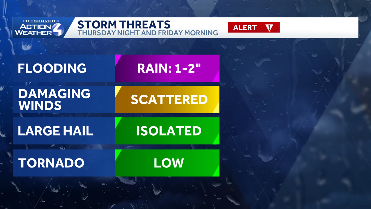
Flooding remains our biggest concern with rain and storms tonight. All modes of severe weather are possible.
The wettest time frame will be overnight into Friday morning with periods of rain and isolated strong to severe thunderstorms. We will likely see over an inch of rain for all of Western PA with locations between Interstate 80 and Interstate 70 seeing an inch and a half to two inches. Localized flooding is a concern for the Friday morning commute. The region will begin to dry out by 8 a.m.

Cool weekend with sunshine
Temperatures will be knocked back, again, into the 40s to wrap up the work and school week. The weekend will be dry and seasonably cool. Saturday will only be in the 40s before skipping to the mid 50s on Sunday. Skies will be mostly sunny to partly cloudy.
A warming trend will take shape for the final days of March. Rain chances return next week as temperatures warm.

Hearst Owned
Severe Weather Alert Days Thursday and Friday before a dry and quiet weekend. Temperatures warm with rain chances each day next week.
TODAY – Severe Weather Alert Day: Isolated showers through the day. More rain, heavy at times, with isolated thunderstorms at night. Breezy and warmer, high: 74°, low: 42°.
FRIDAY – Severe Weather Alert Day: Early morning rain then much cooler with some clearing by the afternoon. High: 49°, low: 25°.
SATURDAY: Seasonably chilly with sun and clouds. High: 45°, low: 29°.
SUNDAY: Partly cloudy and seasonal. High: 56°, low: 43°.