
Chillier through the evening; more seasonable for Sunday for south-central Pennsylvania
Temps have been unseasonably chilly for this time of the year; temps for this time in March should be around 56°. Although a wind shift for tomorrow will allow for the mid 50s to return. An active pattern is setting up for next week with most days having a chance for showers
SOCIETY, YOU KIND OF HAVE TO BE THE ONE TO BRING THE CHANGE. NOW, THE WGAL NEWS EIGHT STORM TEAM FORECAST WITH METEOROLOGIST RYAN ARGENTI BEAUTIFUL BLUE SKIES ACROSS SUSQUEHANNA VALLEY. A LITTLE BIT OF A BREEZE THOUGH. I’LL SAY TEMPERATURES, THOUGH A LITTLE CHILLIER THAN AVERAGE FOR THIS TIME OF THE YEAR. USUALLY WE EXPECT RIGHT AROUND THE MID 50S FOR TEMPERATURES FOR THIS TIME IN MARCH, ALMOST GETTING INTO APRIL HERE IN THE NEXT, NEXT FEW DAYS. BUT YOU CAN SEE GETTYSBURG, SEE SOME OF THE BLUE SKIES IN THE BACKGROUND, SEE SOME PEOPLE WALKING OUT ON THE STREETS. SO CERTAINLY A NICE DAY. JUST MAYBE A LIGHT JACKET WILL PROBABLY BE PROBABLY BE NECESSARY FOR NOW. 50 DEGREES. GOT SOME PARTLY SUNNY CONDITIONS WITH A WESTERLY BREEZE RIGHT AROUND 13MPH. IF YOU’RE TUNING IN FROM GETTYSBURG, BUT CHILLIER AND LESS BREEZY INTO OUR SATURDAY. AND THEN AS WE HEAD INTO THE SECOND HALF OF THE WEEKEND, MORE SEASONABLE WILL BE PLEASANT INTO THE MID 50S. BUT THEN WE’RE LOOKING AT SOME MORE RAIN CHANCES AND SOME PRETTY WILD TEMPERATURE SWINGS AS WE GET INTO, ESPECIALLY THE MIDDLE OF THE WEEK, WHERE WE’LL GO FROM THE 70S DOWN TO THE 50S. SO YOU’LL SEE THAT HERE IN THE TEN DAY FORECAST IN JUST A FEW MINUTES. SO WE’LL BE MOSTLY CLEAR FOR THE REST OF THIS EVENING WITH DIMINISHING WINDS OUT OF THE WEST NORTHWEST, CERTAINLY CHILLIER INTO THE UPPER 30S, 26 TO 30 DEGREES. SO I WOULD I WOULD SAY THIS IS A COLD, BORDERLINE CHILLY OR BORDERLINE COLD. I WOULD SAY FOR TONIGHT WITH PARTLY CLOUDY CONDITIONS, WITH A CALMER WEST NORTHWESTERLY BREEZE RIGHT AROUND FIVE MILES PER HOUR. THEN FOR TOMORROW, BREEZE KICKS BACK UP. STILL PLEASANT THOUGH, I’LL SAY WITH THE SUN AND SOME CLOUDS OR WITH A MIX OF SOME SUN AND CLOUDS. I SHOULD SAY 54 TO 58 DEGREES FOR THE AFTERNOON. BUT CHECK THIS TEMPERATURE TREND OUT. LOOK AT THIS. GETTING INTO THE MID 50S, MID 60S, UP TO THE MID 70S. BY THE TIME WE GET TO TUESDAY WEDNESDAY RIGHT AROUND 74, DROPPING DOWN TO 56 DEGREES FOR OUR THURSDAY. AND ADDITIONALLY WHAT’S ALSO GOING UP ARE THESE RAIN CHANCES FOR MONDAY. LOOKING AT A LATE CHANCE OF SOME SHOWERS NOW MOST OF THE DAY FOR MONDAY I BELIEVE IS GOING TO BE DRY. I THINK IT’S A REAL LATE INTO THE EVENING, EVEN INTO MONDAY NIGHT. THAT’S WHEN WE’LL START TO SEE THAT SHOWER CHANCE START TO INCREASE. AND THEN WE’LL SEE SOME EARLY SHOWERS FOR TUESDAY. I’M KEEPING MY EYE ON ON WEDNESDAY AFTERNOON. THERE COULD BE A CHANCE TO SEE SOME THUNDERSHOWERS, WHICH WE’LL TALK ABOUT HERE IN JUST A SECOND. TEMPERATURES IN THE MID 40S ACROSS THE MAJORITY OF THE AREA. YOU CAN SEE 43 THOUGH IN LEWISTOWN, 47 IN CHAMBERSBURG, 50 DEGREES IN GETTYSBURG. GOT THAT WEST NORTHWESTERLY BREEZE RIGHT AROUND 15, MAYBE 20MPH SO FAR. BUT AS WE GO THROUGH THE REST OF THIS EVENING, YOU CAN SEE WINDS WILL REMAIN CALM DURING THE OVERNIGHT PERIOD AND THEN PICK BACK UP ONCE WE GET TO SUNDAY AFTERNOON. YOU CAN SEE BETWEEN 10 AND 15MPH. IN GENERAL, SOME, SOME, SOME AREAS MAY GUST TO 20, MAYBE 25MPH FOR THE AFTERNOON. SO STORM TEAM LIVE RADAR NETWORK ALL IS QUIET THANKS TO SPRAWLING HIGH PRESSURE DOWN TOWARDS OUR SOUTHWEST. THAT’S GOING TO REMAIN JUST TOWARDS OUR SOUTH. AND THEN AS IT SHIFTS OUT TO SEA, IT’S GOING TO START TO FILTER IN OR USHER IN SOME MILDER AIR FROM THE SOUTH. AND THAT’S GOING TO BE THAT’S WHAT’S GOING TO ALLOW TEMPERATURES TO REBOUND TO THE MID 50S. NOW WE COULD SEE A MIX OF SOME SUN AND CLOUDS. SOME COMMUNITIES MAY SEE MORE SUN THAN OTHERS. AS WE HEAD INTO OUR SUNDAY. AND ALSO OUR MONDAY WILL BE MOSTLY SUNNY. IT LOOKS LIKE THE START, BUT WE DO CLOUD BACK UP ONCE WE GET INTO OUR MONDAY, ESPECIALLY GETTING INTO LATE IN THE EVENING JUST AHEAD OF THIS WARM FRONT, AS YOU CAN SEE, IS WHAT’S HELPING TO GET THOSE CLOUDS TO INCREASE ONCE AGAIN. SO TEMPERATURES INTO THE MID 50S FOR OUR SUNDAY 66 FOR MONDAY, 76 FOR OUR TUESDAY 74. BUT NOTICE THIS BIG TEMPERATURE DROP ONCE AGAIN WITH THIS BIG TEMPERATURE DROP TELLS ME THERE COULD BE A COLD FRONT. MAY ALLOW FOR SOME INSTABILITY IN THE MIX ONCE WE GET INTO WEDNESDAY AFTERNOON. SO THAT DOES TELL ME THAT THERE MAY BE SOME SIGNALS TO SOME THUNDERSHOWERS ONCE WE GET INTO THE MIDDLE OF NEXT WEEK. SO I DID PUT THAT ICON THERE AND LET THAT CHANCE FOR SOME THUNDERSHOWERS WEDNESDAY AFTERNOON. AND ALSO GETTING POTENTIALLY INTO LATE WEDNESDAY EVENING. BUT LOOK AT THIS. CAN’T COMPLAIN ABOUT THE 70S THOUGH. WE ARE IN NEED OF SOME RAIN, SO IT IS VERY NICE TO SEE SOME SHOWERS FOR THE MAJORITY OF THE WEEK FOR EASTER SUNDAY. STILL LOOKING AHEAD, IT DOES LOOK A LITTLE BIT UNSETTLED. WE’LL BE INTO T
Chillier through the evening; more seasonable for Sunday for south-central Pennsylvania
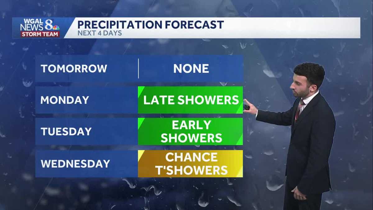
Temps have been unseasonably chilly for this time of the year; temps for this time in March should be around 56°. Although a wind shift for tomorrow will allow for the mid 50s to return. An active pattern is setting up for next week with most days having a chance for showers

Updated: 6:31 PM EDT Mar 28, 2026
Thanks to an area of high pressure, dry weather remains for the rest of the evening. Mainly clear skies will persist through the evening into tonight. Temperatures will be chillier than average, dropping through the upper 30s. Winds will begin to relax throughout the evening. Tonight, some clouds bubble up overnight. We’ll see partly cloudy conditions through the overnight period. Temperatures will bottom out in the upper 20s with light & variable winds.Sunday, expect a mix of sunshine and clouds from time to time. Temperatures will moderate back to the mid-50s. Winds will shift and become southerly with breezy conditions expected between 10-15 mph.SEVERAL RAIN CHANCES AND BIG TEMPERATURE SWINGSHeading into the work week, Monday is mainly dry with showers possible towards evening. Highs return to the mid 60s. With a warm front lifting through late, there may be a few showers late Monday night. A better chance for showers is overnight until early Tuesday. The wet weather moves out leaving partly sunny skies, and much warmer temperatures in the mid to upper 70s. Rain chances go up Wednesday, as a cold front pushes through the Valley. Highs are still warm in the lower 70s, but chillier air pushes in behind the departing system. There may be a chance for storms Wednesday afternoon.COOLER WITH MORE RAIN CHANCESCooler temperatures prevail Thursday with highs back to the 50s. The next system brings back a chance for showers in the evening, with a better chance of rain on Good Friday. Highs will struggle to reach 50 degrees.EASTER WEEKENDUnfortunately, shower chances are possible both Saturday and Sunday. It’s difficult to determine this far out which day will be the wettest. Highs will remain near or slightly above average in the low 60s.Have a great rest of your Saturday evening!~ Ryan
Thanks to an area of high pressure, dry weather remains for the rest of the evening. Mainly clear skies will persist through the evening into tonight. Temperatures will be chillier than average, dropping through the upper 30s. Winds will begin to relax throughout the evening.
Tonight, some clouds bubble up overnight. We’ll see partly cloudy conditions through the overnight period. Temperatures will bottom out in the upper 20s with light & variable winds.
Sunday, expect a mix of sunshine and clouds from time to time. Temperatures will moderate back to the mid-50s. Winds will shift and become southerly with breezy conditions expected between 10-15 mph.
SEVERAL RAIN CHANCES AND BIG TEMPERATURE SWINGS
Heading into the work week, Monday is mainly dry with showers possible towards evening. Highs return to the mid 60s. With a warm front lifting through late, there may be a few showers late Monday night.
A better chance for showers is overnight until early Tuesday. The wet weather moves out leaving partly sunny skies, and much warmer temperatures in the mid to upper 70s.
Rain chances go up Wednesday, as a cold front pushes through the Valley. Highs are still warm in the lower 70s, but chillier air pushes in behind the departing system. There may be a chance for storms Wednesday afternoon.
COOLER WITH MORE RAIN CHANCES
Cooler temperatures prevail Thursday with highs back to the 50s. The next system brings back a chance for showers in the evening, with a better chance of rain on Good Friday. Highs will struggle to reach 50 degrees.
EASTER WEEKEND
Unfortunately, shower chances are possible both Saturday and Sunday. It’s difficult to determine this far out which day will be the wettest. Highs will remain near or slightly above average in the low 60s.
Have a great rest of your Saturday evening!
~ Ryan