
Active pattern setting up for the week; warmer temperatures on tap for south-central Pennsylvania
Breezy winds out of the southwest continue to pump in warmer air and highs climb to the 60s and 70s early in the week.
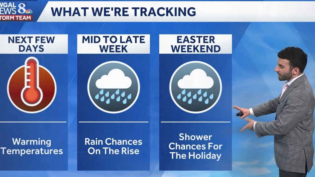
Lancaster sky cam right now we’re looking at blue skies across the Susquehanna Valley, seeing some high clouds beginning to work their way in, but you can see temperatures right into the mid-50s across the area. Still have that persistent southerly breeze, uh, right around 16 MPH. Some areas gusted to right around 20 to 25 MPH, uh, earlier this afternoon. But for the next few days, looking at some warming temperatures, Rain chances will be on the rise once we get into the middle to late. Next week or late this week I should say, but then as we head into the weekend, shower chances are on tap for the holidays. So just keep this in mind if you have any plans for Easter Sunday, we are looking at *** chance of seeing some showers for that time. So temperatures today hit *** high of 59 degrees. Usually we expect 56 for this time of the year, so we’re right around par, I would say. In terms of earlier this morning we hit 30 degrees. 36 is what we expect for this time of the year in March. But no rainfall was, uh, was observed at Harrisburg International Airport. So it will remain mainly clear for the next couple of hours here and then we’ll start to see those increasing clouds late in the evening. Still remaining breezy out of the southwest. I’d say 10, *** 10 and 15 mile per hour breeze remaining into the lower 50s. Then we’ll bottom out towards the mid-40s overnight tonight. Still have that southerly 10 to 15 mile per hour breeze, but we will be partly cloudy and then eventually become mostly cloudy. for tomorrow. Now there is *** chance of seeing some on and off showers. There’s some bubbles of energy that are gonna kind of pass by the valley and also *** bit of *** system that’s gonna be nearby is going to allow for *** chance of some on and off showers, but certainly milder, I’ll say 64 to 68 degrees for the afternoon. And oh yes, so it’s this time of the year, folks, all the pollen in the air. Oh yeah, breathe it in. I’m just kidding, but pollen levels, trees, and the grasses. It is moderate for tomorrow. Not sure if anybody else is having issues with the pollen, but at least I am. Uh, but mold levels, they’re low. Air quality is moderate, UV index, that is low with *** 50 minute burn time for the afternoon. We can see *** bit of an active pattern as we head into the next several days with the main, uh, or the, the, uh, the best, uh, probability of seeing these showers will be Wednesday, Thursday, and Friday. So basically in the middle to end of the work week coming up. So you can see upper 50s for most areas were 56 in Lancaster, 59 in York, Harrisburg, Lebanon, Carlisle into the lower 60s for Chambersburg, Gettysburg, and even Lewistown. So certainly feeling *** little bit, I’d say seasonable for the evening so far, and we still have that, I would say *** refreshing southerly breeze between 10 and 15 MPH generally across most of the area. So here’s Storm Team Live Radar Network. All is quiet, but you can see there’s some return. Off of the radar that’s from the State College radar that we have, uh, highlighted here, but this isn’t, I haven’t gotten any rain reports from this small swath, so this is, this is most likely just some upper level moisture that the radar is just returning. So just really looking at these clouds that are gonna start to move in as we head into the overnight period. But here comes that chance of some on and off showers as we head into our Monday morning. Look at this, it’s an on and off shower chance as we head into the uh. Into the afternoon into the evening we do start to briefly clear up as you can see Predictor highlights this, but then as we head into Tuesday, *** little bit of *** swath of some showers passes towards our north, but I will say that we could see ***, *** little, *** little bit of uh some action from this swath of showers may get just clipped, especially for our northern communities, uh, in the Susquehanna Valley. But as that starts to shift, we’ll see some partly sunny conditions develop for Tuesday. And here comes that warmer air from the south that’s going to be ushering in temperatures getting into the 70s, so the warmer air will allow temperatures to reach the upper 70s. So 76 degrees for your Wednesday. Also going to note, we are looking at *** chance of some thundershowers for Wednesday afternoon. Then it’ll be *** cooler stretch from Thursday, Friday, and Saturday. And then there’s Easter Sunday. There is *** chance of some showers, but we’re going to continue to fine tune those details as we get closer to next weekend.
Active pattern setting up for the week; warmer temperatures on tap for south-central Pennsylvania
Breezy winds out of the southwest continue to pump in warmer air and highs climb to the 60s and 70s early in the week.

Updated: 7:40 PM EDT Mar 29, 2026
For the evening, expect skies to increase in cloud cover later with temperatures dropping through the lower 50s. Winds will remain breezy out of the southwest between 10-15 mph. Tonight, the breeze eases a bit, and clouds will decrease to partly cloudy skies. It will be mild in the low to mid 40s.WARMING UP EARLY WEEKA persistent wind from the southwest continues to transport warmer air. Despite more clouds Monday, highs reach the mid 60s. A stray shower can’t be ruled out, otherwise it is a mainly dry day. There is a better chance to see a few showers overnight. They move out before sunrise Tuesday. We’re seeing brighter skies with some sunshine mixing in, and temperatures are warming into the upper 70s to near 80 with a growing southwest breeze.INCREASING RAIN CHANCESA cold front brings a better chance for showers on Wednesday, with a few thunderstorms possible. It stays warm, with highs in the low to mid 70s. Cooler temperatures prevail on Thursday with high temperatures stuck in the 50s. Plus, rain threatens both Thursday and Friday.EASTER WEEKENDUnfortunately, shower chances are possible both Saturday and Sunday. It’s difficult to determine this far out which day will be the wettest. As of now, Sunday is looking wetter. Highs will remain above average in the low 60s.Have a great rest of your Saturday evening!~ Ryan
For the evening, expect skies to increase in cloud cover later with temperatures dropping through the lower 50s. Winds will remain breezy out of the southwest between 10-15 mph.
Tonight, the breeze eases a bit, and clouds will decrease to partly cloudy skies. It will be mild in the low to mid 40s.
WARMING UP EARLY WEEK
A persistent wind from the southwest continues to transport warmer air. Despite more clouds Monday, highs reach the mid 60s. A stray shower can’t be ruled out, otherwise it is a mainly dry day. There is a better chance to see a few showers overnight. They move out before sunrise Tuesday. We’re seeing brighter skies with some sunshine mixing in, and temperatures are warming into the upper 70s to near 80 with a growing southwest breeze.
INCREASING RAIN CHANCES
A cold front brings a better chance for showers on Wednesday, with a few thunderstorms possible. It stays warm, with highs in the low to mid 70s. Cooler temperatures prevail on Thursday with high temperatures stuck in the 50s. Plus, rain threatens both Thursday and Friday.
EASTER WEEKEND
Unfortunately, shower chances are possible both Saturday and Sunday. It’s difficult to determine this far out which day will be the wettest. As of now, Sunday is looking wetter. Highs will remain above average in the low 60s.
Have a great rest of your Saturday evening!
~ Ryan