
Active pattern setting up for the week; warmer conditions arrive across south-central Pennsylvania
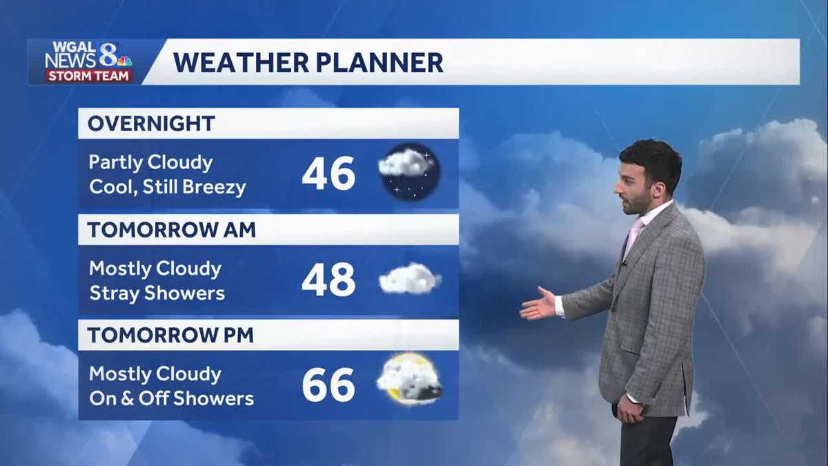
QUARANTINING AT CAPE CANAVERAL. NOW, THE WGAL NEWS EIGHT STORM TEAM FORECAST WITH METEOROLOGIST RYAN ARGENTI. AND HERE’S A LIVE LOOK OVER LANCASTER RIGHT NOW. WE HAD SOME CLEAR BLUE SKIES EARLIER, BUT YOU CAN SEE JUST IN THE SKIES STARTING TO SEE SOME OF THOSE CLOUDS BEGIN TO ROLL IN. NOW THEY’RE PARTLY CLOUDY AT THIS TIME, BUT WILL BECOME MOSTLY CLOUDY AS WE AS WE APPROACH TOMORROW MORNING. AND THEN EVENTUALLY WE’RE GOING TO SEE SOME CHANCES FOR SOME ON AND OFF SHOWERS. BUT HERE WE GO. IN TERMS OF THE ENTIRE SUSQUEHANNA VALLEY HARRISBURG, LANCASTER, YORK, LEBANON, CARLISLE, GETTYSBURG AND LEWISTOWN. I WOULD SAY GENERALLY MOST OF US ARE INTO THE MID TO UPPER 40S 55, THOUGH IF YOU’RE TUNING IN FROM GETTYSBURG RIGHT NOW, WEATHER HEADLINES FOR THE NEXT FEW DAYS, HIGHS WILL RETURN TO THE 60S AND THE 70S, AND THEN RAIN CHANCES WILL BE ON THE RISE ONCE AGAIN WITH THE HIGHEST CHANCES MID TO LATE THIS WEEK. AND THEN LOOKING AHEAD TO EASTER SUNDAY. FOLKS, IF YOU HAVE PLANS, I’M SURE A LOT OF FOLKS HAVE PLANS AT HOME. IT IS LOOKING A LITTLE BIT UNSETTLED, SO WE COULD BE LOOKING AT SOME MORE WET CONDITIONS RATHER THAN DRY. SO JUST KEEP THAT IN MIND IF YOU ARE TRYING TO MAKE SOME PLANS FOR FOR FAMILY THAT ARE GOING TO BE COMING OVER. TEMPERATURES RIGHT AROUND 59 DEGREES. THAT’S WHAT WE HIT EARLIER THIS AFTERNOON. 56. THAT’S WHAT WE WHAT WE EXPECT FOR THIS TIME OF THE YEAR, 30 DEGREES. THAT WAS EARLIER THIS MORNING’S LOW TEMPERATURE. BUT 36 IS WHAT WE EXPECT FOR THIS TIME OF THE YEAR. SO WEATHER PLANNER FOR THE REST OF THE NIGHT TONIGHT IT WILL BE PARTLY CLOUDY. STILL COOL. WILL STILL BE A LITTLE BIT BREEZY. WE’LL STILL HAVE THAT SOUTHWESTERLY BREEZE BETWEEN 10 AND 15MPH, BUT WE WILL BOTTOM OUT RIGHT IN THE MID 40S, THEN SLOWLY RISE TO THE UPPER 40S BY TOMORROW MORNING. THIS IS WHEN I’M EXPECTING A FEW STRAY SHOWERS. I DO BELIEVE THE MAJORITY OF THE AREA STAYS DRY, BUT THERE IS A CHANCE OF SEEING SOME OF THE MODEL GUIDANCE THAT I WAS ANALYZING. WE COULD BE SEEING SOME STRAY SHOWERS AND THEN TOMORROW AFTERNOON, STILL LOOKING AT A CHANCE OF SOME ON AND OFF SHOWERS WITH MOSTLY CLOUDY CONDITIONS. 66 DEGREES FOR TOMORROW AFTERNOON, BUT YOU CAN SEE A BIT OF AN UNSETTLED PATTERN AS WE HEAD INTO THE WEEK, ESPECIALLY AS WE GET INTO WEDNESDAY, THURSDAY AND FRIDAY WITH THE BEST CHANCE OF SOME SHOWERS. AND THEN WE’LL SEE THAT 40% CHANCE OF SHOWERS CLOSER TO SATURDAY AND SUNDAY, WITH SUNDAY BEING BEING THE BETTER HALF OF THE WEEKEND FOR FOR THE EASTER HOLIDAY TEMPERATURES INTO THE UPPER 40S. AS YOU CAN SEE, 48 IN HARRISBURG, 51 CARLISLE, 50 DEGREES. IN LEWISTOWN. YOU CAN SEE WINDS OUT OF THE SOUTH, GENERALLY BETWEEN 10 AND 15MPH, SOME AREAS RIGHT INTO THE SINGLE DIGITS RANGE FOR LANCASTER, YORK AND GETTYSBURG, JUST FOR AN EXAMPLE. BUT STORM TEAM LIVE RADAR NETWORK. SO LOOKS LIKE THAT THE RADAR IS A LITTLE BIT ON THE HIGHER SENSITIVITY SIDE. THAT’S WHY YOU’RE SEEING THIS LIKE SOME NOISE THAT YOU’RE SEEING COMING FROM THE RADAR SITE. BUT OVERALL, JUST SEEING SOME MAINLY CLOUDY CONDITIONS WITH SOME SHOWERS STARTING TO MAKE IT MAKE THEIR WAY IN TO THE COMMONWEALTH. BUT THAT’S FAR OUT TOWARDS WESTERN PENNSYLVANIA AT THIS TIME. NOT EXPECTING ANY OF THOSE CHANCES FOR SHOWERS TO REALLY COME IN UNTIL WE GET INTO TOMORROW MORNING AND ALSO INTO TOMORROW AFTERNOON. SO TIMING IT OUT FOR YOU AS WE GET INTO MONDAY AFTERNOON, LOOKING LIKE IT LOOKS LIKE A MAINLY DRY DAY, BUT THERE’S STILL THAT STRAY SHOWER CHANCE. CAN’T RULE THAT OUT. SO LEAVING THAT IN THE FORECAST FOR TOMORROW, THEN HEADING INTO YOUR TUESDAY TUESDAY MORNING LOOKING MOSTLY CLOUDY. BUT THEN HERE COMES ANOTHER CHANCE OF SOME SHOWERS AS WE GET INTO THE. AS WE GET INTO THE EVENING. BUT THE MAIN STORY HERE TOO IS WE’RE GETTING THIS WARMER AIR FROM THE SOUTH, USHERING INTO THE SUSQUEHANNA VALLEY. THAT’S WHAT’S GOING TO BE ALLOWING TEMPERATURES TO REACH THE UPPER 70S FOR TUESDAY AFTERNOON. 76 DEGREES FOR YOUR WEDNESDAY, THEN DROPPING DOWN TO THE 50S BY THURSDAY. NOTICE THIS DROP HERE 76 DOWN TO 58 DEGREES FOR THURSDAY. WE COULD BE SEEING A LITTLE BIT OF A STORMY PATTERN. SO I DID PUT IN A THUNDERSHOWER ICON FOR YOUR WEDNESDAY. KEEP THAT IN MIND. WE MAY SEE SOME THUNDER SHOWERS OR THUNDERSTORMS HEADING INTO WEDNESDAY AFTERNOON. BIT OF AN UNSETTLED WEEK HEADING INTO
Active pattern setting up for the week; warmer conditions arrive across south-central Pennsylvania

Updated: 11:07 PM EDT Mar 29, 2026
Tonight, the breeze eases a bit, and clouds will decrease to partly cloudy skies. It will be mild in the low to mid 40s.WARMING UP EARLY WEEKA persistent wind from the southwest continues to transport warmer air. Despite more clouds Monday, highs reach the mid 60s. A stray shower can’t be ruled out, otherwise it is a mainly dry day. There is a better chance to see a few showers overnight. They move out before sunrise Tuesday. We’re seeing brighter skies with some sunshine mixing in, and temperatures are warming into the upper 70s to near 80 with a growing southwest breeze.INCREASING RAIN CHANCESA cold front brings a better chance for showers on Wednesday, with a few thunderstorms possible. It stays warm, with highs in the low to mid 70s. Cooler temperatures prevail on Thursday with high temperatures stuck in the 50s. Plus, rain threatens both Thursday and Friday.EASTER WEEKENDUnfortunately, shower chances are possible both Saturday and Sunday. It’s difficult to determine this far out which day will be the wettest. As of now, Sunday is looking wetter. Highs will remain above average in the low 60s.Have a great rest of your Saturday night!~ Ryan
Tonight, the breeze eases a bit, and clouds will decrease to partly cloudy skies. It will be mild in the low to mid 40s.
WARMING UP EARLY WEEK
A persistent wind from the southwest continues to transport warmer air. Despite more clouds Monday, highs reach the mid 60s. A stray shower can’t be ruled out, otherwise it is a mainly dry day. There is a better chance to see a few showers overnight. They move out before sunrise Tuesday. We’re seeing brighter skies with some sunshine mixing in, and temperatures are warming into the upper 70s to near 80 with a growing southwest breeze.
INCREASING RAIN CHANCES
A cold front brings a better chance for showers on Wednesday, with a few thunderstorms possible. It stays warm, with highs in the low to mid 70s. Cooler temperatures prevail on Thursday with high temperatures stuck in the 50s. Plus, rain threatens both Thursday and Friday.
EASTER WEEKEND
Unfortunately, shower chances are possible both Saturday and Sunday. It’s difficult to determine this far out which day will be the wettest. As of now, Sunday is looking wetter. Highs will remain above average in the low 60s.
Have a great rest of your Saturday night!
~ Ryan