

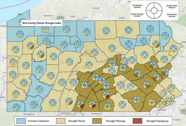
Recent rainfall has lessened the severity of the Lehigh Valley’s drought, but dry conditions persist virtually everywhere in eastern Pennsylvania and New Jersey, according to the latest drought update from the U.S. Geological Survey.
The USGS, which compiles climate and weather information from various sources, uses four categories to determine a region’s drought status: surface water (streams and rivers), ground water (soil moisture and observation well readings), the Palmer Drought Index, and precipitation. Unlike the other measures which are point-in-time type data, the Palmer Index is a long-term measure of an area’s aridity or moisture combining temperature, soil moisture, waterway and precipitation data.
More than 86 percent of the Allentown-Bethlehem-Easton MSA was in severe drought a month ago. That has decreased to about 42 percent. However, the remaining 58 percent of the region’s land area is in moderate drought, up from 14 percent a month ago.
On a county level, 56 percent of Lehigh is currently in moderate drought, with the remaining 44 percent in severe drought. Northampton is in better shape, with only 12.4 percent of is land area in severe drought, and the remaining 87.6 in moderate drought.
Look out below
Hydrologists and climatologists often use a water year rather than a calendar year to track water on and under the ground. The water year runs from Oct. 1 through Sept. 30, and more closely aligns with the natural cycle of water table replenishment and depletion that begins as the hot summer weather wanes and agricultural water use lessens.
Readings from official observation wells in Lehigh and Northampton counties show that recent precipitation is percolating down into water tables that had been at their lowest point in years. The two charts below illustrate the levels for the current water year. Readings measure how far the well is below surface level, meaning the lower the number, the higher the water level.
Although both wells indicate higher water tables in recent weeks, the Lehigh well is still significantly lower than its all-time average of 55.5 feet below ground. The latest readings show the water is 65 feet below Haafsville. The Northampton County well is above average for the first time in the water year, measuring 32.3 feet below ground at Jacobsburg State Park, 2.2 feet higher than the all-time average of 34.5 feet recorded at that location. That difference helps explain why Northampton County’s drought status is less severe than Lehigh’s.
Going with the flow
Surface waterways tend to respond more quickly to snow melt or rainfall, as shown in the discharge rates of the Lehigh River in Bethlehem and the Little Lehigh Creek in Allentown, two of the stations used in determining the area’s drought status. Discharge — or streamflow — is measured in cubic feet of water per second. A cubic foot is roughly 7.5 gallons of water, depending on temperature, salinity and other factors.
Both streams have recently moved several times more water than they did during the depths of winter, with the Little Lehigh ranging from 29.4 cubic feet (220 gallons) per second at the beginning of February to 133 cu. ft./s (995 gallons) on March 17. The Little Lehigh is the Lehigh River’s largest tributary, according to the Lehigh County Authority, collecting the flow of the Jordan Creek shortly before subsuming itself into the river at Canal Park in Allentown.
The Lehigh River had more than 58,000 gallons of water (7,780 cu. ft.) per second flowing in its bed on March 19, more than 16 times the discharge of its water year low recorded on Oct. 30.
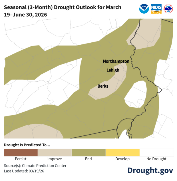
The stream flows and well depths are hopeful, and, although the National Weather Service predicts that drought conditions will persist in the region over the next month, they expect the drought to end for most of Northampton County and the northern half of Lehigh County by the end of June, according to their latest seasonal forecast.
National Weather Service
The National Weather Service predicts that the drought will improve or end for the Lehigh Valley by the end of June.
Cloudy with a chance of perspiration
In the meantime, the Lehigh Valley is expected to welcome April with its eponymous showers and unseasonably warm temperatures for the rest of the week. Here is the forecast:
Tuesday: Scattered showers and thunderstorms before 11 a.m., then isolated showers between 11 a.m. and 2 p.m., then a slight chance of showers and thunderstorms after 2 p.m. Mostly cloudy, with a high near 77 and a low around 64.
Wednesday: A chance of rain before 11 a.m., then a chance of rain and thunderstorms between 11 a.m. and 2 p.m., then rain likely and possibly a thunderstorm after 2 p.m. Mostly cloudy, with a high near 78 and a low around 53. Southwest wind around 10 mph, with gusts as high as 20 mph. Chance of precipitation is 70%. New rainfall amounts between a 10th and quarter of an inch, except higher amounts possible in thunderstorms.
Thursday: A chance of rain. Mostly cloudy, with a high near 66 and a low around 51. Chance of precipitation is 30%.
Friday: A chance of rain after 2 p.m. Mostly cloudy, with a high near 74 and a low around 58. Chance of precipitation is 40%.
Saturday: A chance of rain. Mostly cloudy, with a high near 76 and a low of 52. Chance of precipitation is 40%.
Sunday: Rain likely. Mostly cloudy, with a high near 69. Chance of precipitation is 60%.
U.S. Geological Survey
Recent rainfall has helped to alleviate, though not eliminate, the Lehigh Valley’s drought designation.