
Scattered Late PM & Evening Thunderstorms In South Central Pennsylvania
Highs will reach the 70s today, then fall to the 50s on Thursday.
ESTIMATE YET ON THE REPAIR. NOW, THE WGAL NEWS EIGHT STORM TEAM FORECAST, WITH METEOROLOGIST MIKE SUSKO. GOOD AFTERNOON EVERYONE. THE NEXT COUPLE OF HOURS SHOULD BE QUIET ACROSS THE SUSQUEHANNA VALLEY. UNLESS YOU’RE IN NORTHERN DAUPHIN COUNTY, YOU MAY SEE AN ISOLATED SHOWER HERE WITHIN THE NEXT 30 MINUTES OR SO. BUT THEN AS WE HEAD TOWARDS THE 4:00 5:00 HOUR, WE’RE GOING TO BE WATCHING FOR SOME SCATTERED SHOWERS AND THUNDERSTORMS TO DEVELOP ACROSS THE REGION, ESPECIALLY SOUTH OF THE PENNSYLVANIA TURNPIKE. AND THAT’S WHERE WE ALSO SEE THE BEST CHANCE FOR SOME STRONG THUNDERSTORMS AS WE GO THROUGH THE EVENING HOURS. WE’RE ALSO WATCHING FOR SOME HEAVY RAIN AS IT COMES IN FROM THE WEST. HERE ALONG THE FROM WEST TO EAST AROUND NINE, TEN AND 11:00 HERE. SO YOU’RE GOING TO GET A LITTLE BIT OF ON AND OFF PERIODS OF RAIN. IT’S NOT GOING TO BE STEADY RAIN. THE ENTIRE WINDOW THERE FROM 4 P.M. TO MIDNIGHT WILL BE ON AND OFF BREAKS. BUT IN THAT WINDOW OF OPPORTUNITY, SO TO SPEAK, WE COULD SEE SOME STRONG TO SEVERE THUNDERSTORMS. AND THAT’S WHY WE HAVE THAT SLIGHT RISK. LEVEL TWO OUT OF FIVE RISK ACROSS OUR SOUTHERN COUNTIES HERE, WHERE WE COULD SEE SOME OF THOSE STRONGER THUNDERSTORMS THAT MAY PRODUCE DAMAGING WIND GUSTS AND LOCALLY HEAVY RAIN IN OUR AREA. SO JUST SOMETHING TO BE AWARE OF AS YOU’RE GOING OUT LATER ON THIS EVENING. BUT RIGHT NOW, IF YOU WANT TO GRAB LUNCH OUTSIDE, WHY NOT? IT’S BEAUTIFUL HERE IN YORK AND ACROSS PARTS OF THE SUSQUEHANNA VALLEY, THERE’S ONLY ONE AREA THAT’S SEEING SOME SHOWERS AT THE MOMENT, AND THAT’S IN NORTHERN DAUPHIN COUNTY. WE’RE SEEING TEMPERATURES 74 IN YORK, 72 IN LANCASTER, AS WELL AS HARRISBURG, 81 ALREADY IN GETTYSBURG AND 68 UP IN LEWISTOWN. THERE’S A LITTLE MORE CLOUD COVER FOR OUR NORTHERN COUNTIES. THAT’S WHY YOU’RE SEEING THE COOLER TEMPERATURES THERE. HERE’S A LOOK AT THE RADAR. WE DO HAVE THAT SHOWER PUSHING THROUGH NORTHERN DAUPHIN COUNTY JUST OUTSIDE HARRISBURG AT THE MOMENT. ALSO SOME SPRINKLES THERE IN PARTS OF FRANKLIN OR EXCUSE ME, MIFFLIN AND PERRY COUNTY THERE NEAR PORT ROYAL. WE’RE ALSO SEEING SOME OF THOSE SPRINKLES. ZOOMING OUT, YOU CAN SEE TWO AREAS OF RAIN THAT WE’RE WATCHING, SOME SHOWERS DOWN TO THE SOUTHWEST. THIS IS GOING TO BE MOVING INTO OUR AREA AS WE GO THROUGH THE EVENING, AND WE NEED TO WATCH THAT FOR THE STRONG TO SEVERE THUNDERSTORM POTENTIAL. AND THEN WE ALSO HAVE THAT BATCH OF RAIN OFF TO THE WEST IN NORTHERN OHIO. SO AS WE GO THROUGH THE NEXT COUPLE OF HOURS, IT WILL BE QUIET. AND THEN AROUND 4:00 IS WHEN WE NEED TO START WATCHING THOSE SCATTERED SHOWERS AND THUNDERSTORMS POTENTIAL ACROSS THE SUSQUEHANNA VALLEY FROM 4:00 AGAIN UNTIL ABOUT MIDNIGHT. AFTER MIDNIGHT, SHOWERS WILL COME TO AN END. THERE WILL BE A COUPLE SHOWERS REMAINING AFTER MIDNIGHT, BUT THEY START TO WIND DOWN. WE’LL DROP BACK TO THE LOW 50S, AND THAT’S ACTUALLY GOING TO BE THE HIGH TOMORROW AS WELL. SO TEMPERATURES ARE GOING TO PEAK IN THE MORNING ON YOUR THURSDAY. AND THEN THEY DROP THROUGHOUT THE DAY. SO JUST KEEP THAT IN MIND AS YOU’RE MAKING PLANS TOMORROW. YOU’RE ACTUALLY GOING TO START OFF WARMER IN THE MORNING AND THEN END THE DAY A BIT COOLER WITH A MOSTLY CLOUDY SKY. SO HERE’S A LOOK AT THE PREDICTOR. WE HAVE THE SHOWERS AND THUNDERSTORMS PUSHING THROUGH AS WE GO THROUGH THE EVENING AND OVERNIGHT HOURS HERE. AND THEN AS WE GO INTO YOUR THURSDAY, WE WILL WATCH FOR A FEW MORE SHOWERS, THEIR EARLY MORNING HOURS. THE WARM FRONT WILL KIND OF HANG OUT JUST TO OUR SOUTH, MAYBE BRING US ANOTHER BATCH OF SOME SHOWERS TOMORROW EVENING AROUND 8:00, 9:00. AND THEN AS WE GO INTO FRIDAY, THAT WARM FRONT WILL LIFT TO THE NORTH AND WE SEE THE TEMPERATURES RESPOND ACCORDINGLY, GOING ALL THE WAY BACK UP TO THE 70S. SO A BRIEF COOLDOWN AFTER OUR 76. TODAY WE GET DOWN TO 52 TOMORROW. BUT AGAIN THE HIGH IT WILL BE IN THE MORNING. IT WILL DROP THROUGHOUT THE DAY. 74 FOR FRIDAY, 78 NEAR 80 DEGREES ON SATURDAY. BEAUTIFUL SATURDAY. SUNDAY WE HAVE SOME AFTERNOON SHOWERS LEAVING. RUMBLE OF THUNDER WITH A COLD FRONT COMING THROUGH. AND THEN WE’RE MORE SEASONABLE NEXT WEEK AND DRIER AS WELL. THE ENTIRE UPCOMING WORKWEEK LOOKIN
Scattered Late PM & Evening Thunderstorms In South Central Pennsylvania
Highs will reach the 70s today, then fall to the 50s on Thursday.

Updated: 1:42 PM EDT Apr 1, 2026
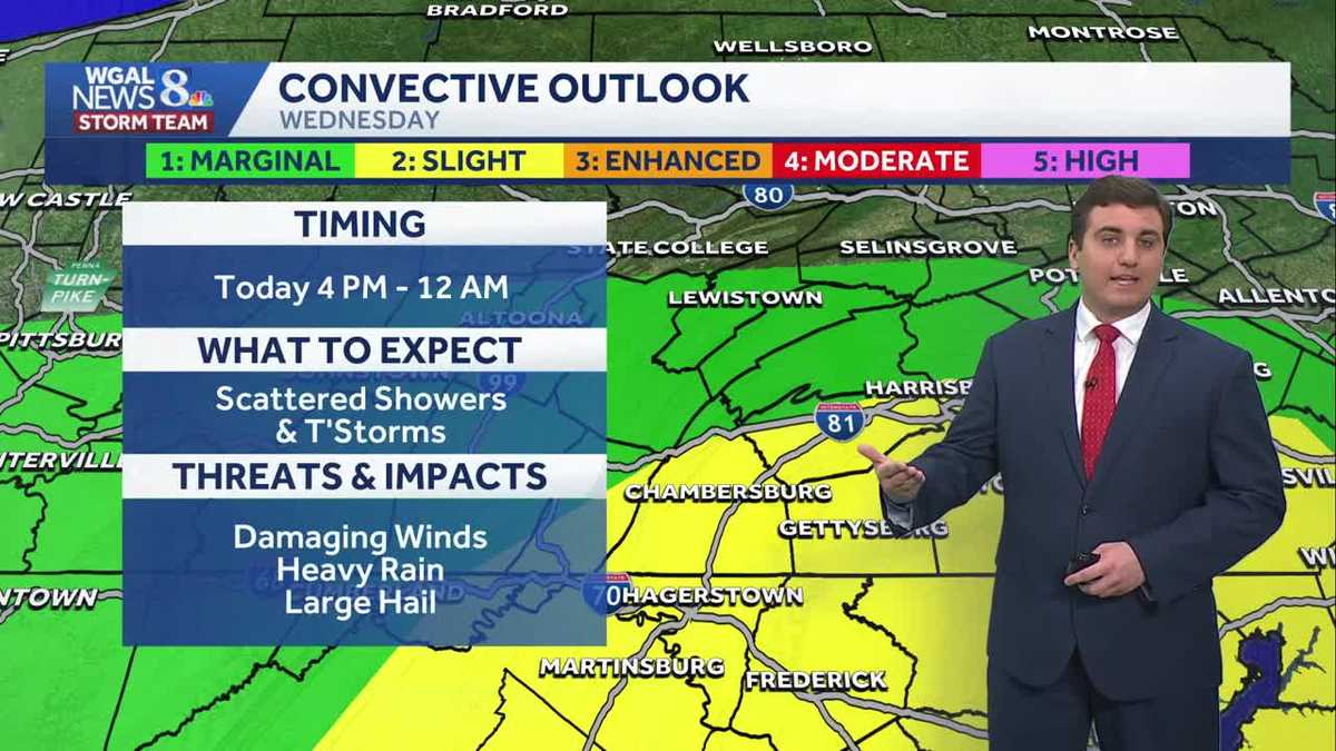
Good afternoon,Look for breaks of sun with highs in the mid-70s. We’ll have several dry hours before scattered showers and thunderstorms return toward evening, ahead of a cold front. Isolated and scattered thunderstorms may produce damaging wind gusts, heavy rain, and hail between 4 p.m. – 12 a.m Thursday.Tonight, lows will fall to the low-to-mid 50s, with showers ending.COOLER THURSDAY, WARMTH RETURNS FRIDAYThe cold front will settle along the PA/MD state line Thursday morning, leading to mainly cloudy skies and cooler temperatures. Temperatures will hover in the low 50s in the morning and afternoon, then drop to the upper 40s by evening. A few showers are possible, mainly later in the day.A warm front will lift north on Friday, and temperatures will rebound to the 70s. A few showers can’t be ruled out, but most of the day will be dry under partly to mostly cloudy skies.EASTER WEEKENDSaturday will be the warmer half of the weekend, with highs in the upper 70s and an isolated shower. Sunday will start dry, but an approaching cold front will bring widespread showers Sunday afternoon through early evening. Highs will reach the mid-60s.NEXT WEEKTemperatures will fall back to seasonable averages for early April. Expect highs in the mid-50s to low 60s under partly sunny skies. Lows will be cooler, in the 30s and 40s. Temperatures will trend warmer toward the end of the week.Have a great day!
Good afternoon,
Look for breaks of sun with highs in the mid-70s. We’ll have several dry hours before scattered showers and thunderstorms return toward evening, ahead of a cold front. Isolated and scattered thunderstorms may produce damaging wind gusts, heavy rain, and hail between 4 p.m. – 12 a.m Thursday.
Tonight, lows will fall to the low-to-mid 50s, with showers ending.
COOLER THURSDAY, WARMTH RETURNS FRIDAY
The cold front will settle along the PA/MD state line Thursday morning, leading to mainly cloudy skies and cooler temperatures. Temperatures will hover in the low 50s in the morning and afternoon, then drop to the upper 40s by evening. A few showers are possible, mainly later in the day.
A warm front will lift north on Friday, and temperatures will rebound to the 70s. A few showers can’t be ruled out, but most of the day will be dry under partly to mostly cloudy skies.
EASTER WEEKEND
Saturday will be the warmer half of the weekend, with highs in the upper 70s and an isolated shower. Sunday will start dry, but an approaching cold front will bring widespread showers Sunday afternoon through early evening. Highs will reach the mid-60s.
NEXT WEEK
Temperatures will fall back to seasonable averages for early April. Expect highs in the mid-50s to low 60s under partly sunny skies. Lows will be cooler, in the 30s and 40s. Temperatures will trend warmer toward the end of the week.
Have a great day!