
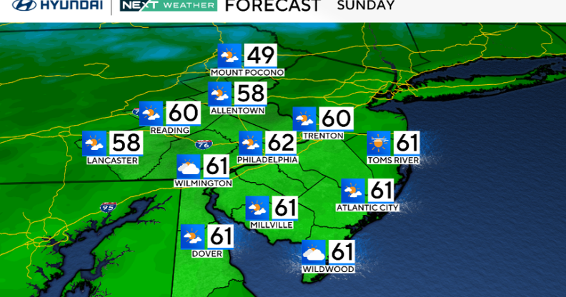
After a cold morning, with a frost advisory in effect for much of the area until 9 a.m., expect a pleasant, seasonable Sunday with sunshine returning by the afternoon and highs in the upper 50s to low 60s.
By early this week, the weather pattern will become more active. Low pressure develops off the Carolinas on Monday and tracks out to sea, followed by another system forming off the southern Mid-Atlantic Tuesday into Wednesday.

CBS News Philadelphia
This second storm could move north along the coast on Thursday, bringing gusty onshore winds, rain and coastal flooding concerns, especially for shore and back bay communities already affected by earlier storms.
Thursday will be the rainiest day, but this will NOT be anything like the coastal storm we were tracking two weeks ago.
Conditions will remain chilly through the end of the week before high pressure returns Friday into the weekend.
Tracking Hurricane Melissa’s path

As of a Sunday morning update from the National Hurricane Center, Melissa is now a Category 4 Hurricane with winds at 140 mph. The center of Melissa is located 120 miles south-southeast of Kingston, Jamaica, and is only moving west at 5 mph. It is projected to reach Category 5 status with winds at 160 mph overnight Sunday into Monday. It is then forecast to weaken slightly just before landfall on Jamaica early Tuesday morning as a powerful Category 4 hurricane with winds around 155 mph (157mph is Category 5).
Here’s your 7-day forecast:

CBS News Philadelphia
Sunday: Sun and clouds. High 62, Low 43.
Monday: More sunshine. High 60, Low 43.
Tuesday: Clouds and sun. High 60, Low 44.
Wednesday: Increasing clouds. High 62, Low of 44.
Thursday: Chance of showers. High 62, Low 45.
Friday: Chance of showers. High 62, Low 52.
Saturday: Seasonable Nov. start. High 63, Low 47.