
Pittsburgh: More rain tonight, Impact Day for Easter
Once the rain dries up, temperatures take a tumble to end the weekend.
THE 25TH. SO OBVIOUSLY LOTS GOING ON THERE. BUT TODAY THE MAIN TALKING LINE IS PIRATES BUC-EE’S GAME DAY TWO. HOW ARE WE LOOKING FOR IT? LATER. LOOKS REALLY GOOD OBVIOUSLY THIS MORNING THOUGH, IF YOU’RE UP AND MAYBE HEADING TO ONE OF YOUR AREA CREEKS AND STREAMS TO DO SOME TROUT FISHING. RAIN IS COMING DOWN BUT WE WILL DRY UP BEFORE TOO LONG. NOT EXACTLY FEELING LIKE SPRING, BUT MORE FULL ON MIDDLE OF BASEBALL SEASON WITH TEMPERATURES THAT WILL CHALLENGE A RECORD, INCLUDING HERE IN THE CITY OF PITTSBURGH. WE GO TO AN IMPACT DAY TONIGHT THROUGH THE START OF SUNDAY, AS WE ARE EXPECTING MORE AREA WIDE RAIN. TEMPERATURES EVENTUALLY WILL DROP AS WE GO THROUGH YOUR EASTER TOMORROW. FOR THE MEANTIME, THOUGH, STILL TRACKING SOME SHOWERS LEFT OVER FROM YESTERDAY. SOME OF THE HEAVIER RAIN PARTS FROM SHARPSBURG BACK TOWARDS PENN HILLS. WE CAN EVEN HEAR THAT HERE AT THE STATION IN WILKINSBURG. A FEW MORE BURSTS OF SOME HEAVIER RAIN HEADING UP THE ALLEGHENY VALLEY TOO. AS WE GET CLOSER TO THE LINE WITH ARMSTRONG AND BUTLER COUNTIES. MEANWHILE, BETWEEN SLIPPERY ROCK, ALSO KARNES CITY GETTING CLOSE TO THE MONOTONE IMAGE, DARKER AREAS, YOU’RE GOING TO FIND MORE OF THAT HEAVY RAIN. ANOTHER BURST OF MODERATE SHOWERS TRYING TO NOSE IN ACROSS LAWRENCE AND BEAVER COUNTIES, TOO. FOR THE EARLY RISERS HERE ON THIS SATURDAY, SHOWERS WILL CONTINUE TO TRACK TOWARDS THE NORTH AND EAST, SO PULLING AWAY FROM THE CITY OF PITTSBURGH AND EVEN JUST A FEW LITTLE DRIPS AND DRIZZLES AS WE LOOK CLOSER TO I-70 AND POINTS TOWARDS THE SOUTH AS YOU WORK THROUGH THE AFTERNOON, WE WILL SEE A FAST JUMP IN TEMPERATURES, CERTAINLY FEELING LIKE SUMMER HERE FOR THE FIRST WEEKEND OF APRIL, A HIGH OF 84 DEGREES. TODAY IS THE FORECAST THAT WOULD BEST A LONG STANDING RECORD OF 83 THAT DATES BACK TO 1882 IN PITTSBURGH. HERE’S YOUR 4-DAY PLUS 4 MORE FORECAST. WE’VE GOT THE RECORD WARMTH TODAY. EVENTUALLY, AN ISOLATED SHOWER OR THUNDERSTORM WILL BUBBLE UP LATER ON THIS EVENING. MOST OF THE RAIN THOUGH, HOLDING OFF UNTIL AFTER MIDNIGHT AS WE GO TO OUR IMPACT DAY. THE HIGH OF 68 ON EASTER HAPPENS AT MIDNIGHT. TEMPERATURES WILL BE TUMBLING AS THAT RAIN MOVES IN AND EVENTUALLY WE DRY THINGS OUT INTO THE AFTERNOON. A BIT OF A COOL START TO NEXT WEEK WITH HIGHS SETTLING BACK INTO THE 50S, EVEN THE 40S ON TUESDAY BEFORE ANOTHER NICE WARM UP. NICE TO SEE A GOOD DEAL OF SUNSHINE ALSO COMING OUR WAY INTO THE NEW WEEK. LET’S TALK ABOUT TODAY THOUGH AGAIN, WE GET THROUGH THE AFTERNOON JUST FINE. TEMPERATURES ARE JUST GOING TO BE VERY WARM FOR THIS TIME OF THE YEAR. AGAIN, POTENTIALLY CHALLENGING A RECORD IN PITTSBURGH AS WE GET CLOSER TO SUNSET AND THE HOURS SHORTLY THEREAFTER WILL BE MONITORING THUNDERSTORMS COMING IN OUT OF OHIO. BETTER CHANCE, MORE THAN LIKELY BE NORTH OF ALLEGHENY COUNTY. BUT THEN EVERYBODY GETS IN ON THE ACT AFTER MIDNIGHT. PROBABLY OUR WETTEST HOURS BETWEEN ABOUT 11 P.M. AND 5:00 IN THE MORNING. NOT ONLY AREA WIDE RAIN, BUT ALSO SOME HEAVY RAIN. AT TIMES THINGS WILL START TO DRY OUT AS WE GO THROUGH YOUR EASTER MORNING. SO SOMETHING TO BE MINDFUL OF. YOU’RE OFF TO CHURCH IN THE MORNING. THINGS ARE JUST GOING TO STAY COOL AND BREEZY THROUGH THE AFTERNOON AS TEMPERATURES WILL SLOWLY EASE BACK INTO THE LOW AND MID 50S ONCE WE COME OFF OUR IMPACT DAY AND WE KEEP IT COOL, A FEW MORE SHOWERS WILL BUBBLE UP MONDAY AFTERNOON. THEN WE START OUR SUNNY STRETCH ON TUESDAY, A HIGH OF ONLY 47. BUT IT’S NICE TO SEE THOSE SPRING LIKE TEMPERATURES COMING RIGHT BACK 60 DEGREES BY WEDNESDAY. CONTINUING TO CLIMB THROUGH THE WEEKEND LOOKS TO BE A NICE UPCOMING WEEK, BUT OBVIOUSLY THIS WEEKEND SHOWING US EVERY SIDE OF SPRING. WE’VE GOT THE WARMTH, WE’VE GOT
Pittsburgh: More rain tonight, Impact Day for Easter
Once the rain dries up, temperatures take a tumble to end the weekend.

Updated: 5:32 AM EDT Apr 4, 2026
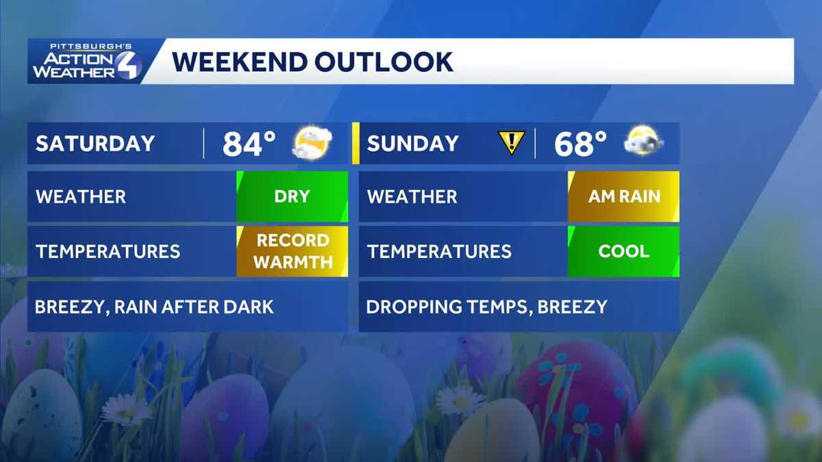
The first weekend of April includes wild temperature swings, sunshine, rain and isolated storm chances. While most of the weekend will be dry, we are tracking rain and storm chances starting this evening through sunrise on Sunday. Easter is an Impact Day for falling temperatures too.Record warmth possible This morning’s showers will fizzle by 8 or 9 a.m. Sunshine will break through and help to build a summer-like feeling. High temperatures will push into the lower 80s this afternoon. Pittsburgh has the potential to break a long-standing record of 83° from 1882.All of this warmth will stir up storms to our west late this afternoon. Activity will show up closer to sunset for areas north of Allegheny County.Impact Day: Overnight rain, falling temperatures on EasterRain will take over area-wide closer to midnight. The thunderstorm potential should subside by then, but heavy rain is still possible. The rain will quickly move through western Pennsylvania – arriving around midnight and exit before 8 a.m. This front will also slash temperatures. Our high for the day will come around midnight. Readings will already drop close to 50 degrees in time for sunrise services. Temperatures will hold in the 50s as a breeze develops through the afternoon.Warming trend down the line next weekThe cooler air hangs around for the first day of next week. High temperatures back peddle into 50s for highs and lows in the 40s. A quick system will produce spotty showers Monday afternoon. Outside of that, there will be plenty of sunshine to go around next week. A warming trend begins on Wednesday.TODAY: Showers before sunrise. Clouds and sun, breezy and summer-like. High: 84°.TONIGHT – Impact Day: Evening shower north. Rain and leftover thunder after midnight. Temperatures fall to 48° by sunrise.TOMORROW – Impact Day: Early morning rain, mostly cloudy and breezy. Temperatures hold steady in the low to mid 50s.MONDAY: Cool with spotty afternoon showers. High: 54°, low: 33°.TUESDAY: Brisk with mostly sunny skies. High: 47°, low: 28°.
PITTSBURGH —
The first weekend of April includes wild temperature swings, sunshine, rain and isolated storm chances. While most of the weekend will be dry, we are tracking rain and storm chances starting this evening through sunrise on Sunday. Easter is an Impact Day for falling temperatures too.
Record warmth possible
This morning’s showers will fizzle by 8 or 9 a.m. Sunshine will break through and help to build a summer-like feeling. High temperatures will push into the lower 80s this afternoon. Pittsburgh has the potential to break a long-standing record of 83° from 1882.
All of this warmth will stir up storms to our west late this afternoon. Activity will show up closer to sunset for areas north of Allegheny County.
Impact Day: Overnight rain, falling temperatures on Easter
Rain will take over area-wide closer to midnight. The thunderstorm potential should subside by then, but heavy rain is still possible. The rain will quickly move through western Pennsylvania – arriving around midnight and exit before 8 a.m.
This front will also slash temperatures. Our high for the day will come around midnight. Readings will already drop close to 50 degrees in time for sunrise services. Temperatures will hold in the 50s as a breeze develops through the afternoon.
Warming trend down the line next week
The cooler air hangs around for the first day of next week. High temperatures back peddle into 50s for highs and lows in the 40s. A quick system will produce spotty showers Monday afternoon. Outside of that, there will be plenty of sunshine to go around next week. A warming trend begins on Wednesday.
TODAY: Showers before sunrise. Clouds and sun, breezy and summer-like. High: 84°.
TONIGHT – Impact Day: Evening shower north. Rain and leftover thunder after midnight. Temperatures fall to 48° by sunrise.
TOMORROW – Impact Day: Early morning rain, mostly cloudy and breezy. Temperatures hold steady in the low to mid 50s.
MONDAY: Cool with spotty afternoon showers. High: 54°, low: 33°.
TUESDAY: Brisk with mostly sunny skies. High: 47°, low: 28°.