
Impact Day: Drying out, cool and breezy Easter for western PA
Temperatures hover in the 40s and 50s this afternoon.
PITTSBURGH’S ACTION SPORTS. ALL RIGHT THANK YOU ASHLEY. TIME NOW FOR ANOTHER LOOK AT WEATHER. AND JILL IT SOUNDS LIKE YESTERDAY WAS JUST SO NICE. AND THEN TODAY IT JUST, YOU KNOW, TAKES A TURN. I WISH YOU COULD HAVE CARRIED AT LEAST A LITTLE BIT OF WHAT WE HAD YESTERDAY. IT WAS JUST THE SUNSHINE, BUT THE RAIN IS OUT. THERE CERTAINLY IS SOME GOOD NEWS HERE AS WE’RE WORKING THROUGH YOUR EASTER SUNDAY. BUT STILL AN IMPACT DAY IS THAT COOLER AIR CONTINUES TO RUSH IN. BIT OF A BREEZE FOR US. WILL STILL ONLY MAKE IT FEEL LIKE THE 30S AND 40S FOR THE NEXT SEVERAL HOURS, WE SHOULD SEE SOME PEEKS OF SUNSHINE HELPING TO DRY THE GRASS UP JUST A LITTLE BIT. IF THERE IS AN EASTER EGG HUNT IN YOUR FAMILY’S FUTURE A LITTLE LATER ON TODAY. NOT QUITE DONE WITH THE APRIL SHOWERS. WE’LL SEE ANOTHER BATCH ARRIVING TOMORROW, BUT THEY’RE GOING TO BE ISOLATED IN COVERAGE. THAT’S IT FOR RAIN THIS WEEK AS WE’LL BRING IN MORE SUNSHINE AS TEMPERATURES WARM UP. AS WE LOOK TOWARDS THE END OF THIS UPCOMING WEEK, RAIN IS GONE. STARTING TO SEE A FEW GAPS IN THE CLOUDS, ESPECIALLY AS WE GET CLOSER TO NEW CASTLE. SO SKIES WILL BRIGHTEN JUST A LITTLE BIT AS WE GO OVER THE NEXT SEVERAL HOURS. BUT IT’S ONLY 43 RIGHT NOW. WINDS GUSTING CLOSE TO 20MPH, MAKING IT FEEL LIKE 36 OUT OF PITTSBURGH INTERNATIONAL, A FAR CRY FROM WHAT WE DEALT WITH YESTERDAY AS WE TIED A RECORD OF 83 DEGREES. 54 IS WHERE WE’RE HEADING THROUGH THE AFTERNOON. BREEZY AND COOLER ON THIS EASTER SUNDAY, TO SAY THE LEAST. STILL ON THE COOL SIDE, EVEN GETTING A LITTLE BIT CHILLY THROUGH TUESDAY. BUT THEN TEMPERATURES START TO ACT MORE SPRING LIKE AS WE USHER IN MORE SUNSHINE THROUGH THE SECOND HALF OF THE WEEK. LET’S TALK ABOUT AN HOUR BY HOUR. LOOK AT THE FORECAST AGAIN. RAIN IS NOW GONE. WE’LL SEE A LITTLE BIT MORE SUNSHINE STARTING TO POKE THROUGH AS WE GET CLOSER TO 11:00 NOON TIME, BUT STILL MORE CLOUDS THAN ANYTHING AS WE GO THROUGH YOUR EASTER LATER ON TONIGHT, MOSTLY CLOUDY. THAT CHILL SETTLES IN WITH TEMPERATURES BACKING OFF INTO THE 30S. COATS ARE GOING TO COME IN HANDY ALONG WITH THE RAIN GEAR AS WE WORK THROUGH THE AFTERNOON. TOMORROW, QUICK HITTING SYSTEM WILL PRODUCE A FEW RAIN SHOWERS, POSSIBLY EVEN A FEW WET SNOWFLAKES. FOR THOSE OF YOU NORTH OF I-80. OTHERWISE, TEMPERATURES STILL PARKED IN THE 50S. THAT REINFORCES THAT COOL FEELING INTO TUESDAY. BUT AGAIN, WE STAY DRY AS HIGH PRESSURE NOSES IN FOR THE MIDDLE AND SECOND PART OF THIS UPCOMING WEEK. 54 TODAY. 50S AGAIN TOMORROW. THOSE ISOLATED SHOWERS IN YOUR FOUR DAY FORECAST. TUESDAY IS A CHILLY DAY OF THE WEEK. WE’RE GOING TO STRUGGLE TO WARM DESPITE ALL THAT SUNSHINE. TEMPERATURES ONLY LOW TO MID 40S. A COLD START TO WEDNESDAY. WE’RE IN THE MID 20S SO FROSTY CONDITIONS THERE BUT A NICE RECOVERY 61 WITH TONS OF SUNSHINE AT SPRING WARMING. TREND REALLY KICKS IN ON THURSDAY AS WE’LL CONTINUE TO CLIMB THROUGH THE 70S STRAIGHT THROUGH NEXT WEEKEND. WE GET THAT SUNSHINE TO BOOT TOO. SO FINALLY STRINGING TOGETHER MORE THAN JUST A HANDFUL OF DRY DAYS IN A ROW. LOOKS LIKE WE COULD EXTEND IT THROUGH NEXT WEEKEND, SO REALLY NOT TOO SHABBY TODAY. AS LONG AS YOU’RE DRESSED APPROPRIATELY, MAYBE LAYERIN
Impact Day: Drying out, cool and breezy Easter for western PA
Temperatures hover in the 40s and 50s this afternoon.

Updated: 10:16 AM EDT Apr 5, 2026
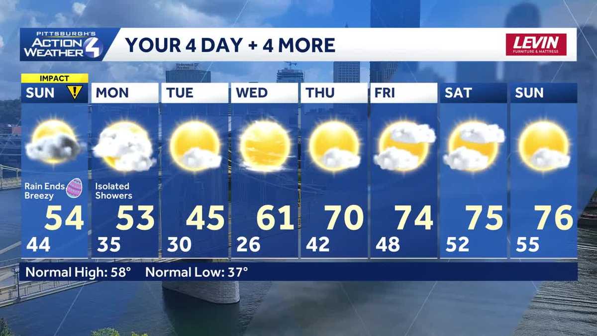
It is an Impact Day for our Easter Sunday with rain coming to an end along with dropping temperatures. The cooler air lingers for a couple more days. A stretch of sunny spring days begins late week.Impact Day: Damp and cooler Easter SundayMuch cooler air is here now that the rain has cleared out. Instead of the summer-like 80s of yesterday, temperatures will once bounce back into the mid 50s this afternoon. A breeze will add to the cooler feeling.Seasonably cool start to the weekThe cooler air isn’t going anywhere. Temperatures will remain in the 50s Monday with isolated showers. A few wet snowflakes could mix in north of Allegheny County Monday morning. A chillier air mass settles over western PA in the wake of this system. Tuesday’s high will struggle to get out of the 40s despite sunshine.Warming up with sunshinePlenty of sunshine is in the work for the middle of the week. High pressure will help to warm us up too. High temperatures return to the 60s on Wednesday and will continue to trend into the 70s through next weekend.TODAY – Impact Day: A few sunny breaks, breezy and cooler. Temperatures drop through late morning; low and mid 50s this afternoon.TONIGHT: Mostly cloudy and chilly. Low: 35°.MONDAY: Cloudy with isolated showers. High: 53°, low: 30°.TUESDAY: Brisk with sunny skies. High: 45°, low: 26°.WEDNESDAY: Cold start, pleasant finish with mostly sunny skies. High: 61°, low: 42°.
PITTSBURGH —
It is an Impact Day for our Easter Sunday with rain coming to an end along with dropping temperatures. The cooler air lingers for a couple more days. A stretch of sunny spring days begins late week.
Impact Day: Damp and cooler Easter Sunday
Much cooler air is here now that the rain has cleared out. Instead of the summer-like 80s of yesterday, temperatures will once bounce back into the mid 50s this afternoon. A breeze will add to the cooler feeling.

Hearst OwnedHearst
The rain ends as temperatures take a downhill turn this afternoon.
Seasonably cool start to the week
The cooler air isn’t going anywhere. Temperatures will remain in the 50s Monday with isolated showers. A few wet snowflakes could mix in north of Allegheny County Monday morning.

Hearst OwnedHearst
We may have to dodge spotty rain showers Monday afternoon.
A chillier air mass settles over western PA in the wake of this system. Tuesday’s high will struggle to get out of the 40s despite sunshine.
Warming up with sunshine
Plenty of sunshine is in the work for the middle of the week. High pressure will help to warm us up too. High temperatures return to the 60s on Wednesday and will continue to trend into the 70s through next weekend.

Hearst OwnedHearst
More sunny days are in our future with the return of spring temperatures later in the week.
TODAY – Impact Day: A few sunny breaks, breezy and cooler. Temperatures drop through late morning; low and mid 50s this afternoon.
TONIGHT: Mostly cloudy and chilly. Low: 35°.
MONDAY: Cloudy with isolated showers. High: 53°, low: 30°.
TUESDAY: Brisk with sunny skies. High: 45°, low: 26°.
WEDNESDAY: Cold start, pleasant finish with mostly sunny skies. High: 61°, low: 42°.