
Mainly clear & chilly overnight; dry to start the week before rain arrives midweek for south-central Pennsylvania
We start the week dry, cool & pleasant, then rain chances arrive in the middle of the work week. We have the latest 10-day forecast in the video.
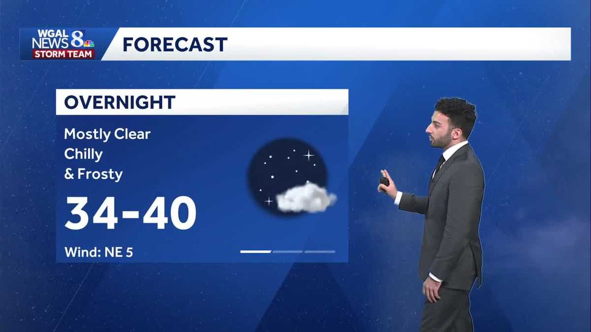
FAMILY 2 TO 3 DAYS. POTENTIALLY DEVASTATING WINDS ARE ALSO EXPECTED IN JAMAICA ON MONDAY NIGHT AND TUESDAY MORNING. SO, RYAN, WILL WE BE SEEING ANY EFFECTS OF MELISSA HERE ON THE EAST COAST? YEAH, NO. SO WE’RE NOT EXPECTING ANY DIRECT IMPACTS FROM HURRICANE MELISSA FOR THE MAINLAND OF THE UNITED STATES. I’LL SHOW YOU THE CURRENT TRACK RIGHT NOW FOR MELISSA. BUT LIKE YOU’RE MENTIONING, WE WERE GOING THROUGH THAT PACKAGE AND IT’S IT’S IT’S GUT WRENCHING TO KNOW THAT THIS STORM IS NOT DONE INTENSIFYING YET. THIS IS STILL HAS YET TO INTENSIFY TO A CATEGORY FIVE HURRICANE. WE DO HAVE A HURRICANE WARNING IN EFFECT SO FAR FOR THE ISLAND OF JAMAICA. ALSO, EASTERN PORTIONS OF CUBA AND ALSO FOR HAITI AS WELL. AT THIS TIME, STILL TRACKING MELISSA. IT’S STILL A CATEGORY FOUR HURRICANE, BUT NOT THAT FAR OFF FROM THE SOUTHERN BEACHES OF JAMAICA. AND HERE’S THE TIMING RIGHT NOW. IT WILL BE A CATEGORY FIVE WHERE IT’S ANTICIPATED TO BE A CATEGORY FIVE HURRICANE. BY THE TIME WE MAKE IT TO MONDAY AFTERNOON, CLOSER TO 1:00. AND IT’S STILL GOING TO BE SUSTAINING ITS STRENGTH GOING THROUGH THE ISLAND OF JAMAICA AND STILL ONLY REALLY ONLY DOWNGRADED TO A CATEGORY FOUR HURRICANE BY THE TIME IT MAKES IT PAST THE ISLAND. NOW, IT IS STILL EXPECTED TO BE A MAJOR HURRICANE, EVEN MAKING ITS WAY IN ON APPROACH TOWARDS TOWARDS THE TURKS AND CAICOS ISLANDS, EVEN EASTERN CUBA. BUT AS YOU CAN SEE, THE TRACK RIGHT NOW FOR MELISSA IS TO GO OUT TO SEA AND AWAY FROM THE MAINLAND OF THE UNITED STATES. NOW, I WILL SAY THERE’S PROBABLY GOING TO BE SOME RIP CURRENT ACTIVITY THAT’S GOING TO BE HAPPENING ALONG THE BEACHES. SO BUT IN TERMS OF ANY DIRECT IMPACTS, THAT IS NOT MAKING ITS WAY TO THE UNITED STATES NOW LOCALLY, BACK HOME, WE ARE LOOKING FORWARD TO A PLEASANT AND DRY START TO THE WORKWEEK WITH WITH SEASONABLY COOL CONDITIONS. BUT CHANCES FOR RAIN DO GO BACK ON OR GO. THEY’RE INCREASING AS WE GET INTO THE MIDDLE OF THE WORKWEEK, WHICH IS GOOD NEWS. WE DEFINITELY NEED THE SHOWERS, FOLKS, BUT WE ARE LOOKING AT ANOTHER UNSETTLED PATTERN AS WE GET INTO NEXT WEEKEND. HERSHEY. RIGHT NOW YOU CAN SEE MAINLY CLEAR CONDITIONS. YOU CAN SEE HERSHEY PARK IN THE BACKGROUND LIGHTING UP THE NIGHT SKY. TONIGHT, MOSTLY CLEAR IS WHERE WE’RE AT 42 DEGREES AS OUR TEMPERATURES FOR CHOCOLATE TOWN. SO THE FORECAST FOR THE REST OF TONIGHT EXPECT MAINLY CLEAR CONDITIONS WITH CHILLY AND FROSTY CONDITIONS OVERNIGHT 34 TO 40 DEGREES FOR TOMORROW MORNING. IT’S A FROSTY START, CALM WINDS, BUT WE’LL BE MOSTLY SUNNY 42 TO 48 DEGREES FOR YOUR MONDAY MORNING, THEN BRIGHT SUNSHINE AND A PLEASANT FALL LIKE DAY AS WE GET INTO TOMORROW AFTERNOON. WITH LIGHT WINDS OUT OF THE NORTHEAST BETWEEN 5 AND 10MPH. NOW I WILL SAY WE HAVE FORECASTED TONIGHT’S LOWS GETTING INTO THE LOWER TO MID 30S FOR SOME AREAS, UPPER 30S FOR HARRISBURG. BUT NOTICE THERE IS NO FROST ADVISORY IN EFFECT. THAT IS BECAUSE THE LAST FOUR COUNTIES YORK, DAUPHIN, LEBANON AND LANCASTER COUNTIES HAVE NOW ENDED THEIR GROWING SEASON BECAUSE OF OBSERVED TEMPERATURES. GETTING INTO THAT FROSTY RANGE NOW ALMANAC FOR THE DAY TODAY WE MADE IT TO 61 DEGREES AT HARRISBURG INTERNATIONAL. THAT’S ON PAR FOR THIS TIME OF YEAR. BUT YOU CAN SEE WE’RE STILL A LITTLE BIT BELOW AVERAGE IN TERMS OF OVERNIGHT LOW TEMPERATURES. WE’RE EXPECTING RIGHT AROUND THAT LOW 40S MARK. YOU CAN SEE TEMPERATURES RIGHT NOW INTO THE 40S 39 FOR LEWISTOWN STORM TEAM LIVE RADAR NETWORK. ALL IS QUIET RIGHT NOW THANKS TO HIGH PRESSURE. BUT I WANT TO SHOW YOU THE SURFACE ANALYSIS HERE. WE DO HAVE A BIT OF A STORM SYSTEM TO OUR SOUTHEAST OR TOWARDS OUR SOUTH. I SHOULD SAY. THAT’S GOING TO THAT’S GOING TO SCOOCH BY TO OUR SOUTH. BUT OUR STORM SYSTEM THAT’S GOING TO BE MOVING IN FOR THE MIDDLE OF THE WORKWEEK, THAT IS STILL OUT TOWARDS THAT’S STILL OVER TOWARDS THE NORTHERN PORTIONS OF THE COUNTRY RIGHT NOW. SO WE’LL BE WATCHING THAT AS WE GET INTO THE WORKWEEK. STILL GOING TO BE MAINLY CLEAR. HIGH PRESSURE IS WINNING OUT, GIVING US NICE AND PLEASANT CONDITIONS FOR THE START OF THE WORKWEEK. YOU CAN SEE PREDICTOR HIGHLIGHTING THAT NOT REALLY GOING TO BE SEEING ANY CLOUDS AT ALL. STAYS TO OUR SOUTH. AND THAT’S GOING TO BE ALLOWING FOR A NICE A DRY START TO THE WORKWEEK. BUT WE DO SEE THOSE SHOWERS COMING IN FOR WEDNESDAY, THURSDAY AND EARLY PORTIONS OF FRIDAY. HALLOWEEN F
Mainly clear & chilly overnight; dry to start the week before rain arrives midweek for south-central Pennsylvania
We start the week dry, cool & pleasant, then rain chances arrive in the middle of the work week. We have the latest 10-day forecast in the video.

Updated: 11:12 PM EDT Oct 26, 2025
Tonight, skies are mostly clear and it’ll be chilly again. There may be frosty areas too. Lows will drop into the mid and upper 30s. Even with frost being a possibility again overnight, the growing season has now officially ended for south-central Pennsylvania, so frost & freeze headlines will no longer be issued until the start of the next growing season in April & May 2026. Temperatures will bottom out in the upper 30s with winds remaining light & variable.A pleasant, fall day kicks off the last week of October. Plenty of sunshine for Monday, with highs near 60 degrees. Tuesday, more clouds drift in from a system to our south so skies will be partly sunny. It is a bit cooler in the mid 50s.Clouds will increase Wednesday with showers holding off until evening. Rain picks up overnight and continues throughout Thursday. It will be breezy and noticeably cooler in the low 50s. Rain amounts of 0.75″ up to 1.80″ is possible and will help the deficit for the month.Some showers may linger early Friday. Thankfully, it looks dry for trick-or-treaters on Halloween evening. You may need a jacket though. It will be brisk with breezy winds and cool temperatures.More unsettled weather is expected for the first week of November.Have a great rest of your night!~ Ryan
Tonight, skies are mostly clear and it’ll be chilly again. There may be frosty areas too. Lows will drop into the mid and upper 30s. Even with frost being a possibility again overnight, the growing season has now officially ended for south-central Pennsylvania, so frost & freeze headlines will no longer be issued until the start of the next growing season in April & May 2026. Temperatures will bottom out in the upper 30s with winds remaining light & variable.
A pleasant, fall day kicks off the last week of October. Plenty of sunshine for Monday, with highs near 60 degrees. Tuesday, more clouds drift in from a system to our south so skies will be partly sunny. It is a bit cooler in the mid 50s.
Clouds will increase Wednesday with showers holding off until evening. Rain picks up overnight and continues throughout Thursday. It will be breezy and noticeably cooler in the low 50s. Rain amounts of 0.75″ up to 1.80″ is possible and will help the deficit for the month.
Some showers may linger early Friday. Thankfully, it looks dry for trick-or-treaters on Halloween evening. You may need a jacket though. It will be brisk with breezy winds and cool temperatures.
More unsettled weather is expected for the first week of November.
Have a great rest of your night!
~ Ryan