
Pittsburgh: Warming up with shower chances this week
No washouts are expected, but showers will impact your Monday morning commute.
EVERYBODY. I’M ANDREW STOCKEY AND THAT’S PITTSBURGH’S ACTION SPORTS. AND IT WILL BE EASY TO HAVE A GREAT SPORTS SUNDAY WITH THIS GREAT WEATHER WE’RE HAVING FOR ALL THE GOLF FANS MIGHT BE A BIG CHALLENGE. DO WE GO OUTSIDE? DO WE KEEP AN EYE ON THE TOURNAMENT LATER TODAY? BUT STILL PLENTY OF TIME BEFORE THINGS GET UNDERWAY LATER ON TO ENJOY THIS GREAT SUNDAY HERE ACROSS WESTERN PENNSYLVANIA. IT IS GOING TO BE WARMER THAN YESTERDAY BY ABOUT 20 DEGREES IN MOST NEIGHBORHOODS. MANY OF US INCHING CLOSE TO 8080 TODAY IN UNIONTOWN, 81, WASHINGTON 79 FOR PITTSBURGH, ALSO UPPER 70 IN BEAVER, 76. AS WE CHECK INTO BUTLER A LITTLE LATER ON TODAY, FOR THE MOST PART, THINGS ARE GOING TO BE MUCH WARMER THAN WE EXPECT FOR THIS TIME OF THE YEAR, FOR THE WEEK AHEAD. ALSO ALONG FOR THE RIDE WILL BE SOME SHOWERS. THAT INCLUDES AS EARLY AS TOMORROW MORNING. I’VE ADDED A BRIEF IMPACT DAY AS WE WILL BE DEALING WITH SOME LIGHT RAIN FOR A FEW HOURS SETTING AROUND THE MONDAY MORNING COMMUTE. NO RAIN IN SIGHT TODAY THOUGH, AS WE BREAK DOWN THE NEXT 12 HOURS, TEMPERATURES QUICKLY WARMING ALREADY GETTING OUR WAY CLOSER TO 50 DEGREES AT THIS HOUR WILL BE AROUND 70 BY LUNCHTIME, MID TO UPPER 70S FOR EVERYONE THIS AFTERNOON. ALREADY STARTING TO SEE A FEW MORE CLOUDS DEVELOPING ACROSS THE REGION. WITH MORE DECORATION THAN ANYTHING, AT LEAST DURING THE DAYLIGHT HOURS TODAY. THEN WE GET TO OUR IMPACT DAY TOMORROW. SHOWERS WILL BE AROUND AS YOU’RE HEADING OUT THE DOOR THROUGH THE MORNING COMMUTE. SO AGAIN, THAT’S THE REASON FOR THE IMPACT DAY. IT’S GOING TO BE LIGHT RAIN. NOT A BIG DEAL, BUT MORE THE TIMING. THAT’S NOT THE BEST. AS WE GEAR FOR THE START OF THE NEW WEEK, AS THE RAIN CLEARS OUT, WE’LL ALSO BE DEALING WITH SOME BREEZY CONDITIONS. WINDS COULD BE GUSTING AROUND 25MPH TOMORROW. THEN WE ENTER OUR STRETCH OF UNSEASONABLY WARM SUMMER LIKE DAYS. HIGHS LOW TO MID 80S THROUGH WEDNESDAY. SO LET’S TALK ABOUT TODAY AGAIN. YOU CAN SEE THOSE CLOUDS DRIFTING IN AS WE GO THROUGH LATE MORNING INTO THE AFTERNOON. BUT STILL A DELIGHT EVEN AS WE GO THROUGH THE EVENING HOURS. MORE CLOUDS BUILD AFTER MIDNIGHT WITH A QUICK LITTLE PULSE OF ENERGY THAT WILL SEND A FEW SHOWERS OUR WAY AS EARLY AS 6 A.M., BUT THE MAIN EVENT, I THINK, GETS HERE WITH A LINE AROUND 9:00 IN THE MORNING. SO UMBRELLAS GO UP AGAIN. GENERALLY SOME LIGHT RAIN. IT’S THROUGH IN A MATTER OF HOURS, REALLY BY ABOUT 11:00 NOON, EVERYBODY IS DRYING OUT. WE STAY QUIET THROUGH THE AFTERNOON AS WE’LL INTRODUCE A FEW MORE BREAKS FOR SUNSHINE AS WE GEAR UP FOR THE BRAND NEW WEEK. TUESDAY’S A BIT OF A DIFFERENT STORY, A FEW MORE ISOLATED SHOWERS, EVEN A THUNDERSTORM OR TWO COULD POP AS A STALLED BOUNDARY. WILL TRY AND SEND SOME ENERGY IN OUR DIRECTION. THAT WOULD ALSO BE THE CASE ON WEDNESDAY, BUT A BETTER CHANCE TO SURGE WELL INTO THE 80S. IN FACT, WE COULD CHALLENGE A RECORD HIGH TEMPERATURE THERE 84 WOULD BE ONE OFF THE RECORD FROM 1883. STILL, THE 80S ON THURSDAY, MORE THAN LIKELY THE LAST OF OUR UNSETTLED DAYS. AGAIN, WE’LL CONTINUE TO DODGE SHOWERS AND THUNDERSTORMS. THAT COULD BE AN ALL DAY THING THROUGH THURSDAY. FRIDAY LOOKS QUIETER, MUCH COOLER, BUT STILL UPPER 70S QUITE A BIT WARMER FOR THIS TIME OF THE YEAR. WE’LL WATCH ANOTHER FRONT THAT ONE LOOKS TO MOVE THROUGH PRETTY QUICKLY. BY THE TIME WE GET TOWARDS NEXT WEEKEND, SO ANOTHER SHOT OF RAIN COULD BE COMING OUR WAY. BUT I’M NOT COMPLAINING. I’M HAPPY WITH TH
Pittsburgh: Warming up with shower chances this week
No washouts are expected, but showers will impact your Monday morning commute.

Updated: 10:05 AM EDT Apr 12, 2026
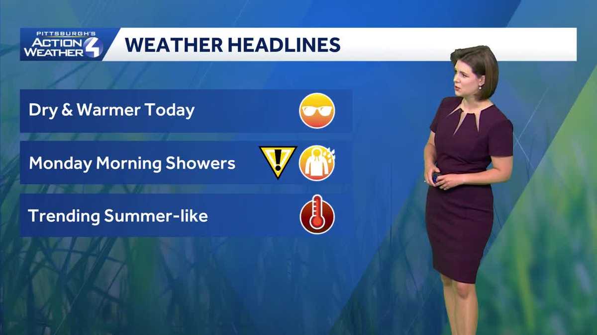
This week’s warming temperatures also bring rain chances. High temperatures will feel more summer-like. Rain chances will be sporadic. The first batch arrives in time for the Monday morning commute, prompting an Impact Day. Finishing the weekend on a warmer noteThe summer-like feels begin today with highs in the upper 70s. As temperatures warm, we will watch the sky trend partly to mostly cloudy. Conditions will remain dry all day long.A string of 80-degree days begins on Tuesday. Wednesday still has the potential to challenge a record in Pittsburgh. The above-average temperatures will extend through the start of next week.Impact Day: Morning commute showersThe first shower chance of the new week has sped up. Showers now look to arrive by 6 a.m. Monday and continue through the morning commute. While the rain will light, it is still an Impact Day for the light rain while you’re trying to get out the door.The second half of the day will include only pop-up showers, primarily north of Allegheny County. It will be breezy with highs in the mid 70s.More warmth, more showersThe timing and coverage of showers later in the week is a little tricky. It will all depend on our proximity to a stalled boundary to our north. Isolated to scattered showers are still possible Wednesday and Thursday. We are also watching a more potent front for next weekend.TODAY: Becoming partly cloudy. Warmer, high: 79°.TONIGHT: Mostly cloudy and mild. Low: 60°.MONDAY – Impact Day: Showers before 10 a.m. Breezy. High: 76°, low: 62°.TUESDAY: Warm with late-day shower or storm. High: 80°, low: 64°.WEDNESDAY: Near-record warmth with isolated showers. High: 84°, low: 62°.
PITTSBURGH —
This week’s warming temperatures also bring rain chances. High temperatures will feel more summer-like. Rain chances will be sporadic. The first batch arrives in time for the Monday morning commute, prompting an Impact Day.
Finishing the weekend on a warmer note
The summer-like feels begin today with highs in the upper 70s. As temperatures warm, we will watch the sky trend partly to mostly cloudy. Conditions will remain dry all day long.

Hearst OwnedHearst
A much warmer to end the weekend with more of summer-like feeling.
A string of 80-degree days begins on Tuesday. Wednesday still has the potential to challenge a record in Pittsburgh. The above-average temperatures will extend through the start of next week.
Impact Day: Morning commute showers
The first shower chance of the new week has sped up. Showers now look to arrive by 6 a.m. Monday and continue through the morning commute. While the rain will light, it is still an Impact Day for the light rain while you’re trying to get out the door.

Hearst OwnedHearst
A swift line of showers will impact the Monday morning commute.
The second half of the day will include only pop-up showers, primarily north of Allegheny County. It will be breezy with highs in the mid 70s.
More warmth, more showers
The timing and coverage of showers later in the week is a little tricky. It will all depend on our proximity to a stalled boundary to our north. Isolated to scattered showers are still possible Wednesday and Thursday. We are also watching a more potent front for next weekend.

Hearst OwnedHearst
We will continue to dodge raindrops through Thursday. A better chance for rain is possible next weekend.
TODAY: Becoming partly cloudy. Warmer, high: 79°.
TONIGHT: Mostly cloudy and mild. Low: 60°.
MONDAY – Impact Day: Showers before 10 a.m. Breezy. High: 76°, low: 62°.
TUESDAY: Warm with late-day shower or storm. High: 80°, low: 64°.
WEDNESDAY: Near-record warmth with isolated showers. High: 84°, low: 62°.