
Temperatures soar to the 80s this week across south-central Pennsylvania
Winds shifting to the southwest will pump in summerlike warmth this up coming week. Temperatures will challenge record highs and a few morning warmest low records.
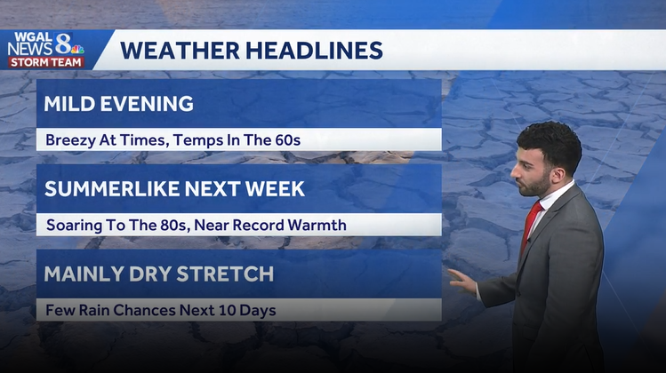
PARTICIPATING RESTAURANTS ON OUR WEBSITE AT WGAL.COM. AND RYAN, IF YOU’RE HEADING OUT TO LANCASTER RESTAURANT WEEK, IT SEEMS LIKE IT’S A GOOD DAY TO WALK TO THE RESTAURANT, SIT OUTSIDE, RIGHT? YEAH, TEMPERATURES ARE GOING TO BE GETTING INTO THE 70S AND INTO THE 80S, TOO. AS WE GET INTO THE MIDDLE OF THE WEEK. WE COULD BE SEEING SOME NEAR RECORD WARMTH BY THE TIME WE GET TO OUR WEDNESDAY. BUT LEBANON SKY CAM AT THIS TIME HAD A FAIRLY NICE DAY. NOW WE’RE STARTING TO SEE SOME HIGH CLOUDS BEGIN TO MOVE IN, AND TEMPERATURES ARE SITTING RIGHT AROUND THE MID 60S AT THIS TIME, WITH A STIFF SOUTHERLY BREEZE. I WOULD SAY BETWEEN 10 AND 15MPH FOR MOST OF THE AREA. BUT WE’RE SEEING GENERALLY MOSTLY SUNNY SKIES ACROSS THE AREA, AND IT’S STILL GOING TO BE REMAINING MILD WITH BREEZY CONDITIONS AT TIMES. TEMPERATURES WILL CONTINUE TO LOWER THROUGH THE 60S. AND THEN FOR THIS COMING WEEK, NEXT WEEK, SOARING TO THE 80S NEAR RECORD WARMTH. BY THE TIME WE GET TO OUR WEDNESDAY AND THEN THERE’S ONLY A FEW RAIN CHANCES OVER THE NEXT SEVERAL DAYS, IT’S GOING TO BE A MAINLY DRY STRETCH FOR THE SUSQUEHANNA VALLEY, SO BUT WE’LL BE WILL BE ENJOYING SOME SUNSHINE WITH A FEW. AGAIN, A FEW CHANCES OF SOME SHOWERS, BUT THEY’RE LOOKING MORE MINIMAL RIGHT NOW. TEMPERATURES TODAY HIT RIGHT AROUND 66 DEGREES AT HARRISBURG INTERNATIONAL AIRPORT 63 IS WHAT WE EXPECT FOR THIS TIME OF YEAR. NO RAIN WAS RECORDED AT HARRISBURG INTERNATIONAL AIRPORT. SO FOR THE FORECAST FOR THE REST OF THIS EVENING, EXPECT INCREASING CLOUDS STILL MILD IN THE LOWER 60S AND BREEZY. WE’LL HAVE THOSE WINDS OUT OF THE SOUTH SOUTHEAST BETWEEN 10 AND 15MPH, THEN STILL BREEZY OVERNIGHT. COOLER DOWN INTO THE LOWER 50S, BUT WE’LL SEE MOSTLY CLOUDY CONDITIONS FOR THE FOR THE OVERNIGHT PERIOD. AND THEN WE’RE LOOKING AT A FEW AFTERNOON AND EVENING SHOWERS FOR TOMORROW. TEMPERATURES GETTING INTO THE UPPER 70S. BUT RESTAURANT WEEK, IT’S GOING TO BE IT’S GOING TO BE NICE THOUGH. TEMPERATURES INTO THE UPPER 70S A FEW AFTERNOON SHOWERS. I WOULDN’T CALL THE DAY A COMPLETE WASHOUT. FEELING LIKE JUNE FOR YOUR. TUESDAY 84 DEGREES AND THEN 86 NEAR RECORD WARMTH FOR OUR WEDNESDAY NOW. LATEST PRECIPITATION TOTALS WERE STILL BELOW AVERAGE FOR THE MONTH TO DATE, BUT IN TERMS OF SEASON TO DATE, WE’RE. WE’RE RIGHT AROUND PAR FOR THIS TIME OF THE YEAR. SO ONLY ABOUT 17 HUNDREDTHS OF AN INCH ABOVE WHAT WE EXPECT. BUT THAT’S RIGHT AROUND PAR. BUT POLLEN LEVELS FOR TOMORROW, HIGH FOR TREES AND GRASS MOLD LEVELS ARE LOW. AIR QUALITY WILL BE MODERATE IN A UV INDEX, 35 MINUTE BURN TIME. SO WE RATED THAT AS MODERATE FOR THE AFTERNOON AND THE TEMPERATURES STILL INTO THE 60S, BUT WE’RE INTO THE 70S FOR GETTYSBURG, CHAMBERSBURG AND LEWISTOWN AT THIS TIME WINDS OUT OF THE SOUTH. I’D SAY BETWEEN TO SEE THIS BETWEEN 15, ALMOST 20MPH IN SOME AREAS. STORM TEAM, LIVE RADAR NETWORK, NOT SEEING ANY SHOWERS, JUST REALLY THE SATELLITE IMAGERY SHOWING SOME OF THE UPPER LEVEL CLOUDS THAT ARE MOVING THROUGH. BUT WE STILL HAVE HIGH PRESSURE THAT’S HELPING TO KEEP OUR SKIES CLEAR BEFORE THIS WARM FRONT STARTS TO MOVE THROUGH AND CONTINUES TO INCREASE OUR CLOUD COVER AND BECOME MOSTLY CLOUDY FOR THE MAJORITY OF THE DAY MONDAY. BUT NOW HERE COMES THIS BOUNDARY THAT’S GOING TO START TO SHIFT THROUGH EARLY AFTERNOON FOR MONDAY. THAT’S GOING TO BRING THAT CHANCE OF SHOWERS INTO THE AREA. GIVE US A FEW OF THOSE SHOWERS. THEN WE’LL START TO CLEAR. BY THE TIME WE GET TO OVERNIGHT MONDAY INTO TUESDAY. NOW WE ARE WATCHING A CHANCE OF SOME SHOWERS FOR EARLY IN THE DAY. TUESDAY I WOULD SAY MID TO LATE MORNING, A STRAY SHOWER CHANCE AND ALSO WITH A SERIES OF FRONTS NEARBY AND ALSO WITH THAT AVAILABLE HEAT, WE MAY SEE A CHANCE OF A STORM OR TWO FOR LATE TUESDAY, SOMETHING WE’RE GOING TO CONTINUE TO KEEP AN EYE ON FOR TUESDAY. BUT CERTAINLY THE STORY FOR THE WEEK IS THAT IT’S GOING TO BE FEELING LIKE JUNE, FEELING VERY MUCH LIKE SUMMER. YOU CAN SEE TEMPERATURES GETTING INTO THE MID 80S. WE COULD POTENTIALLY BE RIGHT NEAR THAT RECORD MARK. THE RECORD IS 87 DEGREES. BACK IN 1941 FOR WEDNESDAY, SOMETHING THAT WE’RE GOING TO CONTINUE TO WATCH AS WE HEAD INTO THE WEEK. LOOKING AHEAD INTO THE END OF THE WEEK, NOT AS WARM, STI
Temperatures soar to the 80s this week across south-central Pennsylvania
Winds shifting to the southwest will pump in summerlike warmth this up coming week. Temperatures will challenge record highs and a few morning warmest low records.

Updated: 6:38 PM EDT Apr 12, 2026
After a sunny & mild day, cloud cover is beginning to increase across the area and temperatures will start to lower through the low 60s this evening. Tonight, expect mostly cloudy skies as a warm front moves through the area overnight. Lows will bottom out in the lower 50s. It will remain breezy through the night.Monday highs jump into the mid to upper 70s. Southwesterly winds bring in more cloud cover, and a few afternoon showers can’t be ruled out, so it’s worth keeping an eye to the sky if you’re outside. Rainfall amounts expected around 0.10” northwest of Harrisburg, with less than 0.05” elsewhere.We flip the switch to early summer with highs soaring into the mid 80s Tuesday through Thursday. We will challenge records on Wednesday. Forecast is 86 and the record is 87 set in 1941. Morning lows will be warmer than afternoon average highs Thursday. You’ll notice an uptick in humidity with dew points near 60°. Not oppressive by any means, but enough to make it feel a bit sticky, especially in the afternoons. Other than a late shower or thunderstorm Tuesday and a couple late showers Thursday night, rain chances remain low so great weather for outdoor plans.Temperatures briefly fall back to near 80° on Friday. It’s still warm and pleasant. That tranquil weather continues into the start of the weekend with summerlike weather continuing. Highs are in the low 80s. The next cold front comes in on Sunday with the chance for showers. This system is a game changer and will bring temperatures back to the 60s by Monday.Have a good rest of your Sunday!~ Ryan
After a sunny & mild day, cloud cover is beginning to increase across the area and temperatures will start to lower through the low 60s this evening.
Tonight, expect mostly cloudy skies as a warm front moves through the area overnight. Lows will bottom out in the lower 50s. It will remain breezy through the night.
Monday highs jump into the mid to upper 70s. Southwesterly winds bring in more cloud cover, and a few afternoon showers can’t be ruled out, so it’s worth keeping an eye to the sky if you’re outside. Rainfall amounts expected around 0.10” northwest of Harrisburg, with less than 0.05” elsewhere.
We flip the switch to early summer with highs soaring into the mid 80s Tuesday through Thursday. We will challenge records on Wednesday. Forecast is 86 and the record is 87 set in 1941. Morning lows will be warmer than afternoon average highs Thursday. You’ll notice an uptick in humidity with dew points near 60°. Not oppressive by any means, but enough to make it feel a bit sticky, especially in the afternoons. Other than a late shower or thunderstorm Tuesday and a couple late showers Thursday night, rain chances remain low so great weather for outdoor plans.
Temperatures briefly fall back to near 80° on Friday. It’s still warm and pleasant. That tranquil weather continues into the start of the weekend with summerlike weather continuing. Highs are in the low 80s. The next cold front comes in on Sunday with the chance for showers. This system is a game changer and will bring temperatures back to the 60s by Monday.
Have a good rest of your Sunday!
~ Ryan