
Temperatures soar to the 80s this week across south-central Pennsylvania
Winds shifting to the southwest will pump in summerlike warmth this up coming week. Temperatures will challenge record highs and a few morning warmest low records.
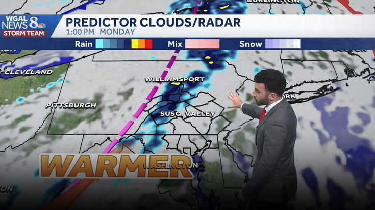
WEBSITE. JUST HEAD OVER TO WGAL.COM. AND RYAN. IT SEEMS LIKE IT’S GOING TO BE A NICE WEEK TO SIT OUTSIDE. IF YOU’RE HEADING OUT TO RESTAURANT WEEK. YEAH, ABSOLUTELY. IT’S GOING TO BE IT’S GOING TO BE VERY WARM. AS WE HEAD INTO THE WORKWEEK. WE’RE GOING TO SEE WE’RE GOING TO SEE TEMPERATURES GETTING UP INTO THE 80S AS WE HEAD INTO THE MIDDLE OF THE WORKWEEK. COULD POTENTIALLY GET SOME RECORD CHALLENGING WARMTH FOR OUR WEDNESDAY. SO LET’S TALK ABOUT IT. SO IT’S GOING TO FEEL LIKE SUMMER AS WE HEAD INTO THE WEEK WITH HIGHS INTO THE 80S TUESDAY THROUGH THURSDAY, WEDNESDAY, THOUGH, THAT’S THAT’S WHAT I’M GOING TO BE WATCHING TO SEE WHERE THOSE TEMPERATURES ARE GOING TO BE GOING. WE’RE FORECASTING 87 OR EXCUSE ME, 86. BUT THE RECORD IS 87. BACK IN 1941. A FEW RAIN CHANCES THOUGH FOR THE NEXT SEVERAL DAYS. BUT SHOWER CHANCES DO RETURN AS WE HEAD INTO NEXT WEEKEND. SO ALMANAC FOR THE DAY TODAY HIT A HIGH OF 66 DEGREES. AVERAGE FOR THIS TIME OF YEAR IS 63. NO RAINFALL AT HARRISBURG INTERNATIONAL AIRPORT. BUT HERE’S THE WEATHER PLANNER FOR THE REST OF THE NIGHT. TONIGHT, EXPECT MOSTLY CLOUDY CONDITIONS, MOSTLY CLOUDY CONDITIONS TO DEVELOP AT AROUND 52 DEGREES IS WHERE WILL BOTTOM OUT AT. AND THEN FOR TOMORROW MORNING. MOSTLY CLOUDY, BREEZY, 64 DEGREES. AND ONCE WE GET INTO THE AFTERNOON, WE’LL HAVE A BOUNDARY START TO MOVE THROUGH. THAT’S GOING TO ALLOW FOR FEW SHOWER CHANCES FOR THE AFTERNOON. STILL REMAINING MOSTLY CLOUDY FOR THE ENTIRE AREA. SO WEATHER IN HEALTH FOR THE DAY TOMORROW. TREE POLLEN LEVELS. THEY’RE GOING TO BE HIGH REMAINING HIGH AND GRASS POLLEN LEVELS THERE A LITTLE BIT MORE ON THE MODERATE SIDE BUT CLOSE TO THE TO THE HIGH SIDE. MOLD LEVELS WILL BE LOW AIR QUALITY IS MODERATE. WE’LL HAVE A MODERATE UV INDEX, ABOUT A 35 MINUTE BURN TIME FOR THE AFTERNOON. NOW TEMPERATURES INTO THE 40S FOR LANCASTER INTO THE UPPER 50S FOR THE WHITE ROSE CITY 57 IN GETTYSBURG, 59 IN CARLISLE. STILL INTO THE 60S FOR CHAMBERSBURG AND LEWISTOWN AT THIS TIME. WINDS THOUGH COMING IN OUT OF THE SOUTH, I’D SAY GENERALLY BETWEEN 5 AND 15MPH. STILL A LITTLE BIT BREEZY AS WE GO THROUGH THE REST OF THIS. AS WE GO THROUGH THE REST OF THE NIGHT TONIGHT INTO TOMORROW, YOU CAN SEE STORM TEAM LIVE RADAR NETWORK. NOT REALLY, JUST NOT SEEING ANY PRECIPITATION, JUST REALLY SEEING SOME CLOUDS BEGINNING TO MOVE THROUGH. AND THAT’S JUST AHEAD OF A WARM FRONT THAT’S GOING TO START TO MOVE INTO THE SUSQUEHANNA VALLEY OVERNIGHT TONIGHT, GETTING INTO TOMORROW MORNING. NOW THIS IS WHERE THE WARMER AIR IS REALLY GOING TO START TO MOVE IN. ONCE THIS FRONT PASSES BY, WE’LL HAVE THAT. WE’LL HAVE THAT AIR USHER IN. AND HERE COMES THIS BOUNDARY THAT’S GOING TO START TO PUSH THROUGH OUR WESTERN COMMUNITIES. THAT’S GOING TO BE RIGHT AROUND 1230, 1:00 IN THE AFTERNOON. I DO EXPECT TO SEE A FEW SHOWERS BEGIN TO DEVELOP AND THEN LAST UP UNTIL FOR A COUPLE OR FEW HOURS, BY THE TIME WE GET TO ABOUT 6:00 IN THE EVENING, THAT’S WHEN WE’LL SEE THAT BOUNDARY PUSH OUT AND WE’LL START TO SEE SOME CLEARING IN THE WAKE OF THAT BOUNDARY. NOW HERE COMES TUESDAY MORNING THAT WE’RE SEEING SOME CLEARING. BUT ONCE WE GET INTO THE AFTERNOON AND POTENTIALLY THE EVENING, WE ARE LOOKING AT THE CHANCE OF SEEING SOME MORE SHOWERS AND COULD POTENTIALLY SEE SOME STORMS AS WE GET INTO LATE TUESDAY. SO I DO HAVE A THUNDERSTORM CHANCE ON TAP FOR US AS WE GET INTO OUR TUESDAY. BUT THE MAIN STORY HERE, LOOK AT THIS. WE GOT TEMPERATURES GETTING INTO THE 80S FOR TUESDAY, WEDNESDAY AND ALSO OUR THURSDAY. THIS IS THE DAY I’M GOING TO BE WATCHING. WEDNESDAY WE’RE FORECASTING 86. THE RECORD IS 87, WHICH WAS SET BACK IN 1941. SO SOMETHING TO KEEP AN EYE ON AS WE HEAD INTO THE NEXT SEVERAL DAYS. SO FEW SHOWER CHANCES FOR OUR MONDAY. STILL FEELING LIKE WE’RE FEELING LIKE JUNE FOR OUR TUESDAY. STILL HAVE THAT SHOWER ICON THERE NEAR RECORD WARMTH WEDNESDAY SUMMER LIKE FOR YOUR THURSDAY. NOT AS WARM AS WE HEAD INTO FRIDAY AND SATURDAY. I THINK THE NEXT BEST CHANCE OF
Temperatures soar to the 80s this week across south-central Pennsylvania
Winds shifting to the southwest will pump in summerlike warmth this up coming week. Temperatures will challenge record highs and a few morning warmest low records.

Updated: 11:01 PM EDT Apr 12, 2026
Tonight, expect mostly cloudy skies as a warm front moves through the area overnight. Lows will bottom out in the lower 50s. It will remain breezy through the night.Monday highs jump into the mid to upper 70s. Southwesterly winds bring in more cloud cover, and a few afternoon showers can’t be ruled out, so it’s worth keeping an eye to the sky if you’re outside. Rainfall amounts expected around 0.10” northwest of Harrisburg, with less than 0.05” elsewhere.We flip the switch to early summer with highs soaring into the mid 80s Tuesday through Thursday. We will challenge records on Wednesday. Forecast is 86 and the record is 87 set in 1941. Morning lows will be warmer than afternoon average highs Thursday. You’ll notice an uptick in humidity with dew points near 60°. Not oppressive by any means, but enough to make it feel a bit sticky, especially in the afternoons. Other than a late shower or thunderstorm Tuesday and a couple late showers Thursday night, rain chances remain low so great weather for outdoor plans.Temperatures briefly fall back to near 80° on Friday. It’s still warm and pleasant. That tranquil weather continues into the start of the weekend with summerlike weather continuing. Highs are in the low 80s. The next cold front comes in on Sunday with the chance for showers. This system is a game changer and will bring temperatures back to the 60s by Monday.Have a good rest of your night!~ Ryan
Tonight, expect mostly cloudy skies as a warm front moves through the area overnight. Lows will bottom out in the lower 50s. It will remain breezy through the night.
Monday highs jump into the mid to upper 70s. Southwesterly winds bring in more cloud cover, and a few afternoon showers can’t be ruled out, so it’s worth keeping an eye to the sky if you’re outside. Rainfall amounts expected around 0.10” northwest of Harrisburg, with less than 0.05” elsewhere.
We flip the switch to early summer with highs soaring into the mid 80s Tuesday through Thursday. We will challenge records on Wednesday. Forecast is 86 and the record is 87 set in 1941. Morning lows will be warmer than afternoon average highs Thursday. You’ll notice an uptick in humidity with dew points near 60°. Not oppressive by any means, but enough to make it feel a bit sticky, especially in the afternoons. Other than a late shower or thunderstorm Tuesday and a couple late showers Thursday night, rain chances remain low so great weather for outdoor plans.
Temperatures briefly fall back to near 80° on Friday. It’s still warm and pleasant. That tranquil weather continues into the start of the weekend with summerlike weather continuing. Highs are in the low 80s. The next cold front comes in on Sunday with the chance for showers. This system is a game changer and will bring temperatures back to the 60s by Monday.
Have a good rest of your night!
~ Ryan