
Five-day stretch of 80-degree weather ahead in south-central Pennsylvania
NOW, THE WGAL NEWS EIGHT STORM TEAM FORECAST WITH CHIEF METEOROLOGIST CHRISTINE FERREIRA. GOOD MORNING. IT IS 522. LET’S TAKE A LOOK AT THE PREDICTOR. RIGHT NOW IT’S DRY, BUT BY ABOUT 9:00 WE’LL SEE A FEW SHOWERS KNOCKING ON OUR DOORSTEP IN NORTHWESTERN COUNTIES. NOTICE THEY MOVE FROM NORTHWEST TO SOUTHEAST. THIS IS AT 10 A.M. STILL SEEING SOME SHOWERS THROUGH FRANKLIN COUNTY TOWARD MIFFLIN COUNTY, JUNIATA AND PERRY COUNTIES. AND THEN RIGHT AT 11:00, THE SHOWERS COME THROUGH HARRISBURG, LEBANON, AND GETTYSBURG, AND THEN IN SOUTHEASTERN COUNTIES SHORTLY THEREAFTER, RIGHT AROUND LUNCHTIME. SO WE SHOULD JUST BE SEEING A LITTLE BIT OF LIGHT RAIN TODAY. THEN WE’RE DONE WITH IT. AND THE SKY CLEARS TOWARD EVENING. TODAY, OUR NEWS EIGHT STORM TEAM FORECAST CALLS FOR CLOUDS THIS MORNING. FEW SHOWERS DEVELOPING IN NORTHWESTERN COUNTIES FOR THE AFTERNOON. STILL MOSTLY CLOUDY WITH SHOWERS EXITING SOUTHEAST. IT WILL BE BREEZY. IT WILL BE WARMER AND THEN THE SKY CLEARS AS WE HEAD TOWARD EVENING AND TEMPERATURES WILL BE IN THE 70S FOR HIGHS TODAY. FOR TONIGHT, WE’RE DOWN TO ABOUT 60 DEGREES. PARTLY CLOUDY KEEPING IT MILD. THE AVERAGE LOWS SHOULD BE IN THE LOW 40S AT THIS TIME OF THE YEAR. TOMORROW WE’LL SEE PARTLY SUNNY SKIES. IT’S THE START OF OUR TOASTY STRETCH WHERE WE GET INTO THE 80S. SO SUMMERLIKE WARMTH THIS WEEK ALL THE WAY THROUGH SATURDAY. IT’S GOING TO BE IN THE 80S STARTING TOMORROW, SO WE DO HAVE A WARM SOUTHWESTERLY BREEZE TOMORROW. A COUPLE OF SHOWERS OR THUNDERSTORMS IN THE AFTERNOON AND EVENING. TEMPERATURE CHECK. IT’S 54 IN SELINSGROVE. WE HAVE 49 IN LANCASTER, 52 FOR CARLISLE, 54 IN YORK. WIND SPEEDS FAIRLY LIGHT THIS MORNING, BUT THEY’LL BE PICKING UP AT ABOUT 10 TO 20MPH OUT OF THE SOUTH SOUTHWEST. WEATHER AND HEALTH UPDATE. YOU KNOW THAT TREE POLLEN IS HIGH. OUR AIR QUALITY IS MODERATE, AND TODAY’S UV INDEX IS LOW WITH A BURN TIME OF OVER ONE HOUR. DUE TO THE CLOUDS AROUND. RIGHT NOW THERE’S A WARM FRONT TRYING TO LIFT INTO PENNSYLVANIA. SO THAT FRONT IS GOING TO BE RESPONSIBLE FOR A LINE OF SHOWERS THAT COMES THROUGH HERE LATER THIS MORNING. WE TIME IT OUT FOR YOU AGAIN. REMEMBER IT’S ABOUT 9:00 UNTIL ABOUT 2:00 IN THE AFTERNOON WHERE WE COULD SEE THOSE SHOWERS MOVING THROUGH. TONIGHT WE ARE DRY AND CLEAR. AND THEN FOR TOMORROW WE’LL SEE SOME SUN TO START. THEN PARTLY SUNNY SKIES, A COUPLE OF SHOWERS. THUNDERSTORMS ARE POSSIBLE IN THE AFTERNOON. AND THEN THIS DECAYING LINE COMES THROUGH IN THE EVENING. SO WE’LL KEEP AN EYE ON THOSE FOR YOU. BUT RIGHT NOW WE’RE NOT OUTLOOK FOR ANY SEVERE WEATHER. AS WE GET INTO WEDNESDAY. THERE’S A SERIES OF FRONTS MOVING BY TO OUR NORTH. THAT’S WHERE THE FOCUS OF THE RAIN WILL BE. BUT OUR FOCUS ON WEDNESDAY IS GOING TO BE NEAR RECORD WARMTH. THE RECORD STANDS AT 87. WE’RE FORECASTING 86. I THINK WE COULD DO IT IN SOME PARTS OF THE SUSQUEHANNA VALLEY FOR SURE. SO HERE’S A LOOK AT OUR PREDICTOR ESTIMATED RAINFALL TOTALS FROM ANYTHING THAT YOU SEE TODAY OR TOMORROW. AND THESE NUMBERS SHOULD BOUNCE AROUND DEPENDING ON THE THUNDERSTORM CHANCES TOMORROW. BUT RIGHT NOW IT’S LOOKING LIKE A FEW TENTHS OF AN INCH FOR US. MAX. HERE’S A LOOK AT THE TEN DAY FORECAST. WE HAVE 86 ON WEDNESDAY AND THURSDAY, BUT THE RECORD THURSDAY IS 89 FOR FRIDAY. WE ARE AT 80 DEGREES SATURDAY STILL IN THE 80S. BUT THEN ALL OF A SUDDEN SPRING SHOWS UP ON SUNDAY. SHOWERS, SOME RAIN, AND THAT’S GOING TO KNOCK OUR HIGHS RIGHT BACK DOWN TO THE 60S, WHERE THEY SHOULD BE AT THIS TIME OF THE YEAR.
Five-day stretch of 80-degree weather ahead in south-central Pennsylvania

Updated: 7:24 AM EDT Apr 13, 2026
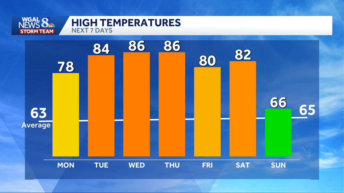
A summer-like stretch will bring five straight days of 80-degree weather in south-central Pennsylvania. The above-average warmth begins Tuesday and lasts through Saturday, before cooler spring air returns Sunday. What to expect Five consecutive days of 80-degree high temperatures. Near-record warmth possible Tuesday through Thursday. Periodic chance for showers and thunderstorms. Noticeably cooler air arrives on Sunday, with highs near 66 degrees. Tuesday: Warm, summerlike conditions begin. High near 84 degrees. The daily record is 89 degrees, set in 1941. Few afternoon and evening showers or thunderstorms are possible. Wednesday: High near 86 degrees. Could come close to the daily record of 87 degrees, set in 1941. Dew points around 60 degrees may make it feel more humid. Thursday: Highs in the mid-to-upper 80s. A slight chance of a late-day shower or thunderstorm. The daily record is 89 degrees, set in 2002. Friday: Highs in the low 80s. Warm conditions continue. Saturday: Highs in the low 80s. Marks the final day of the 80-degree stretch. Did you capture a moment that you would like to share with News 8? Send us your photos or videos at https://www.wgal.com/upload.
A summer-like stretch will bring five straight days of 80-degree weather in south-central Pennsylvania.
The above-average warmth begins Tuesday and lasts through Saturday, before cooler spring air returns Sunday.
What to expect Five consecutive days of 80-degree high temperatures. Near-record warmth possible Tuesday through Thursday. Periodic chance for showers and thunderstorms. Noticeably cooler air arrives on Sunday, with highs near 66 degrees.

Tuesday:
Warm, summerlike conditions begin. High near 84 degrees. The daily record is 89 degrees, set in 1941. Few afternoon and evening showers or thunderstorms are possible.
Wednesday: High near 86 degrees. Could come close to the daily record of 87 degrees, set in 1941. Dew points around 60 degrees may make it feel more humid. Thursday: Highs in the mid-to-upper 80s. A slight chance of a late-day shower or thunderstorm. The daily record is 89 degrees, set in 2002. Friday: Highs in the low 80s. Warm conditions continue. Saturday: Highs in the low 80s. Marks the final day of the 80-degree stretch.

Did you capture a moment that you would like to share with News 8? Send us your photos or videos at https://www.wgal.com/upload.