
The day begins with passing showers. Most of the activity will clear western Pennsylvania by 9 a.m. This is the first batch of a daily dose of showers through late week. Tuesday is now an Impact Day for the potential for a late-day thunderstorms. Summer-like temperatures are assisting the unsettled set-up.Morning showers, breezy afternoonA quick round of spotty showers will cross the Pittsburgh area ahead of the morning rush. Most of the showers will be east by 9 a.m.The rest of the day will be partly cloudy and breezy. Wind gusts up to 30 mph are expected. High temperatures will reach the mid to upper 70s again.Impact Day Tuesday: Late-day stormsIsolated showers will be around throughout the day tomorrow. We will monitor a wave of rain and embedded storms that will drop southward by late afternoon or the evening. Some of these storms will be capable of producing downpours and strong winds. Areas to the north of Pittsburgh will be at the highest risk. Activity will fizzle as it sink into southwestern PA.A week of summer-like temperaturesOutside of the daily showers chance, we are also tracking a surge of unseasonable warmth. A string of 80-degree days will begin tomorrow. There is still a chance of tying a record high on Wednesday.TODAY: Passing morning shower, partly cloudy and breezy afternoon. High: 76°.TONIGHT: Mostly cloudy with isolated showers. Low: 62°.TUESDAY – Impact Day: Spotty showers with late-day storms north. Warmer. High: 80°, low: 65°.WEDNESDAY: Near-record warmth with isolated showers, especially north. High: 84°, low: 64°.THURSDAY: A few more showers possible. High: 82°, low: 58°.
PITTSBURGH —
The day begins with passing showers. Most of the activity will clear western Pennsylvania by 9 a.m. This is the first batch of a daily dose of showers through late week. Tuesday is now an Impact Day for the potential for a late-day thunderstorms. Summer-like temperatures are assisting the unsettled set-up.
Morning showers, breezy afternoon
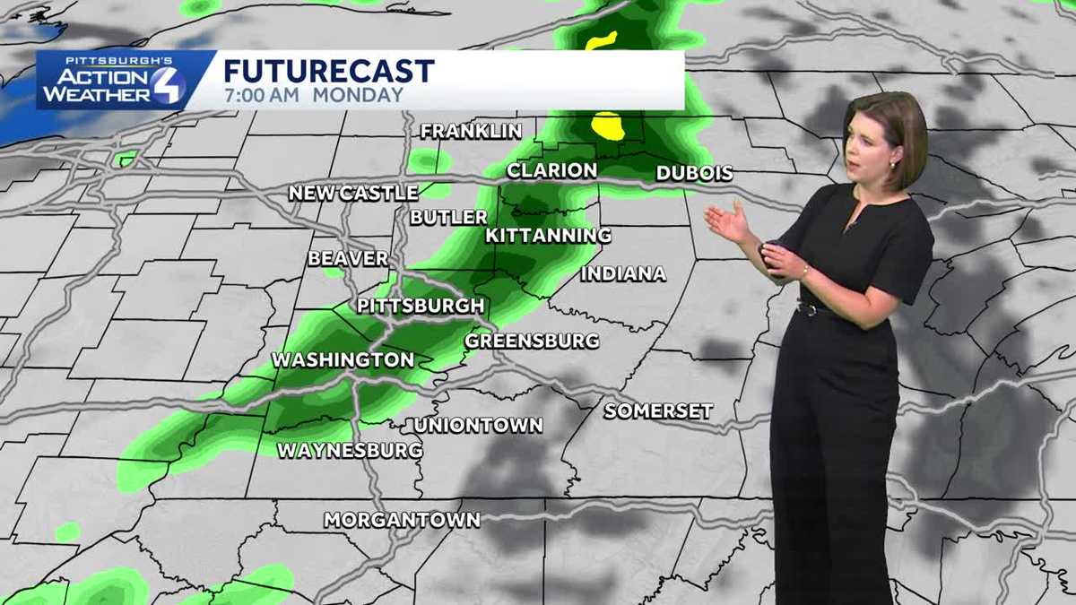
A quick round of spotty showers will cross the Pittsburgh area ahead of the morning rush. Most of the showers will be east by 9 a.m.

Hearst OwnedHearst
Light showers will swipe the Pittsburgh area before 9 a.m.; breezy and warm this afternoon.
The rest of the day will be partly cloudy and breezy. Wind gusts up to 30 mph are expected. High temperatures will reach the mid to upper 70s again.
Impact Day Tuesday: Late-day storms

Hearst OwnedHearst
Spotty showers to start Tuesday. There will be a break through the afternoon with highs near 80°.
Isolated showers will be around throughout the day tomorrow. We will monitor a wave of rain and embedded storms that will drop southward by late afternoon or the evening. Some of these storms will be capable of producing downpours and strong winds. Areas to the north of Pittsburgh will be at the highest risk. Activity will fizzle as it sink into southwestern PA.

Hearst OwnedHearst
A part of Tuesday’s Impact Day includes isolated stronger storms north of Pittsburgh during the evening.
A week of summer-like temperatures
Outside of the daily showers chance, we are also tracking a surge of unseasonable warmth. A string of 80-degree days will begin tomorrow. There is still a chance of tying a record high on Wednesday.

Hearst OwnedHearst
The unseasonable warmth continues through the start of the weekend. Rain chances will eventually set temperatures back.
TODAY: Passing morning shower, partly cloudy and breezy afternoon. High: 76°.
TONIGHT: Mostly cloudy with isolated showers. Low: 62°.
TUESDAY – Impact Day: Spotty showers with late-day storms north. Warmer. High: 80°, low: 65°.
WEDNESDAY: Near-record warmth with isolated showers, especially north. High: 84°, low: 64°.
THURSDAY: A few more showers possible. High: 82°, low: 58°.