
Temperatures will surge to the 80s, putting records in jeopardy for south-central Pennsylvania
Southwest winds will pump in summerlike warmth starting tomorrow lasting into the upcoming weekend. Temperatures will challenge record highs and a few morning warmest low records.
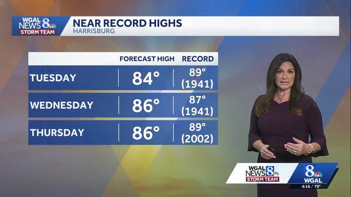
TEAM FORECAST, WITH METEOROLOGIST MARYELLEN PANN. GOOD AFTERNOON. TEMPERATURES ARE WARMING QUICKLY THIS AFTERNOON ALREADY 10 TO 15 DEGREES WARMER THAN YESTERDAY’S TEMPERATURES. IT’S GOING TO BE A MILD AND BREEZY EVENING. OTHER THAN A SPRINKLE OR STRAY SHOWER. WE’LL CONTINUE TO SEE THE CLOUDS DECREASING AND WE COULD SEE GUSTS UP TO 25MPH, BUT THEY WILL BE MUCH LIGHTER AS WE HEAD INTO THE OVERNIGHT PERIOD. SUMMERLIKE WARMTH HEADS OUR WAY. IF YOU’RE A FAN OF 80 DEGREE TEMPERATURES, WELL, YOU’RE GOING TO ENJOY THE NEXT SEVERAL DAYS. IN FACT, WE COULD COME CLOSE TO RECORD HIGHS AND RECORD WARMEST LOWS WILL ALSO BE IN JEOPARDY. AND IT LOOKS LIKE THIS WARM AIR WILL STAY WITH US UNTIL WE GET INTO THE WEEKEND. IT WILL BE COOLER BY SUNDAY AS A POTENT SYSTEM COMES THROUGH. THAT’S GOING TO BE OUR BEST CHANCE FOR SEEING WIDESPREAD SHOWERS AS A FRONT BRINGS TEMPERATURES BACK DOWN TO THE 60S. SO HERE’S A LOOK AT SOME OF THOSE RECORD HIGHS TOMORROW. THE TEMPERATURE WE’RE FORECASTING IS 84. I THINK THE RECORD WILL BE OKAY. IT’S 89 SET IN 1941. BUT AS WE HEAD INTO WEDNESDAY AND THURSDAY, THOSE RECORDS WILL BE IN JEOPARDY. WEDNESDAY ESPECIALLY THE RECORD IS 87 SET IN 1941. OUR FORECAST IS 86. ON THURSDAY, WE’RE FORECASTING 86 IN THE RECORD IS 89 SET BACK IN 2002. ANOTHER RECORD TO TELL YOU WE HAVEN’T HAD FIVE DAYS OF 80 DEGREE WEATHER IN APRIL SINCE 2002. SO WE’LL IT WILL BE INTERESTING TO SEE IF WE GET. THAT’S A LONG STANDING RECORD. TEMPERATURES. RIGHT NOW IT IS WARM OUTSIDE. WE HAVE 81 IN LEBANON, 81 OR 78 IN DUNCANNON, 81 IN CARLISLE AND CAMP HILL. WE HAVE 70 UPPER 70S YOU CAN SEE TO THE SOUTHWEST AND 77 IN NEW YORK. AS I ZOOM OUT, WE’RE GOING TO BE ON THE SOUTH SIDE OF A SERIES OF FRONTAL BOUNDARIES TO OUR NORTH. SO THAT MEANS WE’RE GOING TO BE ON THE WARM SIDE, WINDS COMING IN FROM THE SOUTHWEST, AND YOU CAN SEE TEMPERATURES OFF TO THE WEST IN THE MID 80S. SO AS THE COLD FRONT GETS CLOSER AND CLOSER THE NEXT SEVERAL DAYS, OUR TEMPERATURES ARE JUST GOING TO GET EVEN WARMER WINDS RIGHT NOW, ANYWHERE FROM 10 TO 20MPH COMING IN FROM THE SOUTHWEST, WEST, SOUTHWEST. AND THAT’S HELPING TO BRING IN THE MILDER AIR. WE’RE STILL IN THE 70S AT 8:00 CLEARING SKIES. IT IS GOING TO BE A PLEASANT EVENING OVERNIGHT TONIGHT PARTLY CLOUDY, TEMPERATURE DOWN TO 60 DEGREES. THE WARMEST RECORD, WARMEST RECORD LOW IS 62. SO WE’RE GOING TO COME CLOSE TO THAT TONIGHT. AND THEN TOMORROW WE ARE LOOKING AT PARTLY SUNNY SKIES, A FEW SHOWERS IN THE AFTERNOON EVENING, MAYBE EVEN A RUMBLE OF THUNDER, BUT PLENTY OF DRY HOURS. TEMPERATURES ARE GOING TO BE WARM AROUND 84 DEGREES IN YOUR WEATHER AND HEALTH CHECK FOR TOMORROW. POLLEN LEVELS CONTINUE TO RUN HIGH, MAINLY TREES AND GRASS. MOLD IS LOW, AIR QUALITY IS MODERATE. AND CHECK OUT THAT UV INDEX. CERTAINLY WANT TO MAKE SURE YOU HAVE THAT SUNSCREEN ON BECAUSE WE’LL HAVE A BURN TIME OF 25 MINUTES. UV INDEX WILL BE ON THE HIGH SIDE. SO AS I MENTIONED, A STRAY SHOWER HERE IN THE NEXT HOUR OR SO. OTHERWISE WE CONTINUE TO SEE THE CLOUDS DECREASING AS WE GO THROUGH THE EVENING. YOU CAN SEE THE FRONTAL BOUNDARIES TO OUR NORTH. AND AS WE TAKE A LOOK AT PREDICTOR, THE FRONTS WILL STAY TO OUR NORTH. BUT WHAT WILL HAPPEN IS THEY’LL BE CLUSTERS OF STORMS ALONG THIS FRONT, AND SOME OF THOSE STORMS COULD HOLD TOGETHER. THEY’LL BE WEAKENING, BUT MAY CLIP US WITH ISOLATED SHOWER OR TWO TOMORROW. RUMBLE THUNDER AS THEY MAKE THEIR WAY THROUGH THE AREA, BUT PLENTY OF DRY HOURS. WE’RE DRY ON WEDNESDAY. WE STILL HAVE THAT SOUTHWESTERLY FLOW THERE. YOU CAN SEE THE SHOWERS AND STORMS, AND THE CHANCES FOR SHOWERS AND STORMS WILL BE HIGHEST WELL TO OUR NORTH, BUT WE’LL KEEP A CLOSE EYE ON THAT EVENTUALLY. THE COLD FRONT OUT WEST WILL MAKE ITS WAY THROUGH THE AREA. LOOKS LIKE ON THURSDAY YOU CAN SEE TEMPERATURES IN THE MID 80S. WE GET THAT FRONT TO COME IN OR A LITTLE WEAK DISTURBANCE TO COME IN AND KNOCKS TEMPERATURES BACK TO 80. AND THEN WE GET BACK INTO THE LOW 80S. BUT IT’S SUNDAY SYSTEM THAT’S MUCH STRONGER. THAT WILL BRING US A BETTER CHANCE FOR SHOWERS AND TEMPERATURES IN THE 60S. SO HERE’S YOUR TEN DAY FORECAST. YOU CAN SEE 80 FOR THE NEXT FIVE DAYS. OVERNIGHT LOWS IN THE 60S. AND THEN WE HEAD TO THE MID 60S FOR HIGHS ON SUNDAY.
Temperatures will surge to the 80s, putting records in jeopardy for south-central Pennsylvania
Southwest winds will pump in summerlike warmth starting tomorrow lasting into the upcoming weekend. Temperatures will challenge record highs and a few morning warmest low records.

Updated: 4:27 PM EDT Apr 13, 2026
This evening clouds will partially clear, and temperatures remain warm in the 70s. Overnight, expect partly cloudy skies with lows around 60°. We flip the switch to early summer with highs soaring into the 80s Tuesday through Thursday. Tuesday highs climb to the low 80s with partly sunny skies. Wednesday we will challenge the record high. The forecast is 86 and the record is 87 set in 1941. We’ll challenge another high on Thursday. The forecast is 86 and the record is 89, set in 2002. A few mornings will start warmer than the usual afternoon high in the low 60s, potentially challenging record warmest lows. You’ll notice an uptick in humidity with dew points near 60° to make it feel a bit sticky, especially in the afternoons. Other than a late shower or thunderstorm Tuesday and a couple late showers Thursday night, rain chances remain low so great weather for outdoor plans. Temperatures briefly fall back to near 80° on Friday. It’s still warm and pleasant. That tranquil weather continues into the start of the weekend with summerlike weather continuing. Highs return to the low 80s. The next potent cold front comes on Sunday with the chance for showers. This system is a game changer and will bring temperatures back to the 60s.
This evening clouds will partially clear, and temperatures remain warm in the 70s. Overnight, expect partly cloudy skies with lows around 60°.
We flip the switch to early summer with highs soaring into the 80s Tuesday through Thursday. Tuesday highs climb to the low 80s with partly sunny skies. Wednesday we will challenge the record high. The forecast is 86 and the record is 87 set in 1941. We’ll challenge another high on Thursday. The forecast is 86 and the record is 89, set in 2002.
A few mornings will start warmer than the usual afternoon high in the low 60s, potentially challenging record warmest lows. You’ll notice an uptick in humidity with dew points near 60° to make it feel a bit sticky, especially in the afternoons. Other than a late shower or thunderstorm Tuesday and a couple late showers Thursday night, rain chances remain low so great weather for outdoor plans.
Temperatures briefly fall back to near 80° on Friday. It’s still warm and pleasant. That tranquil weather continues into the start of the weekend with summerlike weather continuing. Highs return to the low 80s. The next potent cold front comes on Sunday with the chance for showers. This system is a game changer and will bring temperatures back to the 60s.