
Hurricane Melissa Approaches Jamacia; Rain & Wind Return Midweek In South Central Pennsylvania
High temperatures on Monday will reach the upper 50s & low 60s for the Susquehanna Valley.
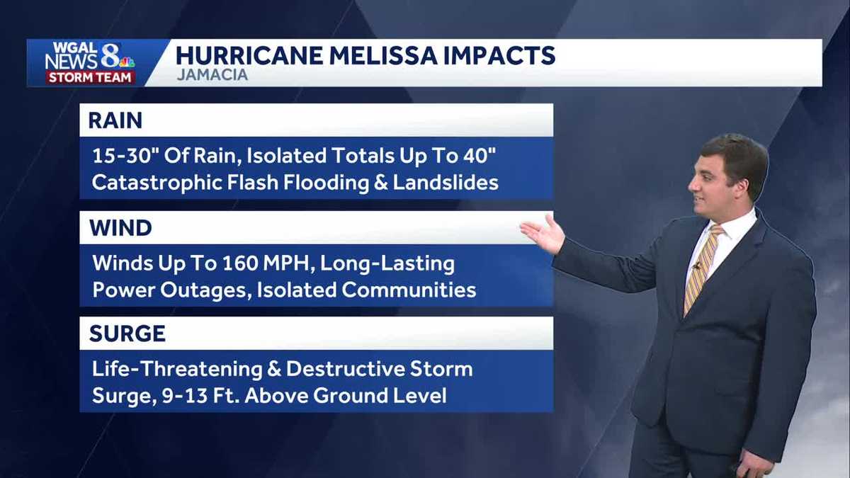
GOOD AFTERNOON. WE CONTINUE TO WATCH HURRICANE MELISSA AGAIN AS A CATEGORY FIVE STORM WITH MAXIMUM SUSTAINED WINDS AROUND 165MPH. IT IS MAKING ITS FINAL APPROACH TO JAMAICA, AND AT THIS POINT, JAMAICA WILL TAKE A DIRECT HIT. THERE IS NO IFS, ANDS OR BUTS AT THIS POINT THAT WILL OCCUR TOMORROW MORNING HERE, RIGHT AROUND 7:00 IN THE MORNING, IS WHEN WE EXPECT LANDFALL TO BE AS IT MAKES ITS WAY OVER THE ISLAND AND TOWARDS CUBA, IT IS EXPECTED TO START TO WEAKEN AS IT CROSSES MOUNTAINOUS TERRAIN AND THEN HEADING TO TURKS AND CAICOS, EVENTUALLY TOWARDS BERMUDA. AS WE HEAD TOWARDS THE END OF THE WEEK. BUT STILL, EVEN BY THE TIME IT GETS TO BERMUDA, STILL A CATEGORY ONE HURRICANE. AND IT’S A SLOW MOVER. IT’S NOT MOVING VERY MUCH AT ALL, AND THAT’S JUST GOING TO ALLOW THINGS TO PILE UP IN TERMS OF RAINFALL, 15 TO 30IN OF RAIN, WIDESPREAD ISOLATED AMOUNTS OVER THREE FEET. KEEP IN MIND HERE IN THE SUSQUEHANNA VALLEY, WE GET ABOUT 30 TO 35IN OF RAIN A YEAR. SO THEY’RE GOING TO BE GETTING OUR YEARLY RAINFALL AND ONE STORM HERE IN JUST A COUPLE OF DAYS. SO FLASH FLOODING AND LANDSLIDES VERY LIKELY WINDS UP TO 160MPH. IT WILL CAUSE LONG LASTING POWER OUTAGES, WEEKS IF NOT MONTHS IN SOME CASES HERE. SO UNFORTUNATELY, A VERY DEVASTATING SITUATION THERE FOR JAMAICA. YOU’RE LOOKING OUTSIDE OUR GETTYSBURG SKYCAM RIGHT NOW. AND HERE IS A LOOK AT TEMPERATURES 56 IN LEBANON. IT’S 54 BACK HERE AT HOME IN LANCASTER, 53 IN HARRISBURG, AS WELL AS CARLISLE AND 58 IN CHAMBERSBURG. BUT STORM TRACK LIVE RADAR NETWORK HERE IS A LOT QUIETER ACROSS THE SUSQUEHANNA VALLEY. PLENTY OF SUNSHINE IF YOU WANT TO GET OUT TODAY. YOU HAVE NO PROBLEMS DOING SO. MAYBE YOU WANT TO GO TO HERSHEY GARDENS. LOOKING AT THE FORECAST FOR TODAY, TEMPERATURE RIGHT AROUND 60 DEGREES. PLENTY OF SUNSHINE THERE. OPEN UNTIL 5:00. HERE TO GO CHECK OUT SOME OF THE MUMS AS THEY’RE IN NOW IN PEAK BLOOM TONIGHT. WE’LL SEE TEMPERATURES DROP BACK TO 3640 DEGREES OVERNIGHT TONIGHT WITH A CLEAR SKY AND CHILLY. IT WILL LEAD TO SOME PATCHY FROST ACROSS THE AREA, BUT WE WILL NOT SEE FROST ADVISORIES BECAUSE THE ENTIRE SUSQUEHANNA VALLEY NOW IS OUT OF THE GROWING SEASON. SO THEY STOP ISSUING THOSE ONCE THE GROWING SEASON HAS ENDED. TOMORROW, MOSTLY SUNNY. YOU’LL SEE THOSE CLOUDS INCREASING IN THE EVENING THOUGH, WITH HIGHS IN THE UPPER 50S. I WANT TO SHOW YOU PREDICTOR HERE. WE HAVE HIGH PRESSURE THAT’S KEEPING THE CLOUD COVER TO OUR SOUTH, BRINGING US ABUNDANT SUNSHINE TODAY. AND FOR THE FIRST PART OF TOMORROW. BUT THEN THOSE CLOUDS BEGIN TO INCH BACK IN AS WE HEAD INTO TOMORROW NIGHT AND WEDNESDAY. WEDNESDAY DOES LOOK DRY FOR MOST OF THE DAY, BUT THEN SOME RAIN BEGINS TO APPROACH THE AREA AS WE HEAD INTO WEDNESDAY NIGHT, AND THAT’S WHEN OUR RAIN CHANCES GO UP. IT WILL BE REALLY THURSDAY MORNING THAT WE HAVE OUR BEST SHOT AT GETTING SOME WIDESPREAD RAIN INTO THE AREA, AND WE DO NEED IT. WE DO HAVE DROUGHT CONDITIONS IN PARTS OF THE AREA, SO WE’LL TAKE IT. TEN DAY FORECAST 60 TODAY. WE’LL DROP BACK TO 38 OVERNIGHT FOR THAT LOW 58 ON YOUR TUESDAY, 56 WITH SHOWERS LATE IN THE EVENING WEDNESDAY HANGING AROUND INTO YOUR THURSDAY, ESPECIALLY IN THE MORNING HOURS AND BREEZY AND COO
Hurricane Melissa Approaches Jamacia; Rain & Wind Return Midweek In South Central Pennsylvania
High temperatures on Monday will reach the upper 50s & low 60s for the Susquehanna Valley.

Updated: 1:10 PM EDT Oct 27, 2025
Good afternoonAs high pressure builds south from Canada, expect plentiful sunshine today, with seasonable highs near 60 degrees.Tonight, lows will fall to the mid-to-upper 30s under clear skies. Since the growing season has officially ended across the Susquehanna Valley, Frost Advisories and Freeze Warnings will no longer be issued.Tuesday will feature mostly sunny skies through midday, then increasing evening clouds. Highs will be slightly cooler, in the upper 50s.Look for mostly cloudy skies on Wednesday, with showers returning late in the evening, as low pressure develops in the Midwest. Highs will hit 56 degrees.Rain continues Wednesday night into Thursday, before tapering to showers Thursday afternoon. Highs will remain in the mid-50s.Isolated showers are possible on Friday, as low pressure lifts into New England. It will be breezy to windy, and it looks mainly dry for trick-or-treaters.Breezy, cool weather follows Saturday under partly sunny skies. Sunday will feature more clouds and a few showers. Weekend temperatures will hover in the upper 50s.Next week, isolated rain chances are in the forecast Monday and Tuesday, along with breezy conditions and below-average highs in the low-to-mid 50s.Have a great day!
Good afternoon
As high pressure builds south from Canada, expect plentiful sunshine today, with seasonable highs near 60 degrees.
Tonight, lows will fall to the mid-to-upper 30s under clear skies. Since the growing season has officially ended across the Susquehanna Valley, Frost Advisories and Freeze Warnings will no longer be issued.
Tuesday will feature mostly sunny skies through midday, then increasing evening clouds. Highs will be slightly cooler, in the upper 50s.
Look for mostly cloudy skies on Wednesday, with showers returning late in the evening, as low pressure develops in the Midwest. Highs will hit 56 degrees.
Rain continues Wednesday night into Thursday, before tapering to showers Thursday afternoon. Highs will remain in the mid-50s.
Isolated showers are possible on Friday, as low pressure lifts into New England. It will be breezy to windy, and it looks mainly dry for trick-or-treaters.
Breezy, cool weather follows Saturday under partly sunny skies. Sunday will feature more clouds and a few showers. Weekend temperatures will hover in the upper 50s.
Next week, isolated rain chances are in the forecast Monday and Tuesday, along with breezy conditions and below-average highs in the low-to-mid 50s.
Have a great day!