
Rain moves in tonight & tomorrow AM, then a brief cool down for south-central Pennsylvania
A cold front moving in later this evening will bring much cooler air for Sunday. Needed rain arrives late tonight, exiting early Sunday. A Freeze Watch is going in effect Monday night through Tuesday morning.
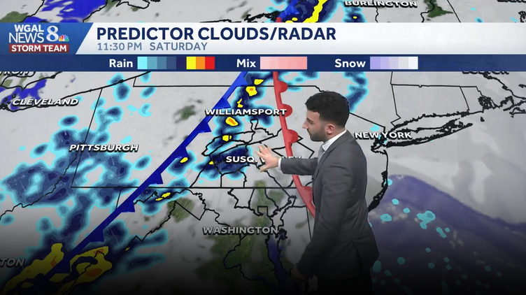
KNOW? TO BE IN THE HOME OF THE ACTUAL REAL PATRIOTS. NOW THE WGAL NEWS EIGHT STORM TEAM FORECAST WITH METEOROLOGIST RYAN ARGENTI. ANOTHER NICE DAY ACROSS THE SUSQUEHANNA VALLEY. HERE’S LEBANON SKY CAM BLUE SKIES, SOME HIGH LEVEL CLOUDS IN THE BACKGROUND THERE. BUT WE ARE GOING TO BE SEEING A CHANGE IN THESE WEATHER CONDITIONS AS WE GET INTO THE NEXT FEW HOURS. HERE WE ARE EXPECTING SOME MORE SHOWERS TO COME THROUGH THE SUSQUEHANNA VALLEY. SO ENJOY THESE TEMPERATURES INTO THE LOWER 70S. WE HAVE A SOUTHEASTERLY TEN MILE PER HOUR BREEZE RIGHT NOW, SO IT’S NOTICEABLE AND IT’S REFRESHING AS WE GET INTO THE WE GET INTO THE REST OF THE EVENING, BUT WIDESPREAD RAIN DOES RETURN. IT DEVELOPS LATE EVENING TO OUR WEST AND THEN EXITS EAST EARLY SUNDAY. AND AS WE HEAD INTO NEXT WEEK, WE ARE LOOKING AT MUCH COOLER AIR COMING IN. WE’LL HAVE TEMPERATURES DIVING INTO THE 50S AND WHAT WE ALSO HAVE ON TAP IS THE POTENTIAL FOR FROST AND FREEZE. WE’RE GOING TO HAVE OVERNIGHT LOW TEMPERATURES GETTING BACK INTO THE 30S. WE ACTUALLY HAVE AN IMPACT NIGHT SET. AND I’LL SHOW YOU THAT HERE IN JUST A FEW MINUTES. INCREASING CLOUDS FOR THIS EVENING. RAIN WILL START TO DEVELOP LATE, BUT THEN WE’LL START TO SEE THOSE SCATTERED SHOWERS BEGIN TO COME THROUGH TONIGHT. IT WILL BE BREEZY, STILL A LITTLE BIT MILD FOR THIS TIME OF THE YEAR, AND IT WILL BE 54 FOR TOMORROW. WE’LL SEE THOSE MORNING SHOWERS. THEN IT WILL TURN PARTLY SUNNY ONCE WE GET INTO THE AFTERNOON. SO LAST COUPLE DAYS LEFT FOR LANCASTER CITY RESTAURANT WEEK. YOU CAN SEE DRY THROUGH THE EVENING FOR THE REST OF OUR SATURDAY. TEMPERATURES STILL INTO THE 70S 54. AS WE HEAD INTO OUR SUNDAY. RAIN ENDS EARLY IN THE MORNING AND FOR THE AFTERNOON IT WILL STILL BE BREEZY AND COOLER. JUST MAKE SURE YOU PACK LIKE AN EXTRA. MAYBE A LIGHT JACKET, POSSIBLY. NOW WEATHER IN HELL FOR THE DAY TOMORROW. VERY HIGH POLLEN LEVELS FROM THE TREES. MOLD LEVELS REMAIN LOW, AIR QUALITY IS GOOD, AND A LOW UV INDEX WILL HAVE ABOUT A 50 MINUTE BURN TIME FOR THE AFTERNOON. AND HERE’S OUR PRECIPITATION CHANCES FOR THE NEXT SEVERAL DAYS. SO THE NEXT BEST CHANCE OF RAIN LIKE WE JUST CHATTED ABOUT IS GOING TO BE OVERNIGHT TONIGHT INTO OUR SUNDAY MORNING. SO HIGHER CHANCE FOR PRECIPITATION. THEN LOOKING IN THE NEXT WEEK. ABOUT A 20% CHANCE OF SOME SHOWERS FOR YOUR WEDNESDAY. BUT HEADING INTO THE WEEKEND THERE ARE SOME. THERE ARE SOME MORE CHANCES FOR SHOWERS WHICH WILL CONTINUE TO FINE TUNE AS WE GET CLOSER TO NEXT WEEKEND. WE SEE TEMPERATURES INTO THE 70S 71 IN LANCASTER, 72 IN HARRISBURG, 77 IN CHAMBERSBURG. AT THIS HOUR, YOU CAN SEE CURRENT WINDS OUT OF THE SOUTHEAST, GENERALLY BETWEEN 10 AND 15MPH, AND YOU CAN START TO SEE SOME OF THOSE WINDS ARE SHIFTING NOW WEST. YOU CAN SEE WHERE THAT FRONT OR SOME OF THE EFFECTS OF THAT WARM FRONT THAT’S GOING TO START TO COME THROUGH. YOU CAN SEE THAT’S GOING TO START TO ALLOW TEMPERATURES TO SHIFT WESTWARD. BUT HERE COMES THAT COLD FRONT THAT’S ALLOWING THIS THESE SHOWER CHANCES TO COME THROUGH THIS EVENING. THEY’LL START TO COME IN CLOSER TO ABOUT EIGHT, 9:00 THIS EVENING. AND YOU CAN SEE THEY’LL REALLY START TO ENTER INTO THE VALLEY ONCE WE GET TO 11, 1130 TONIGHT. COLD FRONT STARTS TO PUSH THROUGH. THAT ALLOWS SOME SCATTERED SHOWER CHANCES OVERNIGHT INTO OUR SUNDAY MORNING. SO YOU CAN SEE FOR ANY SUNDAY MORNING SERVICES THAT YOU HAVE, JUST EXPECT TO SEE SOME SHOWERS FOR THE START OF YOUR SUNDAY. THEN ONCE THAT COLD FRONT MOVES OUT IN THE WAKE OF THAT FRONT, WE’LL START TO SEE SOME CLEARING. BUT IT’S GOING TO BECOME BREEZY AND COOLER AS WE HEAD INTO OUR SUNDAY AFTERNOON. ANOTHER COLD FRONT STARTS TO SWEEP THROUGH. THAT’S GOING TO START TO LOWER OUR TEMPERATURES ONCE AGAIN AND ALLOW THOSE TEMPERATURES TO REALLY START TO START TO DIP DOWN INTO INTO THE 30S, ESPECIALLY AS WE GET INTO OUR MONDAY NIGHT. SO LET’S, LET’S, LET’S CHAT ABOUT THAT ACTUALLY MONDAY NIGHT INTO TUESDAY MORNING. NOTICE THESE TEMPERATURES GETTING DOWN INTO THE 20S, POTENTIALLY UPPER 20S SPECIFICALLY, POSSIBLY FOR FOR HARRISBURG INTO THE LOWER 30S FOR THE MAJORITY OF THE VALLEY. BECAUSE OF THAT THERE, WE DO HAVE AN IMPACT NIGHT SET FOR MONDAY NIGHT INTO TUESDAY MORNING. SO THERE IS A FREEZE WATCH THAT WILL GO INTO EFFECT FROM 12 A.M. TUESDAY TO 9 A.M. TUESDAY. FOR THOSE TEMPERATURES GETTING INTO THE LOWER 30S. SO WHAT THE WHAT PRECAUTIONS YOU SHOULD TAKE? MAKE SURE YOU COVER ANY SENSITIVE PLANTS, ANY ANY PLANTS THAT YOU’VE BEEN GETTING AHEAD ON IN TERMS OF YOUR FLOWER BEDS. MAKE SURE YOU WANT TO COVER THOSE UP OR ANY POTTED PLANTS. YOU’RE GONNA WANT TO MAKE SURE YOU BRING THOSE INSIDE. AS WE HEAD INTO MONDAY NIGHT INTO TUESDAY, BECAUSE IT IS GOING TO BE GETTING COLD AS WE HEAD INTO MONDAY NIGHT. NOW, FOR THE REST OF THE WEEK, WE DO START TO MODERATE BACK TO THE UPPER 60S FOR OUR FOR OUR WEDNESDAY 72 FOR THURSDAY 76 AS WE HEA
Rain moves in tonight & tomorrow AM, then a brief cool down for south-central Pennsylvania
A cold front moving in later this evening will bring much cooler air for Sunday. Needed rain arrives late tonight, exiting early Sunday. A Freeze Watch is going in effect Monday night through Tuesday morning.

Updated: 7:01 PM EDT Apr 18, 2026
Partly sunny skies are on tap for the next couple hours across the area before an advancing cold front brings scattered showers across the area late this evening. Temperatures will begin to lower to the upper 60s later this evening. Showers will develop in western counties & progress eastward tonight.Overnight, scattered showers continue into Sunday morning. Showers should exit western areas by 11 am and eastern areas by 1 pm. Rain totals will range from 0.50″ to 0.75″. Sunday’s highs will be much cooler, in the low to mid 50s. It will turn breezy and chilly Sunday night, as lows fall to the upper 30s.Monday will be the coolest day next week, around 50 degrees, and temperatures will fall to near freezing Monday night. Don’t forget to protect tender plants and vegetation!Tuesday will be milder, with highs near 60 and a light breeze. If you’re looking for warmer temperatures, highs will be a few degrees above average, near 70, Wednesday through Friday, with a chance of showers on Wednesday.Another chance of showers arrives Saturday into Sunday. Highs in the 70s drop to more seasonable temperatures in the mid 60s on Sunday.Have a great rest of your Saturday!~ Ryan
Partly sunny skies are on tap for the next couple hours across the area before an advancing cold front brings scattered showers across the area late this evening. Temperatures will begin to lower to the upper 60s later this evening. Showers will develop in western counties & progress eastward tonight.
Overnight, scattered showers continue into Sunday morning. Showers should exit western areas by 11 am and eastern areas by 1 pm. Rain totals will range from 0.50″ to 0.75″. Sunday’s highs will be much cooler, in the low to mid 50s. It will turn breezy and chilly Sunday night, as lows fall to the upper 30s.
Monday will be the coolest day next week, around 50 degrees, and temperatures will fall to near freezing Monday night. Don’t forget to protect tender plants and vegetation!
Tuesday will be milder, with highs near 60 and a light breeze. If you’re looking for warmer temperatures, highs will be a few degrees above average, near 70, Wednesday through Friday, with a chance of showers on Wednesday.
Another chance of showers arrives Saturday into Sunday. Highs in the 70s drop to more seasonable temperatures in the mid 60s on Sunday.
Have a great rest of your Saturday!
~ Ryan