
Wednesday showers, then temps return to the 60s for south-central Pennsylvania
Temperatures are back to average Wednesday then jump to the 70s the last two days of the week. The weekend looks unsettled and wet with temperatures back to the 50s & 60s.
I’M BRIAN ROCHE ON YOUR SIDE. WGAL NEWS 8. NOW. THE WGAL NEWS EIGHT STORM TEAM FORECAST WITH METEOROLOGIST RYAN ARGENTI. WEATHER HEADLINES FOR THE DAY TODAY WERE MOSTLY SUNNY. EARLIER TODAY. IT WAS DEFINITELY A NICE DAY. IT WAS COOL FOR THIS TIME OF YEAR, BUT WE ARE GOING TO START TO SEE THOSE SKY COVER OR THE SKY COVER BEGIN TO INCREASE. WE’LL SEE SOME SHOWERS START TO COME THROUGH AS WE HAVE A WARM FRONT AND A COLD FRONT START TO MOVE THROUGH. WE’LL SEE WARMER AND MORE SEASONABLE CONDITIONS INTO THE UPPER 60S FOR OUR WEDNESDAY. WITH A FEW OF THOSE SHOWER CHANCES. THEN AS WE HEAD INTO LATER IN THE WEEK, THAT’S WHEN WE’LL START TO SEE A BIT OF A WARM UP. WE’LL SEE TEMPERATURES GET INTO THE MID 70S AS WE HEAD INTO OUR THURSDAY AND FRIDAY. THEN FOR THE WEEKEND AHEAD LOOKS A LITTLE BIT UNSETTLED. I’LL SAY IT LOOKS LIKE SATURDAY IS GOING TO BE THE WEATHER OR THE WEATHER. HAVE THE BETTER HALF OF THE WEEKEND. SATURDAY. HAVING A CHANCE OF SOME SHOWERS ALONG WITH AN ISOLATED CHANCE FOR YOUR SUNDAY. NOW ALMANAC FOR THE DAY TODAY HIT A HIGH OF 58 DEGREES. 66 IS WHAT WE EXPECT FOR THIS TIME OF YEAR. BUT NOTICE THIS 29 DEGREES. THAT WAS EARLIER THIS MORNING. THAT WAS A RECORD LOW. THAT WAS REACHED AT HARRISBURG INTERNATIONAL AIRPORT THE LAST TIME THAT WE HAD A 20 DEGREE LOW LIKE THIS. THIS TIME OF THE YEAR WAS BACK IN 1926. THE PREVIOUS RECORD WAS APRIL 20TH, 1926, RIGHT AROUND 29 DEGREES. BUT FOR THE REST OF THE NIGHT TONIGHT, NOT EXPECTING TEMPERATURES GETTING DOWN TO THE 20S, WE’RE ACTUALLY WILL ACTUALLY BOTTOM OUT INTO THE MID 40S, 46 DEGREES, 52 FOR TOMORROW MORNING WITH A FEW SHOWER CHANCES. BUT THEN ONCE WE HEAD INTO THE AFTERNOON, THOSE SHOWER CHANCES WILL BEGIN TO WANE AND WE’LL START TO SEE SOME CLEARING IN THE SKIES. WE’LL SEE PARTLY SUNNY CONDITIONS FOR TOMORROW AFTERNOON. NOW POLLEN LEVELS ARE GOING TO BE MODERATE FOR TOMORROW AFTERNOON. LOW MOLD LEVELS, MODERATE AIR QUALITY AND A MODERATE UV INDEX. GOT ABOUT A 40 MINUTE BURN TIME FOR THE AFTERNOON IN TERMS OF OUR PRECIPITATION. FORECAST. A FEW ROUNDS OF SOME LIGHT SHOWERS FOR TOMORROW. WE’RE LOOKING DRY FOR YOUR THURSDAY AND FRIDAY, BUT THEN HERE COMES SATURDAY. THAT’S LOOKING LIKE IT’S GOING TO BE SOME SHOWERS. TRANSITIONING TO SOME SOME CONSISTENT RAIN AS WE HEAD INTO OUR SATURDAY. ALSO LOOKING AHEAD INTO SUNDAY, THERE IS A THERE ARE A FEW SHOWER CHANCES FOR THE SECOND HALF OF THE WEEKEND, BUT AGAIN, IT’S GOING TO BE. I WOULD SAY THIS IS THE DRIER HALF OF THE WEEKEND. I THINK SATURDAY IS GOING TO BE THE DAY WHERE WE’LL REALLY SEE SOME FAIRLY WET CONDITIONS, BUT YOU CAN SEE TEMPERATURES INTO THE UPPER 50S FOR SATURDAY, 62 FOR SUNDAY THIS WEEKEND. SO TEMPERATURES ARE INTO THE 50S NOW OR 53 IN HARRISBURG, 52 IN LEBANON, 52 IN CARLISLE AT THIS HOUR. AND WE’RE JUST STARTING TO SEE SOME SHOWERS MOVE THROUGH AGAIN. WE HAVE A COLD FRONT AND A WARM FRONT THAT’S GOING TO COME THROUGH. THE FIRST ROUND OF SOME SHOWERS IS GOING TO COME AROUND ALONG ALONG A WARM FRONT. SO THIS WARM FRONT STARTS TO PUSH THROUGH. WE CAN SEE THE THE TIME STAMP RIGHT AROUND FIVE 6:00 IN THE MORNING. THAT’S WHEN WE’LL START TO SEE SOME OF THOSE SHOWERS BEGIN TO MOVE THROUGH. AS YOU CAN SEE THAT’S GOING TO BE ASSOCIATED WITH THAT COLD FRONT. THAT STARTS TO STARTS TO SCOOTCH THROUGH THE SUSQUEHANNA VALLEY. THEN ONCE WE GET INTO THE AFTERNOON AND THE EVENING, IN THE WAKE OF THAT COLD FRONT, WE’LL SEE SOME CLEARING. WE’LL SEE CLEARING SKIES FOR WEDNESDAY EVENING HEADING INTO THURSDAY. AND THEN WE’RE GETTING SET UP WITH SOME PARTLY SUNNY CONDITIONS, FOLKS, AS WE’RE PARTLY SUNNY CONDITIONS FOR THURSDAY DURING THE MORNING AND ALSO THE AFTERNOON, THEN HEADING INTO OUR FRIDAY LOOKING LIKE THE SIMILAR STORY. PARTLY SUNNY CONDITIONS WILL BE MILD INTO THE THE TO THE MID 70S, I WOULD SAY WARM RATHER. BUT THEN HERE COMES THE CHANCE FOR SOME SHOWERS SATURDAY. MILD FOR THE SECOND HALF OF THE WEEKEND FOR YOUR SUNDAY. THEN WE’RE MUCH MORE SEASONABLE AS WE HEAD INTO MONDAY AND TUESDAY WITH ANOTHER CHANCE OF
Wednesday showers, then temps return to the 60s for south-central Pennsylvania
Temperatures are back to average Wednesday then jump to the 70s the last two days of the week. The weekend looks unsettled and wet with temperatures back to the 50s & 60s.

Updated: 10:29 PM EDT Apr 21, 2026
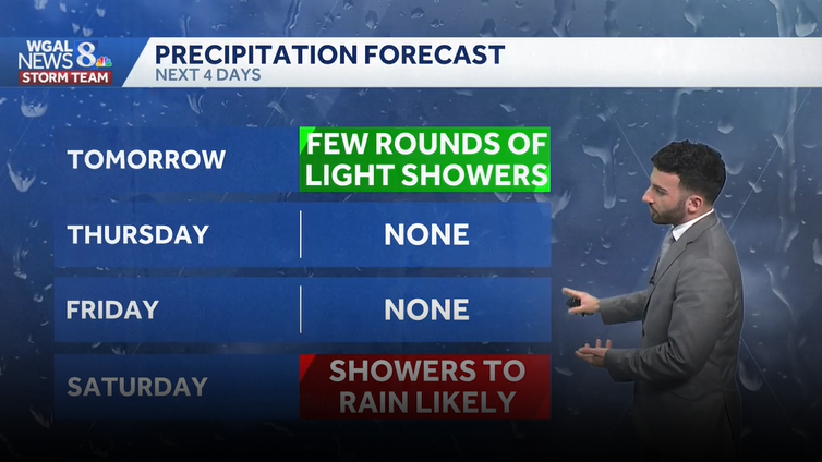
Clouds will increase late evening ahead of an approaching warm front. As the front approaches, expect sky cover to increase into the overnight tonight. It won’t be near as cold tonight with lows in the mid 40s. Scattered showers develop late. For Wednesday, a few showers are still possible with the front early, then there is an isolated chance in the afternoon as a weak cold front will sweep across the area later on. Rain amounts are light and less than 0.05″. Highs are more seasonable in the upper 60s to near 70 degrees.Thursday & Friday will feature partly to mainly sunny conditions with highs reaching the mid-70s, which is warmer than average for this time of the year. Clouds will increase later Friday as the next system approaches.The weekend starts wet with rain at times on Saturday. It is much cooler in the upper 50s. Sunday is drier but there is still an isolated shower threat with skies staying mostly cloudy. Highs do return to the low 60s.Next week, a few showers are possible Monday through Wednesday with the best chance on Tuesday. Temperatures are more consistent in the low-to-mid 60s. Overnight lows will remain in the 40s.Have a great rest of your night!~ Ryan
Clouds will increase late evening ahead of an approaching warm front. As the front approaches, expect sky cover to increase into the overnight tonight. It won’t be near as cold tonight with lows in the mid 40s. Scattered showers develop late.
For Wednesday, a few showers are still possible with the front early, then there is an isolated chance in the afternoon as a weak cold front will sweep across the area later on. Rain amounts are light and less than 0.05″. Highs are more seasonable in the upper 60s to near 70 degrees.
Thursday & Friday will feature partly to mainly sunny conditions with highs reaching the mid-70s, which is warmer than average for this time of the year. Clouds will increase later Friday as the next system approaches.
The weekend starts wet with rain at times on Saturday. It is much cooler in the upper 50s. Sunday is drier but there is still an isolated shower threat with skies staying mostly cloudy. Highs do return to the low 60s.
Next week, a few showers are possible Monday through Wednesday with the best chance on Tuesday. Temperatures are more consistent in the low-to-mid 60s. Overnight lows will remain in the 40s.
Have a great rest of your night!
~ Ryan