
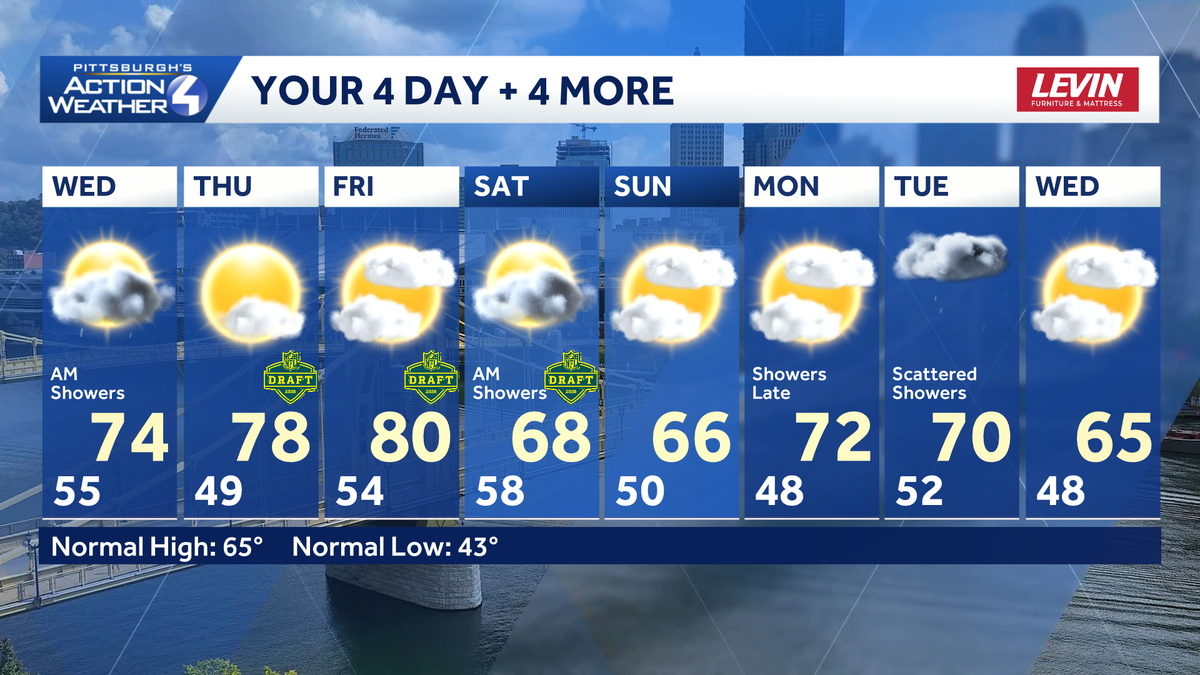
Early morning showers will leave the roads damp for the morning commute. Isolated showers will return this afternoon, primarily near the I-70. Temperatures are finally warming up, and will remain warm through late week.Showers end earlyA wave of showers is crossing western Pennsylvania early this morning. The light rain will fizzle before 7 a.m. around Allegheny County; by 9 a.m. for areas to the south. Clouds will break too, giving way to partly cloudy skies.The cold front will get hung up south of Pittsburgh. Areas near and south of I-70 may catch a brief stray shower this afternoon. The second half of the day also kicks off our warm up with highs in the low to mid 70s.NFL Draft forecastThursday and Friday will be terrific with comfortable temperatures in the 70s to near 80 degrees during the day. Partly cloudy skies will be with us on Thursday with clouds increasing on Friday as we watch the approach of another cold front.Timing questions remain about when our cold front gets here Saturday. It could arrive as early as Friday night and bring showers as the second and third rounds wrap up. The more likely outcome is that rain will arrive on Saturday, dampening Day Three of the draft.Slightly cooler this weekend and next weekSaturday’s showers will cool temperatures off. The dip in temperature extends into next week with highs in the 60s. Another round of showers will arrive late Monday and Tuesday.TODAY: Early morning showers, decreasing clouds. Milder. High: 74°.TONIGHT: Partly cloudy and comfortable. Low: 49°.THURSDAY: Warmer with sun and clouds. High: 78°, low: 54°.FRIDAY: Warm with increasing clouds. Showers are possible by the evening. High: 80°, low 58°.SATURDAY: Rain possible at times. High: 68°, low: 50°.
PITTSBURGH —
Early morning showers will leave the roads damp for the morning commute. Isolated showers will return this afternoon, primarily near the I-70. Temperatures are finally warming up, and will remain warm through late week.
Showers end early
A wave of showers is crossing western Pennsylvania early this morning. The light rain will fizzle before 7 a.m. around Allegheny County; by 9 a.m. for areas to the south. Clouds will break too, giving way to partly cloudy skies.
The cold front will get hung up south of Pittsburgh. Areas near and south of I-70 may catch a brief stray shower this afternoon. The second half of the day also kicks off our warm up with highs in the low to mid 70s.
NFL Draft forecast
Thursday and Friday will be terrific with comfortable temperatures in the 70s to near 80 degrees during the day. Partly cloudy skies will be with us on Thursday with clouds increasing on Friday as we watch the approach of another cold front.
Timing questions remain about when our cold front gets here Saturday. It could arrive as early as Friday night and bring showers as the second and third rounds wrap up. The more likely outcome is that rain will arrive on Saturday, dampening Day Three of the draft.
Slightly cooler this weekend and next week
Saturday’s showers will cool temperatures off. The dip in temperature extends into next week with highs in the 60s. Another round of showers will arrive late Monday and Tuesday.
TODAY: Early morning showers, decreasing clouds. Milder. High: 74°.
TONIGHT: Partly cloudy and comfortable. Low: 49°.
THURSDAY: Warmer with sun and clouds. High: 78°, low: 54°.
FRIDAY: Warm with increasing clouds. Showers are possible by the evening. High: 80°, low 58°.
SATURDAY: Rain possible at times. High: 68°, low: 50°.