
Few showers today, rain Saturday in south-central Pennsylvania
Rain will taper to showers Saturday afternoon; drier weather is in store Sunday
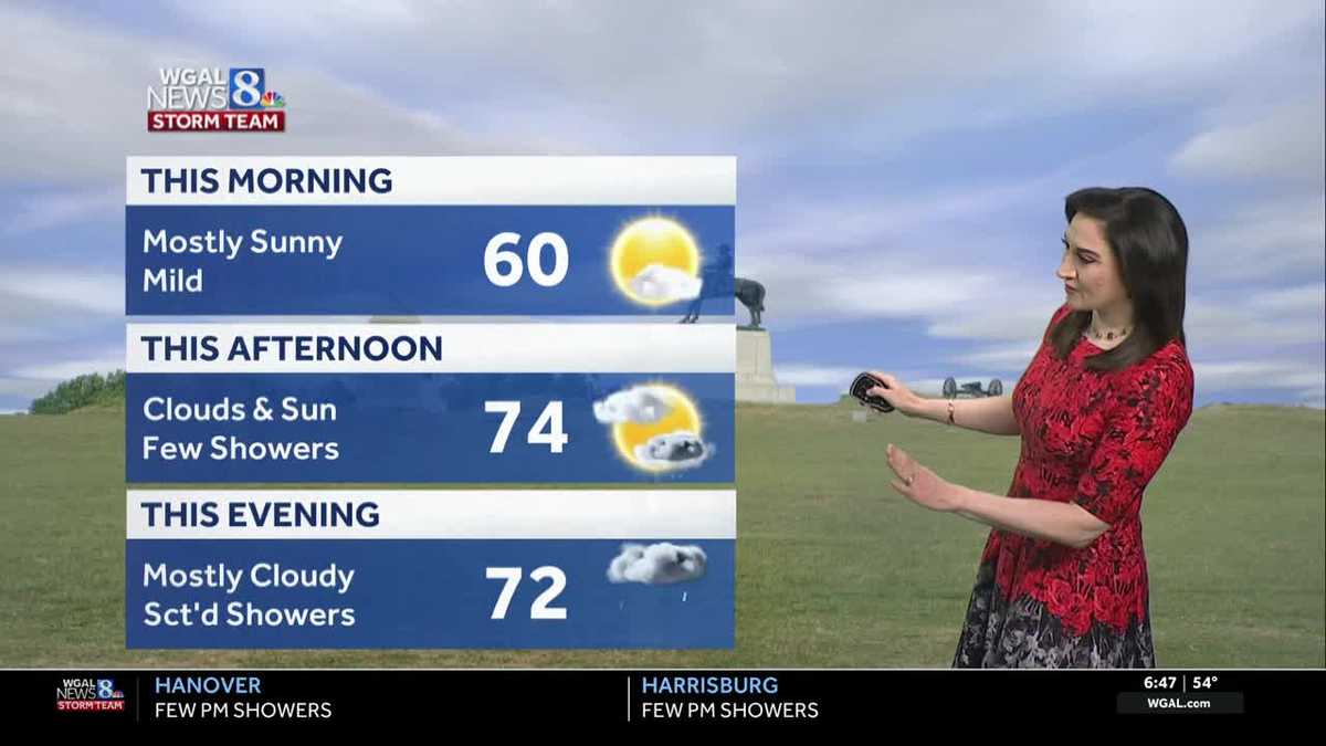
NOW, THE WGAL NEWS EIGHT STORM TEAM FORECAST WITH CHIEF METEOROLOGIST CHRISTINE FERREIRA. GOOD MORNING. IT IS 646. HERE’S A LOOK AT OUR FORECAST OVER THE NEXT COUPLE OF DAYS. TODAY, THERE’S A COUPLE OF SHOWERS THAT WILL DEVELOP IN THE AFTERNOON AND EVENING, BUT OUR HIGHS WILL STILL BE QUITE MILD AT 74. TOMORROW. HIGHS FALL TO THE 50S. SO THAT’S GOING TO BE QUITE A CHANGE. I THINK THE MORNING SHOULD BE MAINLY DRY, BUT WE DO HAVE THE CHANCE FOR RAIN, ESPECIALLY BY LUNCHTIME INTO THE AFTERNOON. IT WILL TAPER TO SHOWERS BY EVENING. SUNDAY WILL FEATURE COOL HIGHS AROUND 60. WE SHOULD SEE CLOUDS TO START THEN GRADUAL CLEARING. SO OUR NEWS EIGHT STORM TEAM FORECAST TODAY FEATURES SUNSHINE IN THE MORNING, MILD TEMPERATURES 9:00. WE ARE AT 60 DEGREES THIS AFTERNOON. A MIX OF CLOUDS AND SUNSHINE. FEW SHOWERS AROUND WEST OF THE RIVER AND THEY’LL MOVE EAST THIS EVENING UNDER MOSTLY CLOUDY SKIES. TONIGHT WE’LL KEEP THE CLOUDS AROUND SOME ISOLATED SHOWERS. CHECK OUT THE LOWS. STILL MILD, ABOVE AVERAGE IN THE 50S, AND THEN TOMORROW WE DON’T BUDGE FROM THE 50S. WE STAY IN THE 50S THERE. WITH THAT RAIN DEVELOPING. BY MIDDAY, WE GET SEVERAL HOURS OF STEADY LIGHT RAIN, AND THEN IT TAPERS TOWARD EVENING. SO THAT SHOULD HELP TO ALLEVIATE SOME OF THE DROUGHT CONDITIONS IN THE SUSQUEHANNA VALLEY. AND I’LL SHOW YOU THAT DROUGHT MONITOR COMING UP. AS FAR AS OUR TEMPERATURES GO, WE’RE AT 46 DEGREES IN LEWISTOWN, 52 IN LANCASTER, 46 IN YORK. WE HAVE A PAIR OF FOURS IN SELINSGROVE WITH 54 DEGREES. IN HARRISBURG. OUR TREE POLLEN LEVELS, YOU KNOW, THEY HAVE BEEN HIGH AND THEY CONTINUE TO BE HIGH ALL THE WAY THROUGH THE WEEKEND. FOR US, AIR QUALITY IS MODERATE TODAY AND THE UV INDEX, WE HAVE A BURN TIME OF ABOUT 40 MINUTES. STORM TEAM, LIVE RADAR NETWORK. THERE IS A BOUNDARY DRAPED RIGHT THAT’S THE BOUNDARY THAT DRIFTS INTO PENNSYLVANIA TODAY AND PROVIDES A FOCUS FOR SOME SHOWERS AND MAYBE AN ISOLATED RUMBLE OF THUNDER. SO YOU SEE THAT HERE, RIGHT? IN THE AFTERNOON. THAT’S WHEN THOSE SHOWERS BLOSSOM WEST OF THE SUSQUEHANNA RIVER. THEY’LL DRIFT EAST THIS EVENING. HIT OR MISS, VARIETY. NOT A GUARANTEE THAT YOU SEE ONE. AND THEN WE HAVE SOME ISOLATED SHOWERS TONIGHT. TOMORROW MORNING FOR ALL OUTDOOR EVENTS. I THINK WE CAN SQUEEZE IN THE RACE AGAINST RACISM IN YORK AND LANCASTER. ON A MAINLY DRY NOTE, NOTICE THAT THAT RAIN IS KNOCKING ON OUR DOORSTEP AT LUNCHTIME TOMORROW, AND THEN THE RAIN WILL COME IN FOR SEVERAL HOURS IN THE AFTERNOON, TAPERING FROM WEST TO EAST TOWARD EVENING. ALL OF THAT RAIN MOVES EAST AS WE HEAD INTO SUNDAY MORNING. SUNDAY WE START OUT CLOUDY, BUT WATCH THE CLOUDS. IN THE AFTERNOON THEY SLOWLY ERODE. SO BY THE TIME WE HIT SUNDAY EVENING, WE SHOULD FINALLY BREAK OUT INTO SOME SUNSHINE. BUT IF YOU WANT MORE SUN, YOU’LL HAVE TO WAIT UNTIL MONDAY. HERE’S THE PREDICTOR. ESTIMATED RAINFALL TOTALS FOR SATURDAY. MOST SPOTS ARE GOING TO PICK UP AROUND A QUARTER OF AN INCH TO A HALF INCH OF RAIN. THERE COULD BE SOME ISOLATED HIGHER TOTALS, SO WE’LL KEEP AN EYE ON THOSE FOR YOU NEXT WEEK. CONSISTENT TEMPERATURES IN THE 60S. AT LEAST WE DON’T HAVE TO WEAR SEVERAL DIFFERENT WARDROBES DURING THE WEEK. WE SHOULD SEE SOME SPRINGLIKE TEMP
Few showers today, rain Saturday in south-central Pennsylvania
Rain will taper to showers Saturday afternoon; drier weather is in store Sunday

Updated: 8:14 AM EDT Apr 24, 2026
A slow-moving boundary will drift across western PA today. After a round of morning sunshine, look for partly sunny skies and highs near 74 degrees. A few showers are possible this afternoon and evening, especially west of the Susquehanna River. Hit-or-miss showers will move east toward evening.Tonight, a few showers are possible under mostly cloudy skies. Lows will be mild, around 52 degrees. Saturday’s system has slowed slightly. That’s good news for Saturday morning activities! Expect mainly dry weather to start, then rain developing by afternoon. Widespread rain will taper to showers from west to east by evening. Highs will be much cooler, in the low 50s, thanks to an easterly breeze. Rain totals will range from 0.25″ to 0.50″ in most areas. Sunday will be the drier half of the weekend. Look for mostly cloudy skies and milder highs near 60. Some clearing is possible toward evening. We’ll have a dry and sunny start to the workweek, with seasonable highs in the upper 60s. As a cold front approaches late Tuesday, scattered showers will develop. Highs will reach the low 60s.Showers will end on Wednesday, and highs will be seasonable, in the mid-60s. Thursday looks dry, then the chance of showers returns Friday into Saturday. Highs will stay in the 60s next week, with lows generally in the 40s to near 50 degrees.
A slow-moving boundary will drift across western PA today. After a round of morning sunshine, look for partly sunny skies and highs near 74 degrees. A few showers are possible this afternoon and evening, especially west of the Susquehanna River. Hit-or-miss showers will move east toward evening.
Tonight, a few showers are possible under mostly cloudy skies. Lows will be mild, around 52 degrees.
Saturday’s system has slowed slightly. That’s good news for Saturday morning activities! Expect mainly dry weather to start, then rain developing by afternoon. Widespread rain will taper to showers from west to east by evening. Highs will be much cooler, in the low 50s, thanks to an easterly breeze. Rain totals will range from 0.25″ to 0.50″ in most areas.
Sunday will be the drier half of the weekend. Look for mostly cloudy skies and milder highs near 60. Some clearing is possible toward evening.
We’ll have a dry and sunny start to the workweek, with seasonable highs in the upper 60s. As a cold front approaches late Tuesday, scattered showers will develop. Highs will reach the low 60s.
Showers will end on Wednesday, and highs will be seasonable, in the mid-60s. Thursday looks dry, then the chance of showers returns Friday into Saturday. Highs will stay in the 60s next week, with lows generally in the 40s to near 50 degrees.