
Pittsburgh: Pop-up showers today, Impact Day Saturday
Widespread rain arrives Saturday morning and could last through the afternoon.
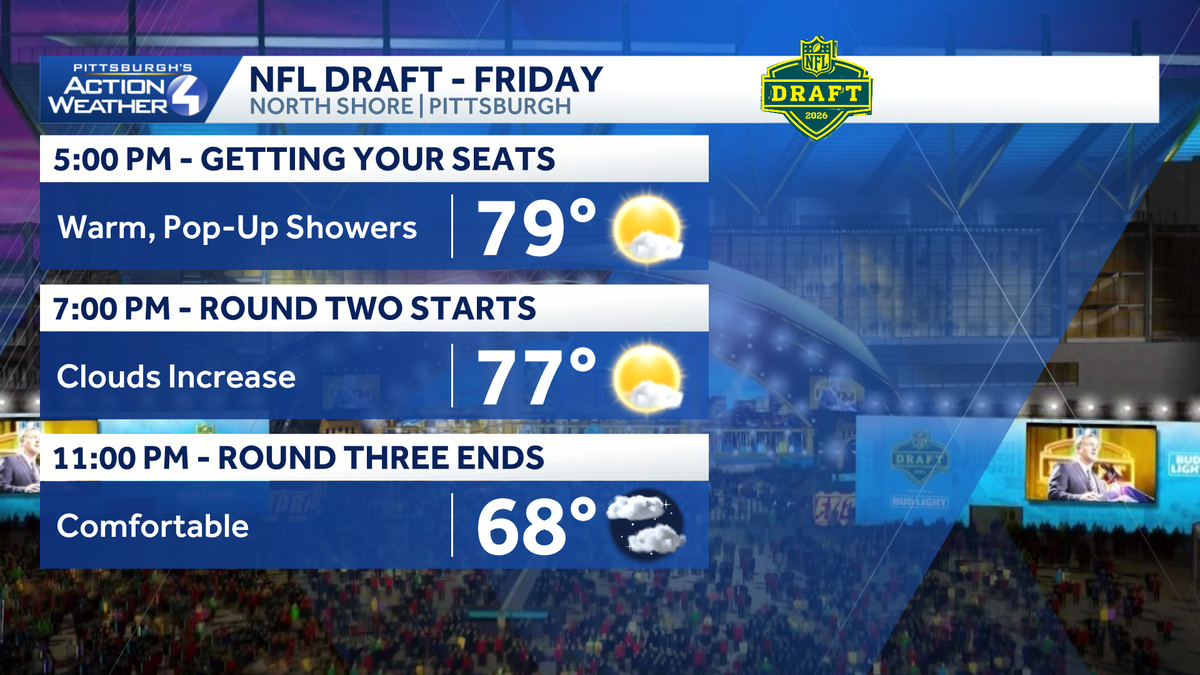
DROPPING THROUGH THE AFTERNOON. RAIN SHOWERS IN CHECK. WE WERE WATCHING FOR THIS AFTERNOON. IT’S JUST WARM ACROSS WESTERN PENNSYLVANIA. WE ARE FLIRTING WITH 80 DEGREES, COUPLE DEGREES ON EITHER SIDE DEPENDING ON WHERE YOU ARE. BUT AGAIN, HUMIDITY IS DROPPED SO IT’S NOT UNBEARABLE, BUT IT IS WARM OUTSIDE. WE’LL STILL BE IN THE UPPER 70S AS ROUND TWO GETS UNDERWAY HERE AT 7:00. IT WILL BE ABOUT 68 BY THE TIME WE GET TO THE END OF ROUND THREE. WE SHOULD KEEP THE RAIN SHOWERS AWAY. WE’VE BEEN DOING A PRETTY GOOD JOB OF THAT SO FAR THIS AFTERNOON. YOU KIND OF SEE RAIN IS GENERALLY CONFINED IN THIS ARC NORTH OF THE CITY. THAT’S WHERE THE WARM FRONT IS SITTING SOUTH OF THAT, IT’S BEEN HARD FOR SHOWERS TO BUBBLE UP. IF IT DOES, IT LAST ABOUT 10 OR 15 MINUTES AND THEN FALLS APART. SO SO FAR WE’VE BEEN GOOD ACROSS WESTERN PENNSYLVANIA, AND THAT SHOULD HOLD AS ANY RAIN THAT TRIES TO DEVELOP WILL FALL APART AFTER SUNSET. 69 HIGH TEMPERATURE TOMORROW. TOMORROW, THOUGH, IS AN IMPACT DAY. RAIN WILL BE AROUND FOR A GOOD PORTION OF THE DAY TOMORROW. WE’LL DRY OUT ON SUNDAY AT 6573 ON MONDAY. ANOTHER COLD FRONT IS HERE ON TUESDAY THAT BRINGS RAIN SHOWERS THAT LIKELY LINGERS INTO YOUR WEDNESDAY AS WELL. AND THEN TEMPERATURES START HEADING IN THE OPPOSITE DIRECTION FOR THE REST OF THE WEEK. WE GO FROM 68 ON WEDNESDAY TO 65 THURSDAY, 60 ON FRIDAY, AND WE’RE IN THE 50S NEXT SATURDAY. GOING TO BE A BIT CHILLY FOR THE KIDS OF STEEL AND OTHER EVENTS ON SATURDAY FOR THE PITTSBURGH MARATHON. SO AGAIN, OUTSIDE OF A QUICK POP UP SHOWER MAINLY NORTH OF THE CITY, WE ARE DRY. AS WE HEAD THROUGH THE REST OF THE EVENING. WE’RE WATCHING A COLD FRONT THAT BEGINS APPROACHING FROM OUR WEST OVERNIGHT. THERE COULD BE A COUPLE OF SHOWERS EARLY. A LOT OF THE RAIN THOUGH IS HERE TOMORROW MORNING, SO IF YOU’RE HEADING DOWN FOR THE DRAFT, FIVE K RAIN SHOWERS WILL BE AROUND. AND THEN WE KIND OF KEEP PERIODS OF RAIN AROUND AS WE HEAD THROUGH YOUR SATURDAY, LIKELY CLEARING OUT AS WE HEAD INTO THE MIDDLE OF THE LATTER PORTION OF THE AFTERNOON. SO THERE WILL BE RAIN SHOWERS AROUND AS WE START ROUNDS FOR TOMORROW OF THE NFL DRAFT. BUT THAT RAIN SHOULD EXIT. AS WE HEAD THROUGH THE AFTERNOON. WE’LL START WITH CLOUDS AND PERHAPS SOME FOG ON SUNDAY BEFORE SKIES BRIGHTEN UP AS WE HEAD THROUGH THE REST OF THE AFTERNOON. SO IF YOU’RE MAKING PLANS DOWNTOWN, MAKE SURE YOU GRAB THE SUNGLASSES HERE ON ACTION CAM. IT’S A NICE AFTERNOON. 79 IS THE CURRENT TEMPERATURE. WINDS ARE WEST AT TEN MILES PER HOUR. AGAIN, WE’LL HOLD NEAR 80 FOR ANOTHER COUPLE OF HOURS AND WE WILL SLOWLY DROP OFF TONIGHT. YOU’LL WANT THE RAIN IF YOU’RE HEADING OUT TOMORRO
Pittsburgh: Pop-up showers today, Impact Day Saturday
Widespread rain arrives Saturday morning and could last through the afternoon.

Updated: 4:31 PM EDT Apr 24, 2026
A cold front Saturday morning will bring rain showers and prompts an Impact Day.NFL Draft forecastA cold front approaching late tonight and into early Saturday morning will bring scattered rain showers. Saturday will be an Impact Day. The timing of the cold front has slowed down today, meaning the Draft Friday night should be fine. However, rain showers likely linger into Saturday afternoon, past the noon start of Round Four. There is a chance rain showers last all afternoon.Slightly cooler this weekend and next weekSaturday’s showers will cool temperatures off. The dip in temperatures extends into next week with highs in the 60s. Another round of showers will arrive late Tuesday. Tuesday’s rain will likely be the most we see over the course of the next week.Temperatures will steadily fall and cooler air will be around for Pittsburgh Marathon weekend.TONIGHT: Cloudy, Rain developing late. Low 59°SATURDAY – Impact Day: Rain at times, especially in the morning. High: 69°, low: 48°.SUNDAY: Mostly to partly cloudy. High: 65°, low: 44°.
PITTSBURGH —
A cold front Saturday morning will bring rain showers and prompts an Impact Day.
NFL Draft forecast
A cold front approaching late tonight and into early Saturday morning will bring scattered rain showers. Saturday will be an Impact Day. The timing of the cold front has slowed down today, meaning the Draft Friday night should be fine. However, rain showers likely linger into Saturday afternoon, past the noon start of Round Four. There is a chance rain showers last all afternoon.

Hearst Owned
Rain showers could linger all afternoon Saturday around Pittsburgh, prompting the Impact Day. You will need the rain gear for the NFL Draft.
Slightly cooler this weekend and next week
Saturday’s showers will cool temperatures off. The dip in temperatures extends into next week with highs in the 60s. Another round of showers will arrive late Tuesday. Tuesday’s rain will likely be the most we see over the course of the next week.
Temperatures will steadily fall and cooler air will be around for Pittsburgh Marathon weekend.

Hearst Owned
A few chances at rain leads to more seasonal temperatures to close out April. Cooler air arrives for the start of May.
TONIGHT: Cloudy, Rain developing late. Low 59°
SATURDAY – Impact Day: Rain at times, especially in the morning. High: 69°, low: 48°.
SUNDAY: Mostly to partly cloudy. High: 65°, low: 44°.