
Impact Day Wednesday with thunderstorms, heavy rain
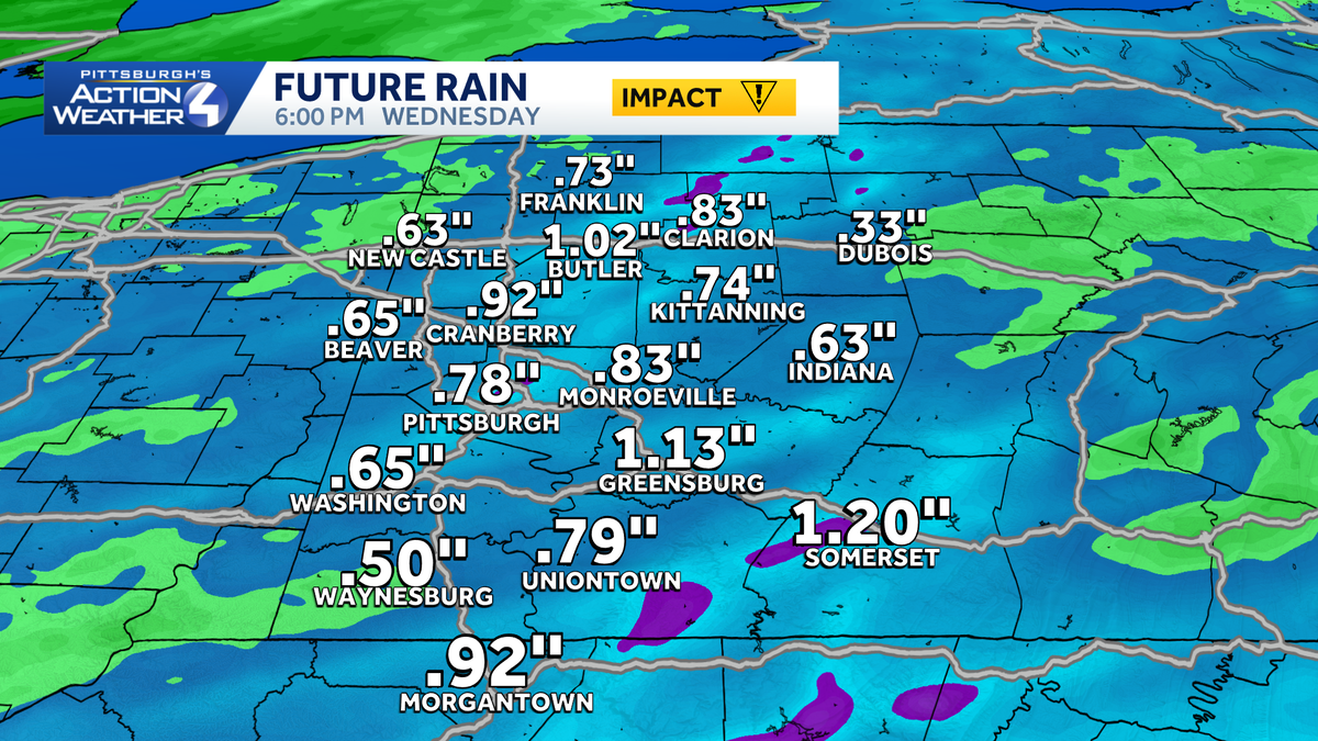
Up to an inch of localized rain is possible by late Wednesday around western PA.
SO THIS IS GOING TO START EARLY IN THE MORNING RIGHT BRIAN. YEAH. THIS WILL START DURING THE COMMUTE. IN FACT IF YOU ARE A COMMUTER TOMORROW, YOU’LL LIKELY RUN INTO SOME RAIN SHOWERS. SO KIND OF FLIP WHAT WE SAW TODAY. EARLY COMMUTERS WILL LIKELY BE OKAY ALONG WITH THE HIGH SCHOOL KIDS OUT THE DOOR, BUT THEN WIDESPREAD RAIN WILL ARRIVE. COULD BE A COUPLE OF THUNDERSTORMS TOMORROW AS WELL. NOT EXPECTING WIDESPREAD SEVERE WEATHER, BUT A THUNDERSTORM OR TWO IS POSSIBLE. AND IF THEY GET STRONG, SOME GUSTY WINDS AND SMALL HAIL WILL BE THE PRIMARY CONCERNS. THEN WE KEEP A SHOWER CHANCE THURSDAY AND FRIDAY. BUT THE MAIN STORY IS NOT REALLY THAT RAIN CHANCE. IT’S THE CHILL AS HIGH TEMPERATURES DROP INTO THE 50S, WHICH IS WHERE OUR LOWS HAVE BEEN FOR THE LAST SEVERAL DAYS. SO 64 TOMORROW AGAIN, WE’LL START AT 55. IT’S AN IMPACT DAY WITH RAIN AND STORMS. THOSE SHOWER CHANCES THURSDAY AND FRIDAY, TEMPERATURES ONLY IN THE 50S WILL START IN THE 30S ON FRIDAY, SATURDAY AND ON SUNDAY MORNING. SO IT’S GOING TO BE CHILLY AS WE HEAD THROUGH THE WEEKEND. HIGH TEMPERATURES STAY IN THE 50S FOR THE MARATHON. GREAT NEWS FOR THE RUNNERS. BAD NEWS IF YOU’LL BE WATCHING ON THE SIDELINES, IT WILL BE CHILLY. WE’RE BACK INTO THE MID AND UPPER 60S MONDAY, TUESDAY AND WEDNESDAY WITH SCATTERED SHOWER CHANCES MONDAY AND WEDNESDAY AND A COUPLE SHOWERS POSSIBLE AS WE HEAD INTO TUESDAY. TOMORROW IS THE BIG RAIN DAY THOUGH. AS WE HEAD THROUGH THE NIGHT. CLOUDS WILL INCREASE TONIGHT. TOMORROW MORNING AROUND 6 OR 7:00, OUR FIRST BATCH OF RAIN BEGINS ARRIVING, ESPECIALLY SOUTH OF PITTSBURGH. THERE COULD BE AN EMBEDDED THUNDERSTORM WITH THIS, AND THEN WIDESPREAD RAIN SPILLS IN AS WE CONTINUE THROUGH THE MORNING, MOST OF US SEE RAIN BY 10:00 LUNCHTIME. STILL SEEING PLENTY OF RAIN ACROSS WESTERN PENNSYLVANIA. AND THEN WE START BACKING OFF THE COVERAGE AFTER ABOUT 1:00 OR 2:00 WITH JUST SOME STRAY SHOWERS AS WE GET TOWARDS THE EVENING COMMUTE, WE’LL TRY AND DRY OUT. THEN AS WE HEAD INTO THURSDAY MORNING. BUT WE’LL WATCH NORTHWEST OF THE CITY AS OUR WINDS TURN NORTHWEST. A COUPLE OF LAKE EFFECT RAIN SHOWERS WILL FILTER ACROSS WESTERN PENNSYLVANIA ON THURSDAY, AND THAT WILL HOLD AS WE HEAD INTO YOUR FRIDAY, AS WELL AS COOLER AIR COMES ACROSS THE LAKES AND ALLOWS FOR A COUPLE OF RAIN SHOWERS TO DEVELOP TOMORROW. STILL A SOGGY DAY THAT WE’RE EXPECTING. ABOUT A HALF INCH TO AN INCH OF RAIN ACROSS WESTERN PENNSYLVANIA, WITH SOME LOCALLY HIGHER AMOUNTS, SO IT’S GOING TO BE A SOGGY PERIOD. IF YOU ARE HEADING OUT TONIGHT FOR THE PIRATES GAME, BUT WE SHOULD GET THE GAME IN FINE AS SKIES ARE ATTEMPTING TO CLEAR. TEMPERATURES WILL BE IN THE 60S. TH
Impact Day Wednesday with thunderstorms, heavy rain
Up to an inch of localized rain is possible by late Wednesday around western PA.

Updated: 6:49 PM EDT Apr 28, 2026
Another system arrives in Western PA, Wednesday morning. It will bring rain for a good portion of the day. Conditions will dry out and cool down late week.More rain WednesdayThe first half of Wednesday will be wetter with rain quickly taking over after sunrise. Locally heavy rain is expected. A half inch to one inch of rain is expected. The rain will end from west and east during the early afternoon. Another batch of isolated showers will pop up during the afternoon.We still can’t rule out an isolated thunderstorm tomorrow morning. The best chances will be south of Pittsburgh. Small hail and gusty winds are the storm threats. A second chance at storms will exist in the mid-afternoon hours south and east of Pittsburgh.Much cooler through the weekend Temperatures will be cooler by the end of the week. Mornings will be in the 30s with the potential for frost north and east of Pittsburgh starting Friday. Isolated showers will be possible each day.Daytime readings in the 50s are expected for Pittsburgh Marathon weekend. Conditions should be dry for runners and spectators.OVERNIGHT: Mostly cloudy and mild. Low: 55°.WEDNESDAY – Impact Day: Rain with embedded storms and heavy rain during the morning. Scattered afternoon showers/t’storms. Breezy. High: 64°, low: 42°.THURSDAY: Cooler with some sunshine. Isolated showers. High: 56°, low: 39°.FRIDAY: Areas of frost possible. Mostly cloudy with isolated showers possible. High: 55°, low: 36°.
PITTSBURGH —
Another system arrives in Western PA, Wednesday morning. It will bring rain for a good portion of the day. Conditions will dry out and cool down late week.
More rain Wednesday
Hearst OwnedHearst
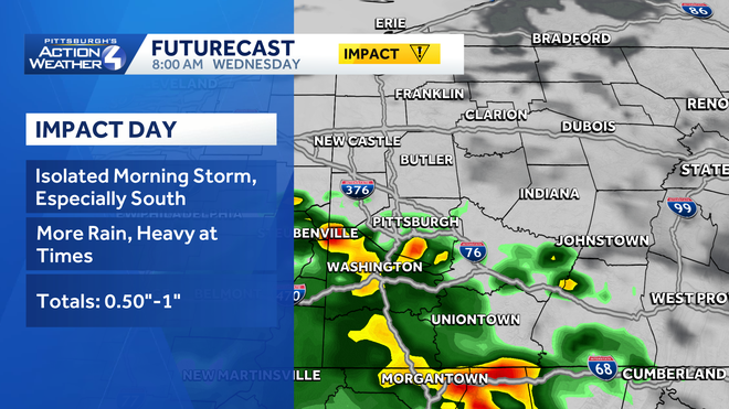
Wednesday’s Impact Day begins with isolated downpours and storms.
The first half of Wednesday will be wetter with rain quickly taking over after sunrise. Locally heavy rain is expected. A half inch to one inch of rain is expected. The rain will end from west and east during the early afternoon. Another batch of isolated showers will pop up during the afternoon.
Hearst OwnedHearst
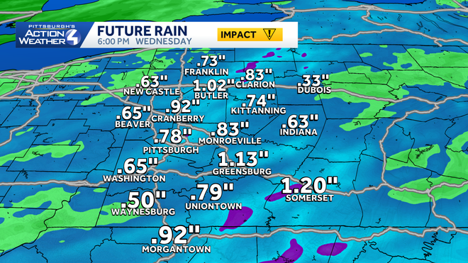
Localized pockets of heavy rain and storms could produce up to an inch of rain by the end of Wednesday.
We still can’t rule out an isolated thunderstorm tomorrow morning. The best chances will be south of Pittsburgh. Small hail and gusty winds are the storm threats. A second chance at storms will exist in the mid-afternoon hours south and east of Pittsburgh.
Much cooler through the weekend
Temperatures will be cooler by the end of the week. Mornings will be in the 30s with the potential for frost north and east of Pittsburgh starting Friday. Isolated showers will be possible each day.
Daytime readings in the 50s are expected for Pittsburgh Marathon weekend. Conditions should be dry for runners and spectators.
Hearst Owned
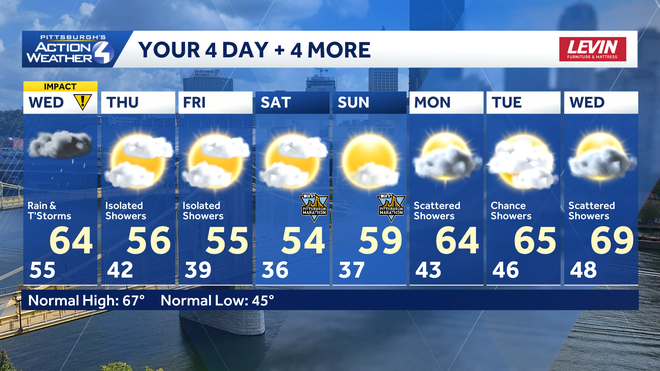
Frosty mornings and cool afternoons through the early days of May. The pattern remains quiet and dry into early next week.
OVERNIGHT: Mostly cloudy and mild. Low: 55°.
WEDNESDAY – Impact Day: Rain with embedded storms and heavy rain during the morning. Scattered afternoon showers/t’storms. Breezy. High: 64°, low: 42°.
THURSDAY: Cooler with some sunshine. Isolated showers. High: 56°, low: 39°.
FRIDAY: Areas of frost possible. Mostly cloudy with isolated showers possible. High: 55°, low: 36°.