
Western PA: Rain with isolated storms return
The best storm chance will be for Pittsburgh and areas to the south through the early afternoon.
MAKE SURE THE REST OF YOUR FAMILY DOESN’T GET SICK. IT IS AN IMPACT DAY FOR US TODAY. RIGHT NOW, WE ARE DEALING WITH A LITTLE BIT OF PATCHY FOG. ACTUALLY, SKY 4 HAS TO LAND FOR SAFETY BECAUSE THAT FOG IS STARTING TO BLANKET, ESPECIALLY ALONG THE RIVERS INTO ALLEGHENY COUNTY. WIDESPREAD RAIN AND STORMS EXPECTED. GRAB THE UMBRELLA BEFORE YOU HEAD OUT. GETTING INTO THURSDAY AND FRIDAY WILL COOL DOWN AND A CHANCE FOR A FEW ISOLATED SHOWERS. WE’VE BEEN WATCHING THIS RAIN ALL MORNING LONG, AND SOME THUNDERSTORMS CONTINUE TO WEAKEN, ALTHOUGH GETTING INTO BELMONT, OHIO, STILL SEEING SOME LIGHTNING THERE AND WATCHING WHAT’S JUST GETTING CLOSER TO GREENE COUNTY. SO AS WE GET TOWARDS THE TAIL END OF OUR MORNING COMMUTE AND INTO LATE MORNING THROUGH THE AFTERNOON, THIS RAIN AND ISOLATED STORMS WILL BE FIRING OFF. AND YOU CAN SEE A LOT OF IT IS STILL WELL TO OUR WEST. SO THIS HAS CHANGED A LITTLE BIT FROM YESTERDAY. THE STORM PREDICTION CENTER HAS UPPED WHERE OUR ISOLATED RISK FOR STRONG STORMS NOW UP ALONG 422 INTO SOUTHERN. BUTLER. ALSO ARMSTRONG AND IIANA EXTENDING INTO BEAVER ALSO ALLEGHENY, WASHINGTON, GREENE EVEN INTO WESTMORELAND AND FAYETTE DOWN INTO MORGANTOWN. BIGGEST STORM THREAT IS GOING TO BE DAMAGING WIND GUSTS. EVERYTHING ELSE LOOKS TO BE ON THE LOW SIDE. BUT AGAIN, WE COULD HAVE THOSE WINDS PICKING UP THAT COULD BE DAMAGING, ESPECIALLY OVER 40MPH, BUT VERY ISOLATED AS WE LOOK AT OUR FUTURECAST, AROUND 7:00, START TO SEE A SPOTTY SHOWER, BUT STILL A LOT OF IT TO OUR WEST STARTS TO COME IN AROUND 8:00, 9:00 AS EXPECTED. AND AGAIN, AN ISOLATED STORM CANNOT BE RULED OUT. WE WILL HAVE POCKETS OF HEAVY RAIN. AT TIMES. IT WILL DROP YOUR VISIBILITY AND PUT PONDING ON THE ROADWAYS. LITTLE BREAKS AT TIMES IN SOME SPOTS, AS WE GET CLOSER TO 3:00, 4:00, THE KIDS COMING HOME FROM SCHOOL, YOU’RE HEADING HOME FROM WORK. THERE WILL BE, AGAIN, I’M SURE, SOME DELAYS WITH SOME OF THE HEAVY RAIN ROLLING THROUGH AFTER SEVEN STARTS TO MOVE OUT, YOU’LL STILL HAVE IT INTO CAMBRIA AND SOMERSET, BUT THEN IT PUSHES ON OUT. WE QUIET DOWN INTO THE OVERNIGHT, MOSTLY CLOUDY SKIES. WE’LL SEE THOSE CLOUDS BREAK A LITTLE BIT, BUT ALSO A CHANCE FOR A SPRINKLE OR A POP UP SHOWER. VERY ISOLATED, VERY LIGHT IN NATURE. JUST DON’T BE SURPRISED. BE LIKE, OH, I JUST HAD A LITTLE BIT OF A LIGHT SHOWER PUSH THROUGH MY NEIGHBORHOOD. IT’S NOT GOING TO BE THAT BIG OF A DEAL, BUT IT WILL MOVE THROUGH. YOU WILL NOTICE THE DROP IN TEMPERATURES THOUGH. DAYTIME HIGHS OVER THE NEXT THREE DAYS, ONCE WE GET THROUGH TODAY WILL BE WHAT WE’RE EXPERIENCING THIS MORNING INTO THE MID TO UPPER 50S 55 RIGHT NOW, PITTSBURGH AND GREENSBURG, 52 IN KITTANNING, 50 IN BEAVER AND NEW CASTLE. UNIONTOWN AT 58. MORGANTOWN AT 60 DEGREES. SO WE ARE GOING TO JUMP UP NEAR 60 FOR TODAY. WE’LL HAVE A RAIN AND STORMS. BREEZY THROUGH THE AFTERNOON WILL BE BREEZY INTO TOMORROW WITH A POP UP SHOWER. CAN’T RULE OUT AN ISOLATED SHOWER ON FRIDAY, ESPECIALLY IN THE MORNING, BUT WE ARE GOING TO DRY OUT FOR MARATHON WEEKEND. BUT BOY IT WILL BE COLD IN THE MORNING. MID TO UPPER 30S WILL BE IN THE MID 50S. A LITTLE BIT MORE CLOUD COVER ON SATURD
Western PA: Rain with isolated storms return
The best storm chance will be for Pittsburgh and areas to the south through the early afternoon.

Updated: 6:52 AM EDT Apr 29, 2026
Another system arrives for western Pennsylvania this morning, prompting the second Impact Day in a row. This will be a good soaker with isolated storms, especially south of Pittsburgh. Conditions will dry out and cool down through the weekend.Impact Day: Rain returns late-morning with isolated stormsRain is still on track to quickly take over after sunrise. Activity will arrive from the southwest. Heavy rain is expected with rain totals of half an inch to one inch. We still can’t rule out an isolated thunderstorm starting late morning. The best chances will be south of Pittsburgh. Gusty winds and small hail are the storm threats. A second chance at storms will exist in the mid-afternoon hours south and east of Pittsburgh.Cooling down with isolated showersTemperatures will be cooler by the end of the week. Mornings will be in the 30s with the potential for frost north and east of Pittsburgh starting Friday. Isolated showers will be possible each day.Pittsburgh Marathon weekendConditions should be dry for runners and spectators of the Pittsburgh Marathon. The start of the races will be chilly ahead of daytime readings only in the 50s. TODAY – Impact Day: More rain with a few storms, especially south. High: 64°.TONIGHT: Showers end, mostly cloudy with patchy fog. Low: 42°.THURSDAY: Cooler with clouds and isolated showers possible. High: 56°, low: 39°.FRIDAY: Cool again with isolated showers. High: 55°, low: 36°.SATURDAY: Frosty start, unseasonably cool finish with more clouds than sun. High: 54°, low: 37°.
PITTSBURGH —
Another system arrives for western Pennsylvania this morning, prompting the second Impact Day in a row. This will be a good soaker with isolated storms, especially south of Pittsburgh. Conditions will dry out and cool down through the weekend.
Impact Day: Rain returns late-morning with isolated storms
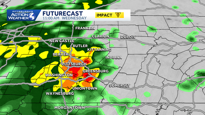
Rain is still on track to quickly take over after sunrise. Activity will arrive from the southwest. Heavy rain is expected with rain totals of half an inch to one inch.
Hearst OwnedHearst
Rain arrives from the southwest after 8 a.m. or 9 a.m. The Impact Day also includes the potential for isolated strong to severe storms.
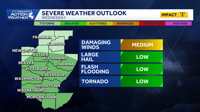
We still can’t rule out an isolated thunderstorm starting late morning. The best chances will be south of Pittsburgh. Gusty winds and small hail are the storm threats. A second chance at storms will exist in the mid-afternoon hours south and east of Pittsburgh.
Hearst OwnedHearst
An isolated risk for severe storms today for most of western Pennsylvania.
Cooling down with isolated showers
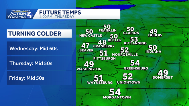
Temperatures will be cooler by the end of the week. Mornings will be in the 30s with the potential for frost north and east of Pittsburgh starting Friday. Isolated showers will be possible each day.
Hearst OwnedHearst
Temperatures trend cooler through late-week with a daily dose of hit or miss showers.
Pittsburgh Marathon weekend
Conditions should be dry for runners and spectators of the Pittsburgh Marathon. The start of the races will be chilly ahead of daytime readings only in the 50s.
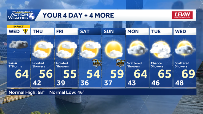
Hearst OwnedHearst
More seasonal temperatures return early next week with daily shower chances.
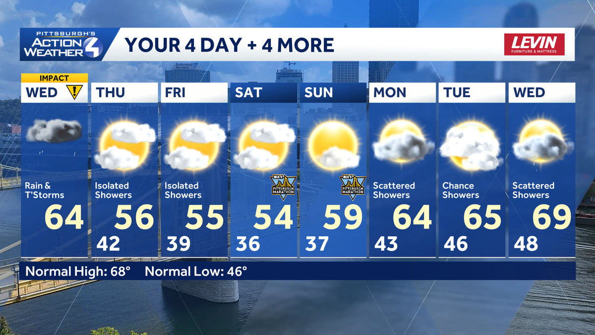
TODAY – Impact Day: More rain with a few storms, especially south. High: 64°.
TONIGHT: Showers end, mostly cloudy with patchy fog. Low: 42°.
THURSDAY: Cooler with clouds and isolated showers possible. High: 56°, low: 39°.
FRIDAY: Cool again with isolated showers. High: 55°, low: 36°.
SATURDAY: Frosty start, unseasonably cool finish with more clouds than sun. High: 54°, low: 37°.