
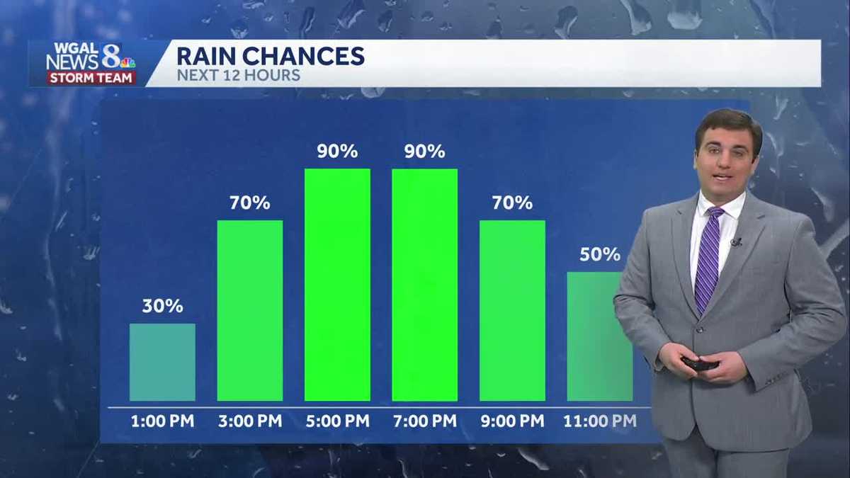
THE TEAM WILL BE IN HOUSTON THROUGH SATURDAY. NOW, THE WGAL NEWS EIGHT STORM TEAM FORECAST WITH METEOROLOGIST MIKE SUSKO. GOOD AFTERNOON EVERYONE. AS THE RAIN COMES IN. SOME OF THEM, ESPECIALLY OUR SOUTHWESTERN COUNTIES, FRANKLIN AND ADAMS COUNTY, COULD BE A BIT ON THE STRONG SIDE. IT REALLY JUST DEPENDS ON HOW MUCH OF THAT WARMER AIR FROM THE SOUTH CAN GET IN HERE. AND IF WE CAN GET SOME INSTABILITY, BUT BE ON THE LOOK OUT FOR MAYBE A STRONG STORM OR TWO LATER ON THIS AFTERNOON, EVENING AS THE RAIN MOVES ON IN, THERE WILL BE A CHANCE FOR SOME GUSTY WINDS WITH IT, BUT MOST OF US WILL NOT BE SEEING ANY SEVERE WEATHER THERE. YOU CAN SEE IT’S A RELATIVELY LOW THREAT. WE ARE SEEING THE SHOWERS AND STORMS THOUGH STARTING TO MOVE INTO THE AREA, ESPECIALLY IN MIFFLIN AND JUNIATA COUNTY. THERE WE’RE SEEING SOME LIGHT TO MODERATE RAIN AT TIMES NEAR THOMPSONTOWN PORT ROYAL. THEY’RE GETTING SOME OF THAT MORE MODERATE TO HEAVY RAIN IN MCALISTERVILLE AS WELL, AND EVEN REEDS GAP SEEING A LITTLE BIT MORE OF THAT MODERATE RAIN. WATERLOO GOING BACK AND FORTH A LITTLE BIT WITH SOME ON AND OFF SHOWERS AND SAME THING IN LANE DOWN IN FRANKLIN COUNTY. WE’VE BEEN SEEING A FEW SPOTTY SHOWERS, ALTHOUGH A LITTLE BIT STEADIER RAIN AS YOU HEAD UP TOWARDS NEWBURGH AND ALSO SHIPPENSBURG AREA. WILL HILL ALSO SEEING SOME OF THAT LIGHT RAIN THERE. WE’LL CONTINUE TO SEE THIS RAINFALL FILL IN ACROSS THE AREA AS WE GO THROUGH THE AFTERNOON AND EVENING. SO LET’S TIME THIS OUT FOR YOU. YOU CAN SEE HOW THAT RAIN MOVES IN OVER THE NEXT FEW HOURS. IT’S STEADY AT TIMES, EVEN MODERATE TO HEAVY AT PERIODICALLY AS WE GO THROUGH THE EVENING COMMUTE HOURS. AND THEN NOTICE HOW THERE’S A LITTLE BIT OF A BREAK UP HERE AS THE LOW MOVES OVER. SO THERE WILL BE PERIODS WHERE IT’S ON AND OFF AS WE GO THROUGH THE AFTERNOON AND EVENING. AND THAT MIGHT BE AN OPPORTUNITY TO GET OUTSIDE IF YOU HAVE TO DO ANYTHING LATER ON THIS EVENING BEFORE THIS LOW FINALLY MOVES OFF TO THE EAST AND WE SEE THINGS GET A LITTLE BIT QUIETER OVERNIGHT TONIGHT. BY TOMORROW MORNING, WE WILL BE SEEING A LITTLE BIT OF FOG POSSIBLY, BUT OTHERWISE IS GOING TO BE A QUIET START. A SPOTTY SHOWER TOMORROW, ESPECIALLY NORTH OF TURNPIKE. NOT OUT OF THE QUESTION, BUT MOST OF US STAY DRY AS WE GO INTO YOUR THURSDAY. AND THEN AS WE HEAD INTO FRIDAY, PRETTY MUCH THE SAME DEAL. WE HAVE HIGH PRESSURE COMING INTO CONTROL FOR YOUR FRIDAY, BUT A LITTLE BIT OF MOISTURE IN NORTHEASTERN PENNSYLVANIA MAY TRIGGER AN ISOLATED SHOWER OR TWO IN THE AFTERNOON, AND THEN A LITTLE BIT OF MOISTURE BEHIND THE SYSTEM, HIGH PRESSURE THERE AS WE GO INTO FRIDAY NIGHT, MAY OFFER AN ISOLATED SHOWER LATE FRIDAY NIGHT, MAINLY AFTER SUNSET HERE. BUT TODAY DEFINITELY GOING TO BE THE BEST CHANCE TO GET SOME RAIN, INCLUDING HERE IN HARRISBURG. YOU’LL BE SEEING THE RAIN WITHIN THE NEXT PROBABLY HOUR OR TWO BEFORE THINGS BECOME A LITTLE BIT MORE. STAY WITH THAT RAIN THIS AFTERNOON. 56 THE CURRENT TEMPERATURE THERE. WE’LL DROP BACK TO AROUND 50 DEGREES FOR THE OVERNIGHT LOW. MOSTLY CLOUDY, WITH THOSE SHOWERS ENDING AS WE HEAD TOWARDS THE MIDNIGHT HOUR AND THEN AGAIN WATCH FOR SOME PATCHY FOG TOMORROW MORNING. PARTLY SUNNY, STRAY SHOWER AS WE GO INTO YOUR THURSDAY, WITH A HIGH AROUND 62. IT’S GOING TO BE A BUSY DAY TOMORROW. WINDS OUT OF THE NORTHWEST AROUND 10 TO 20MPH ON YOUR THURSDAY. AND AS WE GO INTO FRIDAY AND COOLER STILL AROUND 58 FOR THAT HIGH WITH A FEW SHOWERS AROUND. BUT WE DO SEE THE WINDS GET A LITTLE BIT QUIETER AS WE HEAD INTO YOUR SATURDAY. COOL BUT DRY. AND SAME THING ON SUNDAY. ALTHOUGH SUNDAY IS GOING TO BE BREEZY ONCE AGAIN, WE GET U
Afternoon & Evening Rain Across South-Central Pennsylvania
A soaking rain is in store today; temperatures will remain cool through early next week

Updated: 1:01 PM EDT Apr 29, 2026
Good afternoon, Steady rain will develop west of the Susquehanna River, then move east this afternoon. Periods of moderate to briefly heavy rain are possible through the evening, and highs will reach 60 degrees.The Storm Prediction Center has highlighted Franklin and Adams Counties in a “Marginal Risk” for an isolated severe storm. Damaging wind gusts are the main threat. However, clouds, cool temperatures, and rain may hamper the development of severe storms.As drought conditions continue across the Susquehanna Valley, a soaking rain is needed, and we’ll likely get around 0.50″ to 1″ of rain from this system, with isolated higher totals.Tonight, showers will end around midnight, and lows will fall to 50 degrees under mostly cloudy skies. Look for some clearing toward sunrise.Thursday will feature partly sunny conditions and highs near 62 with a 10-20 mph northwesterly breeze. A stray shower can’t be ruled out.Temperatures will hover near 60 on Friday, which is about 10 degrees below average. A few showers are possible as a disturbance moves across Pennsylvania.Saturday looks mainly dry, but cloudy, and Sunday will be dry with more sunshine. Weekend temperatures will remain near 60 degrees.Next week, highs will be more seasonable, in the upper 60s to low 70s, Monday through Thursday. A chance of showers returns Tuesday into Wednesday, and again on Thursday.Have a great day!
Good afternoon,
Steady rain will develop west of the Susquehanna River, then move east this afternoon. Periods of moderate to briefly heavy rain are possible through the evening, and highs will reach 60 degrees.
The Storm Prediction Center has highlighted Franklin and Adams Counties in a “Marginal Risk” for an isolated severe storm. Damaging wind gusts are the main threat. However, clouds, cool temperatures, and rain may hamper the development of severe storms.
As drought conditions continue across the Susquehanna Valley, a soaking rain is needed, and we’ll likely get around 0.50″ to 1″ of rain from this system, with isolated higher totals.
Tonight, showers will end around midnight, and lows will fall to 50 degrees under mostly cloudy skies. Look for some clearing toward sunrise.
Thursday will feature partly sunny conditions and highs near 62 with a 10-20 mph northwesterly breeze. A stray shower can’t be ruled out.
Temperatures will hover near 60 on Friday, which is about 10 degrees below average. A few showers are possible as a disturbance moves across Pennsylvania.
Saturday looks mainly dry, but cloudy, and Sunday will be dry with more sunshine. Weekend temperatures will remain near 60 degrees.
Next week, highs will be more seasonable, in the upper 60s to low 70s, Monday through Thursday. A chance of showers returns Tuesday into Wednesday, and again on Thursday.
Have a great day!