
Cooler conditions today with a few showers; more showers for Friday in south-central Pennsylvania
Weekend looking mainly dry & cloudier. Highs will stay near 60 degrees through Sunday. Milder trend in temperatures expected next week.
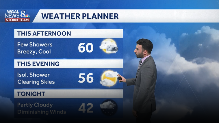
THE EVENT. NOW, THE WGAL NEWS EIGHT STORM TEAM FORECAST WITH METEOROLOGIST RYAN ARGENTI. YOU SEE SOME SUNSHINE BREAKING OUT OF THE CLOUD COVER HERE OVER LANCASTER. YOU CAN SEE SOME PUFFY WHITE CLOUDS. NOT SEEING ANY SHOWERS YET, BUT WE ARE GOING TO BE SEEING THE CHANCE OF SOME ISOLATED SHOWERS LATER THIS AFTERNOON AND ALSO HEADING INTO OR LATER IN THE MIDDLE OF THE AFTERNOON. I SHOULD SAY TEMPERATURES RIGHT AROUND THE UPPER 50S. WE HAVE A NORTHWESTERLY BREEZE RIGHT AROUND 14MPH SO FAR IN THE RED ROSE CITY. AND THAT’S GOING TO BE REALLY THE PATTERN FOR TODAY. STILL BREEZY AND COOL OVERALL. LOOKING AT THOSE ISOLATED SHOWERS FOR TODAY ARE A FEW SHOWERS FOR TODAY, THEN SCATTERED SHOWERS FOR YOUR FRIDAY. STILL REMAINING COOL, BUT AND STILL REMAINING BELOW AVERAGE FOR THE WEEKEND FOR BOTH SATURDAY AND SUNDAY. BUT THE WEEKEND IS LOOKING DRY. YOU’LL SEE THAT IN THE TEN DAY FORECAST HERE IN JUST A FEW MINUTES. SO WE’LL SEE A FEW SHOWERS FOR THIS AFTERNOON, THEN AN ISOLATED SHOWERS POSSIBLE FOR THE EVENING. WE’LL START TO SEE SOME CLEARING SKIES AND EVENTUALLY TURN PARTLY CLOUDY FOR TONIGHT WITH SOME DIMINISHING WINDS. AND THEN WE’LL BOTTOM OUT IN THE LOWER 40S FOR OVERNIGHT LOW TEMPERATURES. NOW TREE POLLEN LEVELS ARE STILL GOING TO BE HIGH. MOLD LEVELS ARE LOW. AIR QUALITY IS GOOD FOR THE OZONE PARTICULATES. AND THEN UV INDEX IS MODERATE. GOT ABOUT A 40 MINUTE BURN TIME FOR THE AFTERNOON TODAY. AND THE A LOT OF PEOPLE TRYING TO STILL TRYING TO FIND SOME TIME TO CUT THEIR GRASS. WE DID GREAT THURSDAY AND FRIDAY. AS FAR AS WE HAVE SOME. WE HAVE A FEW SHOWER CHANCES FOR THE AFTERNOON FOR BOTH THURSDAY AND FRIDAY. BUT IF YOU’RE LOOKING TO TRY AND GET IT IN FOR THIS WEEKEND, IT’S LOOKING DRIER. JUST GOING TO BE COOL. FOR THE FIRST HALF OF THE WEEKEND, SO YOU CAN SEE TEMPERATURES INTO THE 60S, 61 IN THE CAPITAL, 61 IN YORK, 64 IN GETTYSBURG, 50S. ELSEWHERE, YOU CAN SEE 59 IN LANCASTER, CARLISLE AND LEWISTOWN AT THIS TIME. AND STORM TEAM LIVE RADAR NETWORK, A LITTLE BIT OF A SHOWER STARTING TO MOVE IN OR CLOSE IN ON MIFFLIN COUNTY AT THIS TIME, BUT THE MAJORITY OF THE AREA IS SEEING A MIX OF SOME SUN AND SOME AND SOME SUN AND SOME CLOUDS, BUT WE’LL SEE THOSE ISOLATED SHOWERS BEGIN TO MOVE THROUGH. AS WE CAN SEE LATER THIS AFTERNOON. GETTING INTO THE EVENING, SOME LITTLE, LITTLE SPECKS OF SOME BLUE STARTING TO SHOW UP ON PREDICTOR HERE. BUT THEN ONCE WE GET INTO THE OVERNIGHT PERIOD, LOOK AT THIS. YOU CAN SEE HIGH PRESSURE BUILDS IN, HELPS CLEAR OUR SKIES. BUT THEN THAT’S JUST JUST IN THE WAKE OF THAT HIGH PRESSURE, YOU CAN SEE THERE’S A SYSTEM THAT’S GOING TO PUSH THROUGH AND ALLOW A FEW SHOWER CHANCES FOR FRIDAY EVENING. BUT THEN HERE COMES OUR SATURDAY MORNING, LOOKING LIKE WE’LL BE REMAINING DRY. YOU SEE MAINLY CLEAR CONDITIONS. AND THEN SUNDAY, SUNDAY LOOKS LIKE IT’S GOING TO BE STAYING DRY TOO. WE’LL JUST SEE SOME MOSTLY CLOUDY CONDITIONS FOR BOTH DAYS NOW. STILL COOL. STILL LOOKING BELOW AVERAGE IN TERMS OF TEMPERATURES. BUT IT WON’T BE LIKE THAT FOR VERY MUCH LONGER. CHECK THIS OUT. MONDAY, TUESDAY, AND WEDNESDAY WE ARE TRENDING MILDER GETTING INTO THE LOWER 70S FOR YOUR MONDAY. A CHANCE OF SOME AFTERNOON AND EVENING SHOWERS FOR YOUR TUESDAY OF NEXT WEEK, AND
Cooler conditions today with a few showers; more showers for Friday in south-central Pennsylvania
Weekend looking mainly dry & cloudier. Highs will stay near 60 degrees through Sunday. Milder trend in temperatures expected next week.

Updated: 12:52 PM EDT Apr 30, 2026
Look for a mix of clouds and sun today. Highs will be a few degrees warmer than yesterday, around 60, and we’ll have a 10-20 mph northwesterly breeze. As cooler air moves overhead this afternoon, a few showers are possible, mainly between noon and 6 p.m.Tonight, lows will fall to the low 40s under partly cloudy skies, and winds will diminish.After brief morning sun Friday, we’ll see mostly cloudy skies in the afternoon and scattered showers toward evening, as a disturbance crosses Pennsylvania. Highs will reach 60 degrees. Rain totals will be light, up to 0.10″.The first weekend of May looks cool, with highs remaining near 60 degrees. Saturday will feature mostly cloudy skies, and we’ll see more sunshine Sunday.Next week, temperatures bounce back to seasonable averages Monday. Expect highs near 70 degrees, then mid-70s Tuesday. A chance of showers is in the forecast Tuesday into Wednesday, and again on Thursday. Temperatures at the end of the week will fall to the low 60s.Have a great Thursday!~ Ryan
Look for a mix of clouds and sun today. Highs will be a few degrees warmer than yesterday, around 60, and we’ll have a 10-20 mph northwesterly breeze. As cooler air moves overhead this afternoon, a few showers are possible, mainly between noon and 6 p.m.
Tonight, lows will fall to the low 40s under partly cloudy skies, and winds will diminish.
After brief morning sun Friday, we’ll see mostly cloudy skies in the afternoon and scattered showers toward evening, as a disturbance crosses Pennsylvania. Highs will reach 60 degrees. Rain totals will be light, up to 0.10″.
The first weekend of May looks cool, with highs remaining near 60 degrees. Saturday will feature mostly cloudy skies, and we’ll see more sunshine Sunday.
Next week, temperatures bounce back to seasonable averages Monday. Expect highs near 70 degrees, then mid-70s Tuesday. A chance of showers is in the forecast Tuesday into Wednesday, and again on Thursday. Temperatures at the end of the week will fall to the low 60s.
Have a great Thursday!
~ Ryan