
KIDS. AS WE ENTER MOTHER’S DAY WEEKEND, WE ARE WATCHING SOME RAIN SHOWERS MOVING THROUGH WESTERN PENNSYLVANIA. SATURDAY IS THE WETTEST DAY, ESPECIALLY IN THE MORNING. THAT’S OUR IMPACT DAY. WE’RE STILL WATCHING FOR A SHOWER CHANCE ON MOTHER’S DAY, ALTHOUGH IT DOES LOOK LIKE MOST OF SUNDAY IS DRY. AND THEN WE WILL TURN COOLER AGAIN FOR MONDAY BEFORE TEMPERATURES START WARMING. AS WE HEAD THROUGH NEXT WEEK. MOST OF US HAVE BEEN FAIRLY DRY TODAY. STILL A COUPLE LIGHT SHOWERS ALONG THE I-80 CORRIDOR. MORE RAIN. BACK OFF TO OUR WEST AS YOU LOOK TOWARDS NEW PHILADELPHIA. BUT AGAIN, SO FAR TODAY, RAIN HAS GENERALLY BEEN CONFINED NORTH OF PITTSBURGH. IT’S RAINING NOW, STRETCHING FROM ABOUT CLARION ALL THE WAY BACK TOWARDS SCRUBGRASS ALONG I 80 JUST ALONG AND NORTH OF THAT. PORTIONS OF CLARION COUNTY. WATCH THE ISOLATED SHOWER CHANCE THROUGH THE REST OF THE DAY TODAY. MOST OF US, THOUGH, WILL STAY DRY FOR A GOOD PART OF THE DAY. 63 IS YOUR HIGH TODAY 68 TOMORROW. RAIN IN THE MORNING. THEN THE COLD FRONT GETS HERE AND WE’LL WATCH FOR LATE DAY THUNDERSTORMS POSSIBLE. COUPLE OF SHOWERS POSSIBLE AGAIN ON MOTHER’S DAY, BUT MOST OF MOTHER’S DAY SHOULD BE DRY. LIKELY THE EARLIEST WINDOW OF SEEING SHOWERS STARTS AT ABOUT 4:00. THERE’S A GOOD CHANCE RAIN WILL HOLD OFF TILL WE GET PAST SUNSET ON YOUR MOTHER’S DAY. MONDAY IS COOL AS WE DROP TO 58. TUESDAY WILL DROP INTO THE 60S. ANOTHER RAIN CHANCE GETS HERE ON WEDNESDAY BEFORE TEMPERATURES BEGIN WARMING LATE NEXT WEEK. HIGHS FINALLY RETURN TO 70 AS WE HEAD INTO NEXT FRIDAY. SO AS WE CONTINUE THROUGH THE DAY, WE’LL WATCH AN ISOLATED SHOWER CHANCE FOR NOW. GENERALLY CONFINED NORTH OF PITTSBURGH. BUT ALL OF US WILL HAVE A CHANCE TO SEE SHOWERS AS WE HEAD THROUGH THE AFTERNOON FOR THE BULK OF THE RAIN GETS HERE. AFTER SUNSET, WE’LL START NORTH OF THE CITY AND THEN SPREAD RAIN ACROSS THE AREA AS WE GET TO IN PAST MIDNIGHT TOMORROW MORNING. OUT THE DOOR, EXPECT WIDESPREAD RAIN THAT TAPERS OFF BY THE TIME WE GET TO LUNCHTIME. AND THEN AS WE GET INTO THE EVENING, WE’LL WATCH A COLD FRONT APPROACH FROM THE NORTH THAT COULD TOUCH OFF A COUPLE OF STORMS AS WE GET PAST SUNSET. BUT AGAIN, MOST OF MOTHER’S DAY LOOKS DRY. MAYBE A QUICK PASSING SHOWER EARLY, BUT MOST OF THE DAY ON SUNDAY IS DRY. TODAY IT’S MOSTLY CLOUDY. IF YOU’RE NOT SEEING THE RAIN, 60 IS THE CURRENT TEMPERATURE. WINDS ARE WEST SOUTHWEST AT 14. WE’LL A
Pittsburgh: Rain Returns for Mother’s Day Weekend
Saturday morning will be the soggiest part of the weekend.

Updated: 12:25 PM EDT May 8, 2026
Isolated showers to finish out the week, but the bulk of the weekend rain will come late Friday night and into Saturday morning, prompting an Impact Day.Mother’s Day weekend: Impact Day SaturdayRain expected for part of the weekend. Pockets of heavier rain are expected early Saturday morning, making Saturday an Impact Day. Rain looks to push out by lunchtime on Saturday, and we will remain dry until a cold front approaches late Saturday night and into Sunday morning. The timing of the rain has been back and forth for Sunday, but we can’t rule out a few showers early morning, dry through the day with another round of isolated showers Sunday evening. Finally Warming UpThe cool start to May continues next week. Monday will struggle to get out of the 50s with frost possible Tuesday morning. Rain showers return on Wednesday as a system drops into the area. We finally start to warm up late next week as highs return to the 70s, which is where we are supposed to be for the middle of May.TODAY: Mostly cloudy with isolated showers. High: 63°TONIGHT: Rain developing, isolated storm possible. Low: 48°SATURDAY – Impact Day: Morning rain then mostly cloudy with late day storms. High: 68°, low: 52°.SUNDAY: Mostly cloudy with scattered showers. High: 67°, low: 44°.
PITTSBURGH —
Isolated showers to finish out the week, but the bulk of the weekend rain will come late Friday night and into Saturday morning, prompting an Impact Day.
Mother’s Day weekend: Impact Day Saturday
Hearst Owned
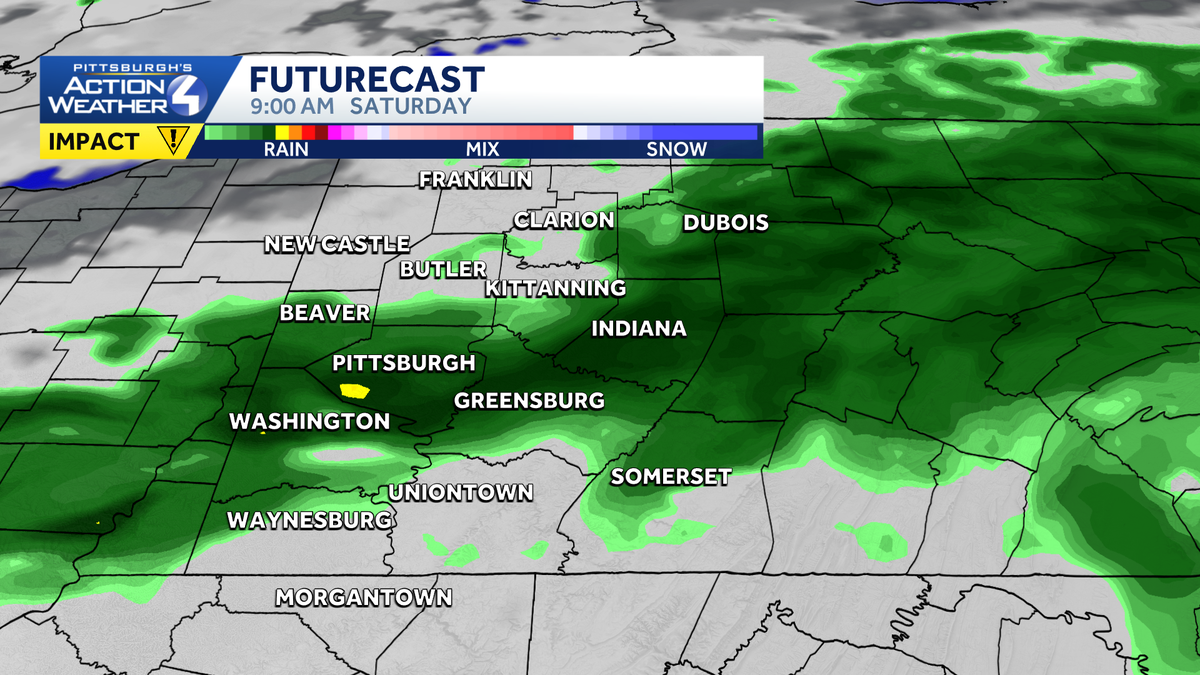
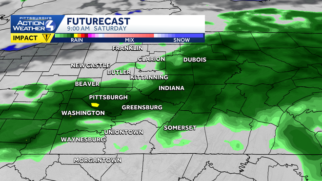
The most widespread rain on Saturday will fall before noon.
Rain expected for part of the weekend. Pockets of heavier rain are expected early Saturday morning, making Saturday an Impact Day. Rain looks to push out by lunchtime on Saturday, and we will remain dry until a cold front approaches late Saturday night and into Sunday morning. The timing of the rain has been back and forth for Sunday, but we can’t rule out a few showers early morning, dry through the day with another round of isolated showers Sunday evening.
Hearst Owned
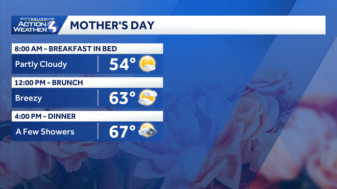
A few showers are possible on Mother’s Day. The best chance to see rain is either very early or very late in the day.
Finally Warming Up
The cool start to May continues next week. Monday will struggle to get out of the 50s with frost possible Tuesday morning. Rain showers return on Wednesday as a system drops into the area. We finally start to warm up late next week as highs return to the 70s, which is where we are supposed to be for the middle of May.
Hearst Owned
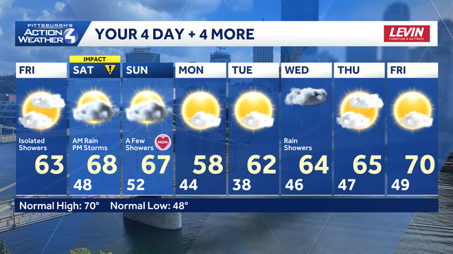
Cool with showers, but we finally turn seasonal late next week.
TODAY: Mostly cloudy with isolated showers. High: 63°
TONIGHT: Rain developing, isolated storm possible. Low: 48°
SATURDAY – Impact Day: Morning rain then mostly cloudy with late day storms. High: 68°, low: 52°.
SUNDAY: Mostly cloudy with scattered showers. High: 67°, low: 44°.