
Rain to showers Saturday, Mother’s Day looking mainly dry for south-central Pennsylvania
Highs will stay in the 60s for the next 2 days, then warm to the 70s on Mother’s Day
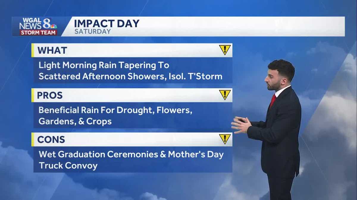
FOR THE COMMUNITY’S SUPPORT AND HELPING THEM GET BACK ON THEIR FEET. NOW, THE WGAL NEWS EIGHT STORM TEAM FORECAST WITH METEOROLOGIST RYAN ARGENTI WATCHING A SWATH OF SOME SHOWERS BEGINNING TO CLOSE INTO THE SUSQUEHANNA VALLEY. YOU CAN SEE ON STORM TEAM LIVE RADAR NETWORK SOME LIGHT RAIN SHOWERS BEGINNING TO PUSH IN FROM WEST TO EAST. AT THIS TIME. WE’RE GOING TO CONTINUE TO TRACK THAT AS WE GET INTO THE EVENING, AND THEN THE BREEZE WILL ALSO DIE DOWN ONCE WE GET TO OR ONCE IT. ONCE WE GET RIGHT AROUND DARK TIME OR AFTER DARK IS WHEN WE’LL EXPECT THAT BREEZE REALLY DIE DOWN. BUT THEN SATURDAY WE HAVE IT AS AN IMPACT IMPACT DAY. AND THAT’S MAINLY BECAUSE OF THE HOW DAMP IT’S GOING TO BE FOR THE MORNING. WE HAVE A LOT OF EVENTS THAT ARE GOING TO BE HAPPENING THAT WE’LL CHAT ABOUT HERE IN A SECOND, BUT WE HAVE MORNING RAIN SHOWERS AND AFTERNOON SHOWERS. WE COULD SEE THE CHANCE OF A COUPLE OR FEW STORMS MOVE THROUGH LATER IN THE DAY SATURDAY. THEN IT WILL BE A BRIGHT START TO OUR MOTHER’S DAY ON SUNDAY. HIGHS GETTING INTO THE 70S. WE ARE LOOKING AT A FEW MORE AFTERNOON AND EVENING SHOWERS, WHICH YOU’LL SEE IN THE TEN DAY FORECAST HERE IN JUST A FEW MINUTES. SO FOR THIS EVENING, EXPECT THOSE MOSTLY CLOUDY CONDITIONS TO START TO CONTINUE TO BUILD. WE’LL SEE THOSE SCATTERED SHOWER CHANCES FOR THE EVENING WITH DIMINISHING WINDS OUT OF THE WEST NORTHWEST TEMPERATURES DROPPING DOWN INTO THE LOWER 60S. THEN FOR TONIGHT, 50 TO 54 CLOUDY SKIES. WE’LL SEE SOME OF THAT LIGHT RAIN BEGIN TO BUILD IN LATE, BUT IT WON’T BE AS COLD, THOUGH YOU CAN SEE TEMPERATURES GETTING INTO THE LOWER 50S. AND THEN HERE COMES TOMORROW. WE’RE EXPECTING LATE MORNING RAIN AND THEN SCATTERED AFTERNOON AND EVENING SHOWERS, BUT CAN’T RULE OUT THE CHANCE OF AN ISOLATED THUNDERSTORM. IT’S GOING TO BE A COOL DAY TO 62 TO 66 DEGREES. AND THEN THE REASON WHY WE HAVE IT AS AN IMPACT DAY IS BECAUSE WE HAVE A LOT OF EVENTS THAT ARE GOING TO BE HAPPENING FOR THE DAY. NOW, THERE ARE SOME PROS TO TO THESE SHOWERS. IT’S BENEFICIAL RAIN FOR THE DROUGHT. WE HAVE THE FLOWERS, GARDENS, CROPS, RIGHT. IT’S GOING TO BE GOOD FOR THE FOR ANY OF THE AGRICULTURE, BUT WE HAVE A LOT OF EVENTS SUCH AS THE GRADUATION CEREMONIES, EVEN PARENTS THAT ARE TAKING PICTURES WITH THE KIDS GRADUATING. WE HAVE THE MOTHER’S DAY TRUCK CONVOY THAT’S GOING TO BE HAPPENING IN THE FIRST HALF OF THE DAY SATURDAY. SO FOR THOSE FOLKS ARE GOING TO BE ATTENDING, OR IF YOU HAVE ANYBODY THAT’S, YOU KNOW, IF YOU’RE GOING TO ANY GRADUATION CEREMONIES, IT’S GOING TO BE A BIT OF A DAMP START TO THE DAY. SO JUST KEEP THAT IN MIND, BRING AN EXTRA PONCHO OR UMBRELLA ONCE WE GET TO OUR SATURDAY. NOW IN TERMS OF POLLEN LEVELS FOR THE TREES AND GRASS REMAINING MODERATE, LOW MOLD LEVELS, MODERATE AIR QUALITY FOR FOR THE PARTICULATE MATTER UV INDEX, IT’S LOW. WE HAVE ABOUT A 45 MINUTE BURN TIME FOR THE AFTERNOON AND RAIN CHANCES AFTER. ONCE WE GET BEYOND TOMORROW, SUNDAY, LOOKING AT SOME LATE AFTERNOON SHOWERS AND WE HAVE SOME EARLY SHOWER CHANCES FOR YOUR MONDAY. BUT TUESDAY SO FAR. LOOKING DRY NOW. TEMPERATURES ARE INTO THE 60S FOR THE MAJORITY OF THE AREA. WE’RE 59 IN LEWISTOWN, 67 IN CHAMBERSBURG, 65 IN CARLISLE AND STILL HAVE THOSE PERSISTENT WINDS OUT OF THE WEST NORTHWEST, BUT STILL WATCHING THESE SHOWERS MOVE THROUGH THE AREA. YOU CAN SEE THAT, LIKE I MENTIONED EARLIER, AT THE TOP OF THE PRESENTATION HERE, STILL WATCHING SOME OF THESE SHOWER CHANCES OR THESE SHOWERS BEGINNING TO, TO TO MOVE INTO THE AREA. SO TIMING EVERYTHING OUT FOR YOU, THE MORE PERSISTENT SHOWERS DON’T COME INTO THE PICTURE UNTIL WE GET TO SATURDAY MORNING. YOU CAN SEE THIS WARM FRONT STARTING TO LIFT THROUGH THE SUSQUEHANNA VALLEY. THAT’S GOING TO ALLOW FOR THOSE FOR THAT THOSE RAIN SHOWERS AND THEN TAPER TO SHOWERS LATER ON IN THE AFTERNOON CLEARS OUT IN THE WAKE OF THE COLD FRONT. SEEING SOME CLEARING FOR THE BEGINNING OF OUR SUNDAY. BUT THEN AS WE GET INTO THE AFTERNOON SUNDAY, ANOTHER COLD FRONT STARTS TO PUSH THROUGH. THAT’S GOING TO START TO POP UP SOME ADDITIONAL SHOWERS. AND ALONG THIS FRONT MAY SEE ME HEAR A COUPLE RUMBLES OF THUNDER OR TWO AS WE GET INTO LATER IN THE EVENING. SO ABOUT A QUARTER TO HALF INCH OF SOME RAIN IS POSSIBLE AS WE HEAD. BY THE TIME WE GET TO SATURDAY. LOOKING AHEAD INTO NEXT WEEK, MONDAY, LIKE I MENTIONED, SHOWERS EARLY DOWN INTO THE LOWER 60S. CHANCE OF SHOWE
Rain to showers Saturday, Mother’s Day looking mainly dry for south-central Pennsylvania
Highs will stay in the 60s for the next 2 days, then warm to the 70s on Mother’s Day

Updated: 4:37 PM EDT May 8, 2026
Clouds are gradually increasing heading into the evening. Isolated showers will continue moving through the area, taper briefly, before light rain develops late. The 10-20 mph northwesterly breeze will diminish late this evening and temperatures will drop through the lower 60s.Mostly cloudy skies are in store tonight, and temperatures won’t be as cold as this morning. Expect lows near 52. Light rain will develop by sunrise across most of the area.IMPACT SATURDAY:We’re expecting steady, light rain Saturday morning. Good news for the drought, but bad news for outdoor college graduations and the Mother’s Day Truck Convoy! The rain will taper by early afternoon. As a cold front passes, a few showers and isolated thunderstorms are possible toward evening. Highs will reach 64 degrees and rain totals will be around 0.25″ for most, but could be up to 0.50″ north.Mother’s Day will feature morning sunshine, then increasing clouds and a few showers in the afternoon and evening ahead of a cold front. Highs will be warmer, around 74 degrees.After a cold front passes, showers will wrap up Monday morning. Look for partial clearing and below average highs around 62. Tuesday will be breezy and cool, with highs in the lower 60s. The next chance of showers arrives Wednesday, along with cool temperatures near 60 degrees.At the end of the work week, temperatures rebound to the mid-to-upper 60s with a few rain chances Thursday and Friday. Warmer temperatures in the mid-70s are expected for the following weekend.
Clouds are gradually increasing heading into the evening. Isolated showers will continue moving through the area, taper briefly, before light rain develops late. The 10-20 mph northwesterly breeze will diminish late this evening and temperatures will drop through the lower 60s.
Mostly cloudy skies are in store tonight, and temperatures won’t be as cold as this morning. Expect lows near 52. Light rain will develop by sunrise across most of the area.
IMPACT SATURDAY:
We’re expecting steady, light rain Saturday morning. Good news for the drought, but bad news for outdoor college graduations and the Mother’s Day Truck Convoy! The rain will taper by early afternoon. As a cold front passes, a few showers and isolated thunderstorms are possible toward evening. Highs will reach 64 degrees and rain totals will be around 0.25″ for most, but could be up to 0.50″ north.
Mother’s Day will feature morning sunshine, then increasing clouds and a few showers in the afternoon and evening ahead of a cold front. Highs will be warmer, around 74 degrees.
After a cold front passes, showers will wrap up Monday morning. Look for partial clearing and below average highs around 62. Tuesday will be breezy and cool, with highs in the lower 60s. The next chance of showers arrives Wednesday, along with cool temperatures near 60 degrees.
At the end of the work week, temperatures rebound to the mid-to-upper 60s with a few rain chances Thursday and Friday. Warmer temperatures in the mid-70s are expected for the following weekend.